Tectonic Processes and Geohazards
Research in Tectonic Processes and Geohazards focuses on integrating field investigations, laboratory analysis, and computational modeling to tackle the problem of deformation and change in the continental lithosphere on time scales ranging from short-term earthquake events to long-term tectonic deformation processes, and for spatial scales ranging from microstructures, visible under electronic microscopes, to the tectonic, continental scales.
Primary Faculty: Jiang, Molnar, Shcherbakov, Goda
Multi-Hazard Risk Research Group
Dr. Katsu Goda
Canada has a high likelihood of facing significant earthquake threats in future. In Eastern Canada, damaging earthquakes occurred in the Charlevoix and Western Quebec seismic zones and recurrence of similar events is anticipated. In Western Canada, British Columbia is exposed to major seismic hazards and related secondary hazards (e.g. tsunami and liquefaction), originating from the Cascadia subduction zone. Scenarios of particular concern to Canadian residents, emergency managers and businesses are the future occurrences of a mega-thrust earthquake in Cascadia and a moderate earthquake along St. Lawrence River (Ottawa-Montreal-Quebec City corridor), which will generate large-scale multi-hazard cascades and affect the population and built environment simultaneously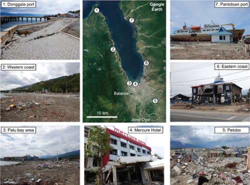
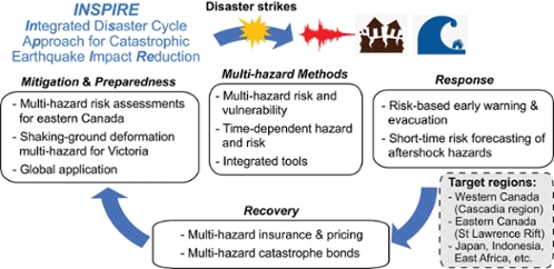
The Multi-hazard Risk Research Group conducts an interdisciplinary INSPIRE (Integrated Disaster Cycle Approach for Catastrophic Earthquake Impact Reduction) research program related to earthquake-triggered multi-hazards that affect communities in Canada and around the world. We develop integrated disaster risk reduction tools for earthquake catastrophes by implementing innovative multi-hazard methods and recognizing three main phases of disaster risk management: mitigation, preparedness, response, and recovery. We are interested in investigating cascading hazards (shaking-tsunami-aftershocks) by accounting for physical causes of the multi-hazards and by evaluating the effectiveness of response and recovery measures for mitigating impacts and enhancing seismic resilience of built environments. The tools enable new approaches for more efficient disaster risk management and mitigation over the entire disaster cycle. We also do fieldwork by visiting disaster-hit regions (e.g. 2018 Palu, Sulawesi earthquake).
Laboratory for Deformation Structures
Dr. Dazhi Jiang
We use deformation structures and fabrics preserved in rocks to unravel the tectonic evolution of orogenic belts and to constrain the long-term rheology of the continental crust. Field mapping of critical areas are combined with laboratory microstructural analysis and numerical modeling to understand the kinematics and mechanics of natural rock deformation. The Laboratory is equipped with the latest, top-end equipment for this integrated research endeavour including:
Microstructural Analysis Facility: This facility includes an EBSD detector attached to the SEM for Lattice-Preferred Orientation analysis and phase identification, four state-of-the-art (Leica and Nikon) microscopes with digital cameras and image analysis software for thin-section scale microstructural analysis, one precision-cut diamond saw and a Vibratory Polisher for sample preparation.
- Field Mapping Facility: This includes one Trimble Pathfinder ProXRT receiver, three Trimble GeoXH handheld units for high-precision digital mapping in selected critical areas, and one truck for field use.
- Computational Facility: Four state-of-the-art computer workstations with the latest software (commercial as well as those developed by Dr. Jiang) installed for the numerical modeling of tectonic deformation and the development of geological structures.
Dr. Jiang's current field research areas include the Canadian Shield, Canadian Cordillera, and East China.
Nonlinear Geophysics Modeling Lab
Dr. Robert ShcherbakovThe main focus of our research is to understand the physics of various complex nonlinear phenomena observed in nature. Such behavior can be found at different temporal and spatial levels of organization of natural systems and is characterized by highly nonlinear interactions among their constituent parts and behavior far from equilibrium. The undertaken research involves extensive computer modeling, data analysis, and visualization. The following topics are of particular interest and addressed in our studies:
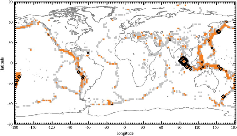
Spatial distribution of 2° × 2° alarm cells for a Benioff strain relative intensity forecast (from Shcherbakov et al., 2010)
- Earthquake physics and statistics. Analysis of temporal and spatial scaling properties of earthquakes and aftershocks. Large-scale computer simulations of seismicity. Earthquake hazard assessment and forecasting.
- Continuum damage and fracture mechanics. Applications to fracture processes in solids and the earth’s crust. Numerical and analytical modeling of the evolution of damage, nucleation and interaction of cracks.
- Extreme events in nature and society. Analysis of record breaking events in driven nonlinear threshold systems.
- Planetary geodynamics and the internal structure of the Earth and planets. Cross-correlation analysis of gravity and topography signals to infer the evolution and elastic properties of the lithosphere.
- Self-organized critical behavior in nonlinear dissipative complex systems. Analysis of pattern formation and criticality in cellular automata and their application to natural phenomena. Stochastic Monte-Carlo simulations of various cellular automata.
Good Vibrations and Excitations Research Group
Dr. Sheri MolnarThe primary focus of our research group is developing and advancing various field (in situ) and computational techniques to predict seismic hazards and analyze risks from natural and induced earthquakes. Our research activities and team members span geophysics, engineering seismology, earthquake and geotechnical engineering, geology, and geography.
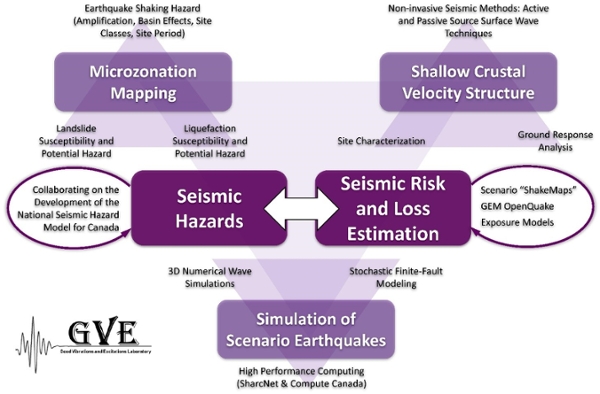
Research Activities:
- Microzonation Mapping; assessment and mapping of earthquake shaking hazard (amplification, basin effects, site class, site period); liquefaction and landslide susceptibility and potential hazard.
- Earthquake Path and Site Effects; predicting changes in frequency, amplitude and duration of ground motion as seismic waves travel through Earth material to the ground surface.
- Shallow Crustal Velocity Structure; development of non-invasive seismic methods including active and passive (ambient vibrations or microtremors) source surface wave techniques to determine the Earth’s velocity structure for earthquake site characterization and ground response analysis.
- Simulation of Scenario Earthquakes; performing 3D numerical wave propagation simulations of various scenario earthquake ruptures to generate long-period shaking estimates and stochastic finite-fault modeling to generate shorter-period shaking estimates. High performance computing is achieved via SharcNet and Compute Canada.
- Seismic Hazards Due to (Natural and) Induced Seismicity; collaborating on the development of the national seismic hazard model for Canada, studying parameters that control seismicity hazard and spatio-temporal attributes of induced events.
- Seismic Risk and Loss Estimation; development of seismic hazard and scenario “ShakeMaps” as input for seismic risk analysis. We utilize the Global Earthquake Model (GEM) OpenQuake software along with exposure models developed by Natural Resources Canada (NRCan).