Five additional Prairie tornadoes from Aug 30
The NTP has confirmed five additional Prairies tornadoes from the storms on August 30. While all tornadoes were weak - rated EF1 or less - two of them occurred in Saskatchewan, another two occurred in Manitoba, and one occurred in Alberta. A previously confirmed tornado at Maryfield, Saskatchewan has also been updated with additional information.
Full details are available with the event summaries below, along with regional maps showing the locations of the new tornadoes. The events can also be plotted on a map using the NTP Dashboard here.
====
Event Name: Wawota, SK
Date: August 30, 2026
Start Time: 3:30 PM CST (2130 UTC)
Final Classification: Tornado (over land)
Final EF-Scale Rating: EF0-default
Start of damage track: 49.8617N, 102.0735W
End of damage track: 49.9178N, 102.1286W
Description: Witnesses captured video and photos of a vortex-funnel cloud aloft west of Wawota, though the view of the surface below was unclear. No damage was reported. Satellite imagery review revealed a path of crop damage in the area. As no damage indicators appear impacted, the EF-scale assessment is EF0-Default tornado, with a track length of 7.61 km and max. path width of 330 m. Tornado motion was from the SSE (approx. 150 degrees). Start time is radar estimated.
Event Name: Strathmore, AB
Date: August 30, 2026
Start Time: 3:43 PM MDT (2143 UTC)
Final Classification: Tornado (Over Land)
Final EF-Scale Rating EF0-Default
Estimated Tornado Location: 51.11N, 113.49W
Description: Witness captured video of a tornado northwest of Strathmore. With no damage reported or visible during satellite imagery review, event assessed as default EF0. Information available insufficient to accurately estimate track length, max. path width and tornado motion. Start time is based on witness report.
Event Name: Maryfield, SK
Date: August 30, 2026
Start Time: 3:50 PM CST (2150 UTC)
Final Classification: Tornado (over land)
Final EF-Scale Rating: EF0-default
Start of damage track: 49.7680N, 101.4646W
End of damage track: 49.7889N, 101.4833W
Description: Witness captured video of a tornado southeast of Maryfield. No damage was reported. An NTP ground and drone survey team searched for damage in a limited area but found none. Satellite imagery review revealed a path of crop damage in the vicinity. As no damage indicators appear impacted, the EF-scale assessment is EF0-Default tornado, with a track length of 2.75 km and max. path width of 270 m. Tornado motion was from the SSE (approx. 150 degrees). Start time is radar estimated.
Event Name: Vandura, SK
Date: August 30, 2026
Start Time: 4:10 PM CST (2210 UTC)
Final Classification: Tornado (over land)
Final EF-Scale Rating: EF0-default
Start of damage track: 49.9906N, 102.0617W
End of damage track: 49.9934N, 102.0699W
Description: Witness captured video of a vortex-funnel cloud aloft at Vandura, though the view of the surface below was obscured by trees. No damage was reported. Satellite imagery review revealed a short path of crop damage in the area. As no damage indicators appear impacted, the EF-scale assessment is EF0-Default tornado, with a track length of 0.69 km and max. path width of 110 m. Tornado motion was from the ESE (approx. 120 degrees). Start time is radar estimated.
Event Name: Kola (2), MB
Date: August 30, 2026
Start Time: 5:42 PM CDT (2242 UTC)
Final Classification: Tornado (over land)
Final EF-Scale Rating: EF0-default
Start of damage track: 49.9154N, 101.3882W
End of damage track: 49.9252N, 101.4011W
Description: Satellite imagery review of a storm track of interest revealed a narrow path of crop damage north of Kola. Radar imagery review confirmed a velocity couplet was detected in the immediate vicinity and a tornado likely developed. As no damage indicators appear impacted, the EF-scale assessment is EF0-Default tornado, with a track length of 1.53 km and max. path width of 120 m. Tornado motion was from the SE (approx. 140 degrees). Start time is radar estimated.
Event Name: Blue Lakes, MB
Date: August 30, 2026
Start Time: 8:15 PM CDT (0115 UTC)
Final Classification: Tornado (over land)
Final EF-Scale Rating: EF1
EF-Scale Damage Indicator / Degree of Damage: C-T/DOD-5
Start of damage track: 51.6064N, 100.9142W
End of damage track: 51.6318N, 100.912W
Location of worst damage: 51.6287N, 100.9104W
Description: Roof damage to a store and heavy items being moved by strong winds (an A/C unit and small shed) was reported at Blue Lakes Campground after a storm passed through the area. No injuries were reported. Satellite imagery review revealed a narrow path of tree damage in a forested area north of the campground. Damage assessed as EF1 tornado, with an estimated max. wind speed of 145 km/h, track length of 2.93 km and max. path width of 250 m. Tornado motion was from the S (approx. 185 degrees). Start time is based on witness report.
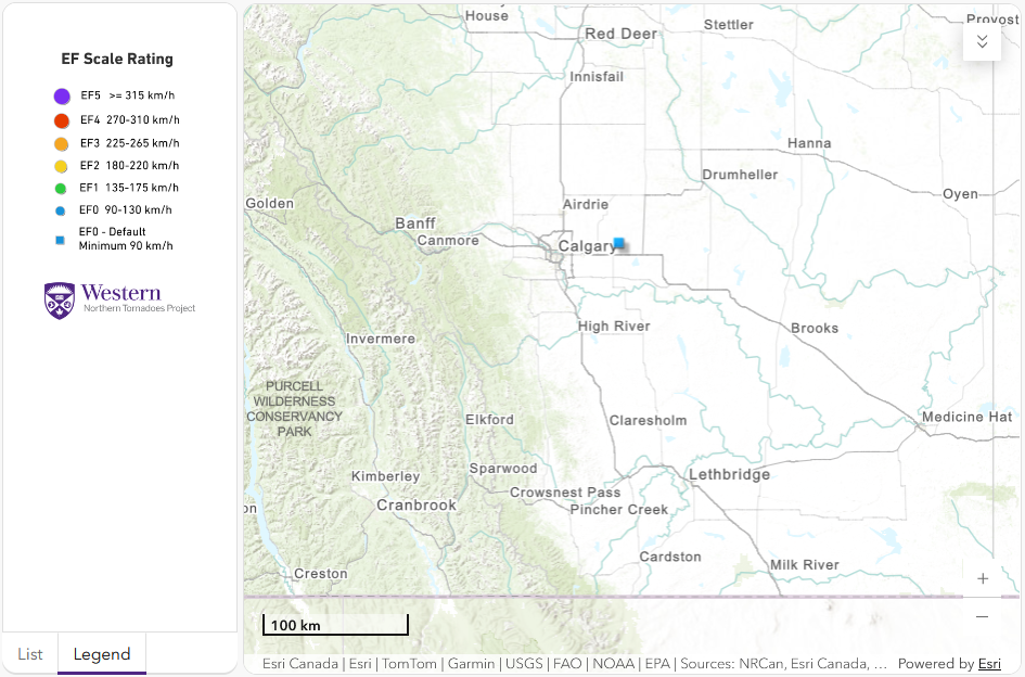
Regional map showing the start location of the tornado near Strathmore, AB on Aug 30.
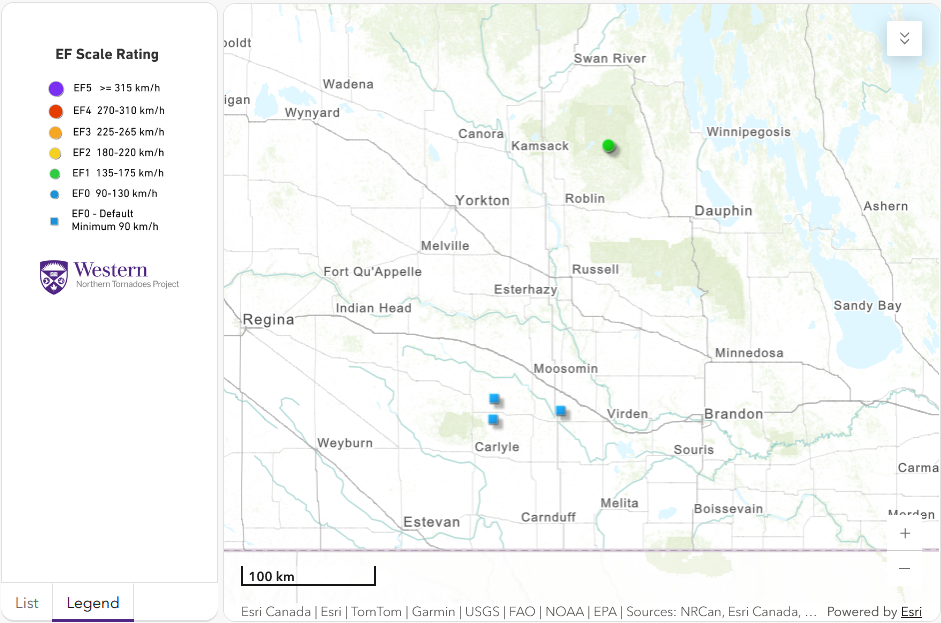
Regional map showing the start locations of the tornadoes near the SK / MB border on Aug 30.





