Additional tornadoes and a downburst confirmed for southern SK
The NTP has confirmed three additional tornadoes and a downburst for southern Saskatchewan - a tornado from back on May 31 that was assigned an EF0-Default rating, and two EF1 tornadoes and an EF0 downburst from June 7.
Additional details are provided in the event summaries below, along with a regional map, a survey summary map, and survey photos. The event can also be plotted on a map using the NTP Dashboard here.
====
Event Name: Laporte, SK
Date: May 31, 2026
Start Time: 1:37 PM CST (1937 UTC)
Final Classification: Tornado (Over Land)
Preliminary EF-Scale Rating: EF0-Default
Estimated Tornado Location: 51.14N, 109.47W
Description: Witness reported a tornado and captured video of the associated funnel cloud south of Laporte. As no damage was found and satellite imagery review revealed no visible damage, the EF-scale assessment is default EF0. Information available insufficient to accurately estimate track length, max. path width and tornado motion. Start time is based on witness report.
Event Name: Glen Ewen, SK
Date: June 7, 2026
Start Time: 8:10 PM CST (0210 UTC)
Final Classification: Tornado (over land)
Final EF-Scale Rating: EF1
EF-Scale Damage Indicator / Degree of Damage: C-ETL/DOD-1
Start of damage track: 49.1370N, 102.0029W
End of damage track: 49.1789N, 101.9347W
Location of worst damage: 49.1465N, 101.9875W
Description: Damage to a home, trees and recreational trailer was reported at a property south of Glen Ewen after a storm passed through the area. No injuries were reported. An NTP ground and drone survey was completed on June 11-12, 2026, documenting the reported damage and discovering additional damage to power poles and trees. Satellite imagery review did not reveal any visible damage. Damage assessed as an EF1 tornado, with an estimated max. wind speed of 145 km/h, track length of 6.83 km and max. path width of 240 m. Tornado motion was from the SW (approx. 225 degrees). Start time is based on witness reports.
Event Name: Carnduff, SK
Date: June 7, 2026
Start Time: 8:20 PM CST (0220 UTC)
Final Classification: Tornado (over land)
Final EF-Scale Rating: EF1
EF-Scale Damage Indicator / Degree of Damage: SBO/DOD-7
Start of damage track: 49.2061N, 101.8873W
End of damage track: 49.2947N, 101.8241W
Location of worst damage: 49.2698N, 101.8322W
Description: An NTP survey team visiting the Carnduff area discovered a path of damage from a storm on June 7, 2026, including a destroyed farm outbuilding and tree damage. No injuries were reported. The ground and drone survey was completed on June 12, 2026. Satellite imagery review did not reveal any visible damage. Damage assessed as an EF1 tornado, with an estimated max. wind speed of 140 km/h, track length of 11.3 km and max. path width of 780 m. Tornado motion was from the SSW (approx. 205 degrees). Start time is radar estimated.
Event Name: Oxbow, SK
Date: June 7, 2026
Start Time: 8:20 PM CST (0220 UTC)
Final Classification: Downburst
Final EF-Scale Rating: EF0
EF-Scale Damage Indicator / Degree of Damage: SRB/DOD-4
Location of worst damage: 49.2262N, 102.1603W
Description: Damage to a commercial building, a barn and trees was reported in the Oxbow area after a storm passed through. No injuries were reported. An NTP ground and drone survey was completed on June 10, 2026, documenting the reported damage and additional damage to a grain bin. Satellite imagery review did not reveal any visible damage. Damage assessed as EF0 downburst, with an estimated max. wind speed of 130 km/h, with damage found over an area approximately 15 km long and up to 6 km wide. Start time is radar estimated.
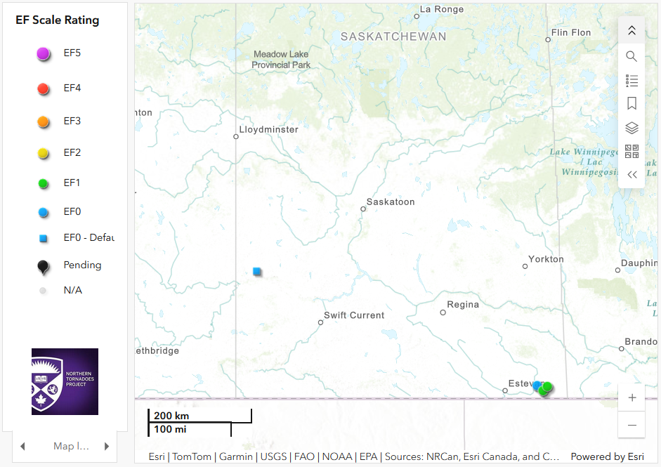
Regional map showing the locations of the tornado from May 31 (left) and the two tornadoes and downburst from June 7 (right).
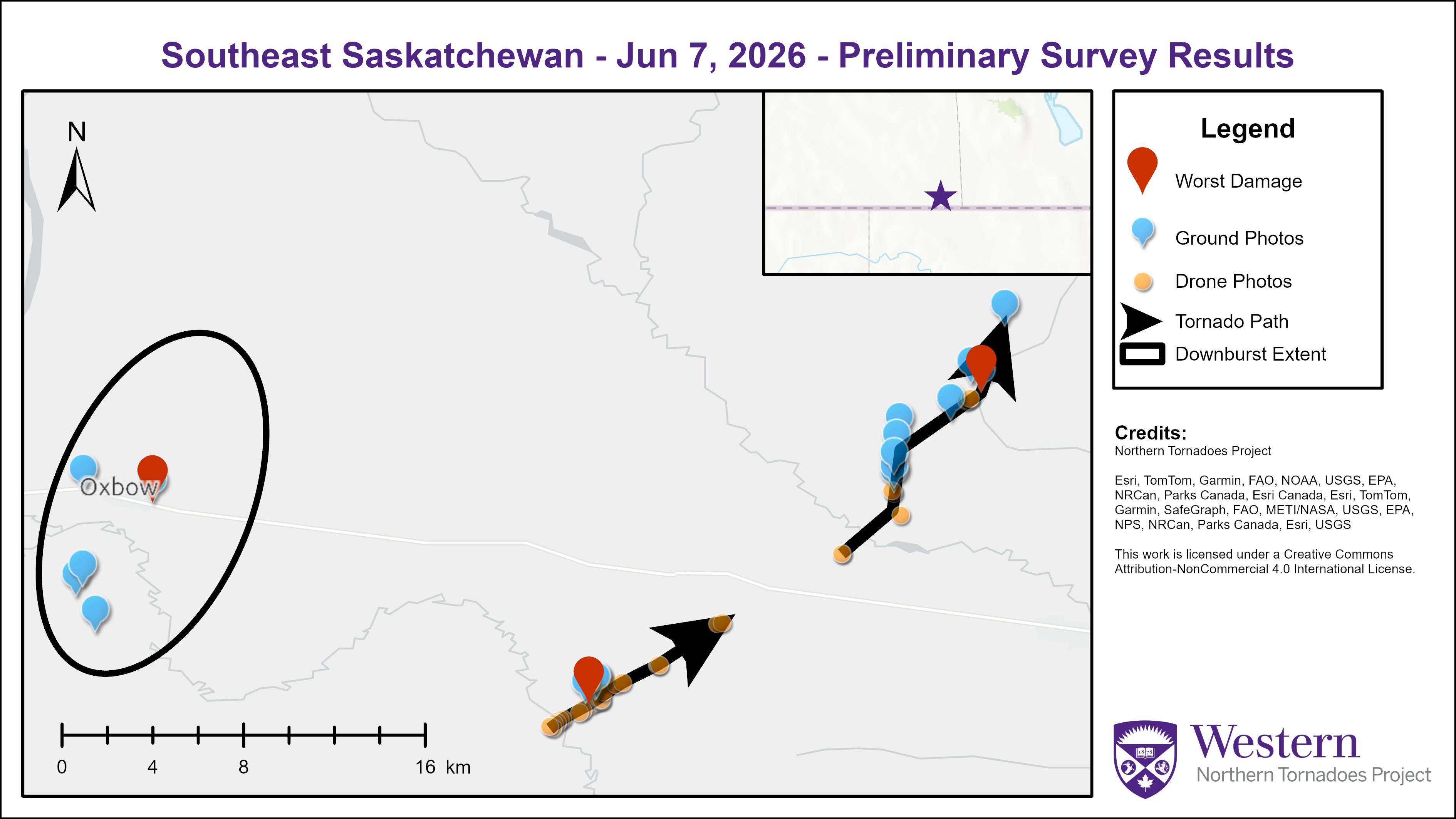
Survey summary map for the two EF1 tornadoes and the EF0 downburst from June 7.
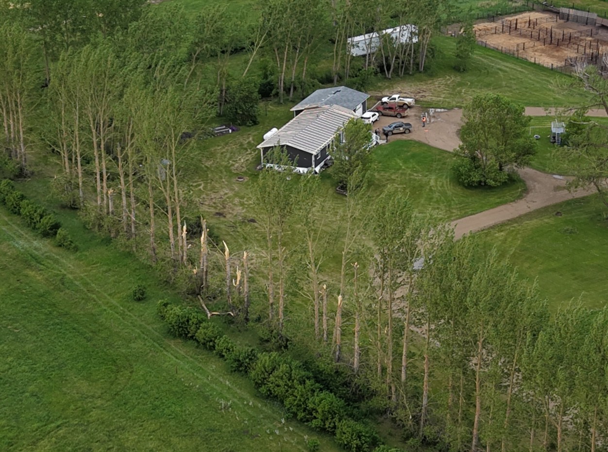
Drone photo showing snapped trees, the loss of roof covering on the home, and a trailer in the background that was overturned by the EF1 tornado. The electrical pole had been replaced so no photo of is shown for that DI.
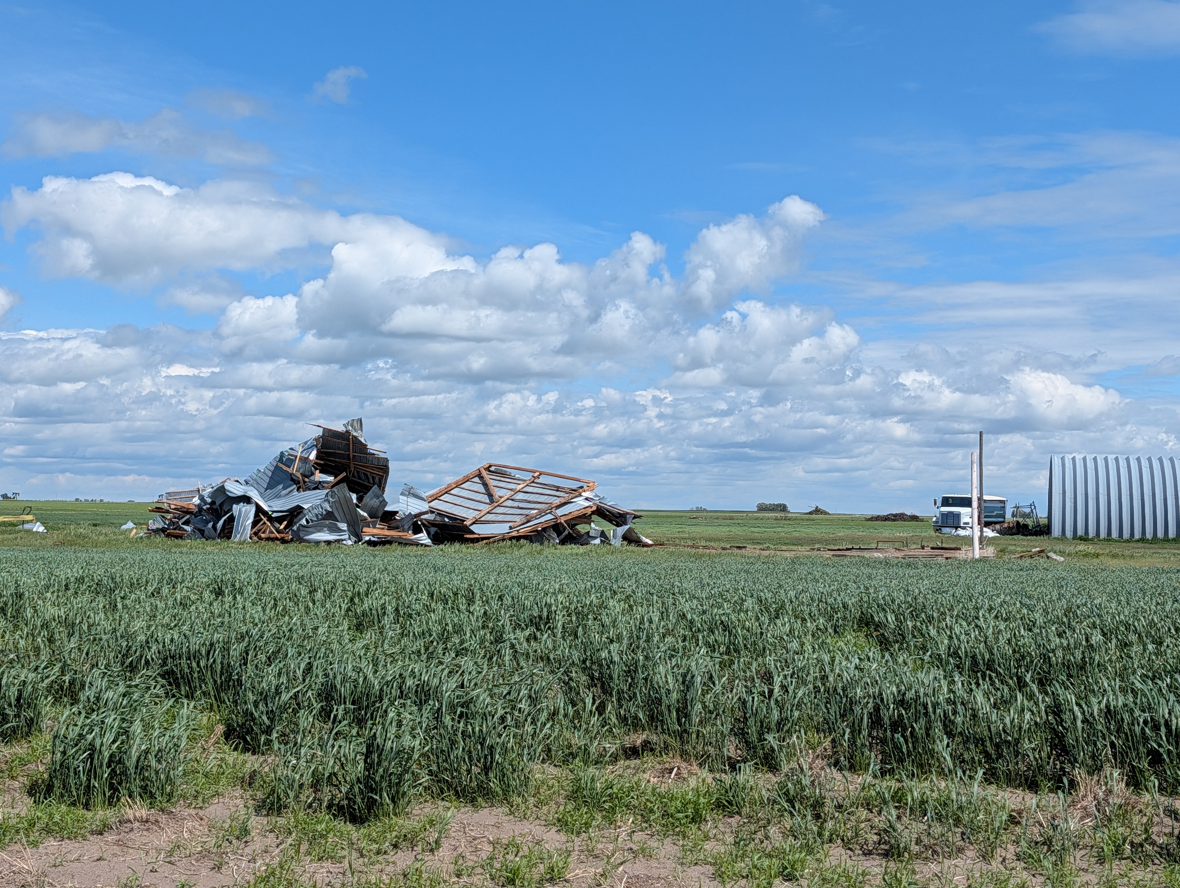
The worst damage point for the Carnduff EF1 tornado - a destroyed outbuilding along the track.
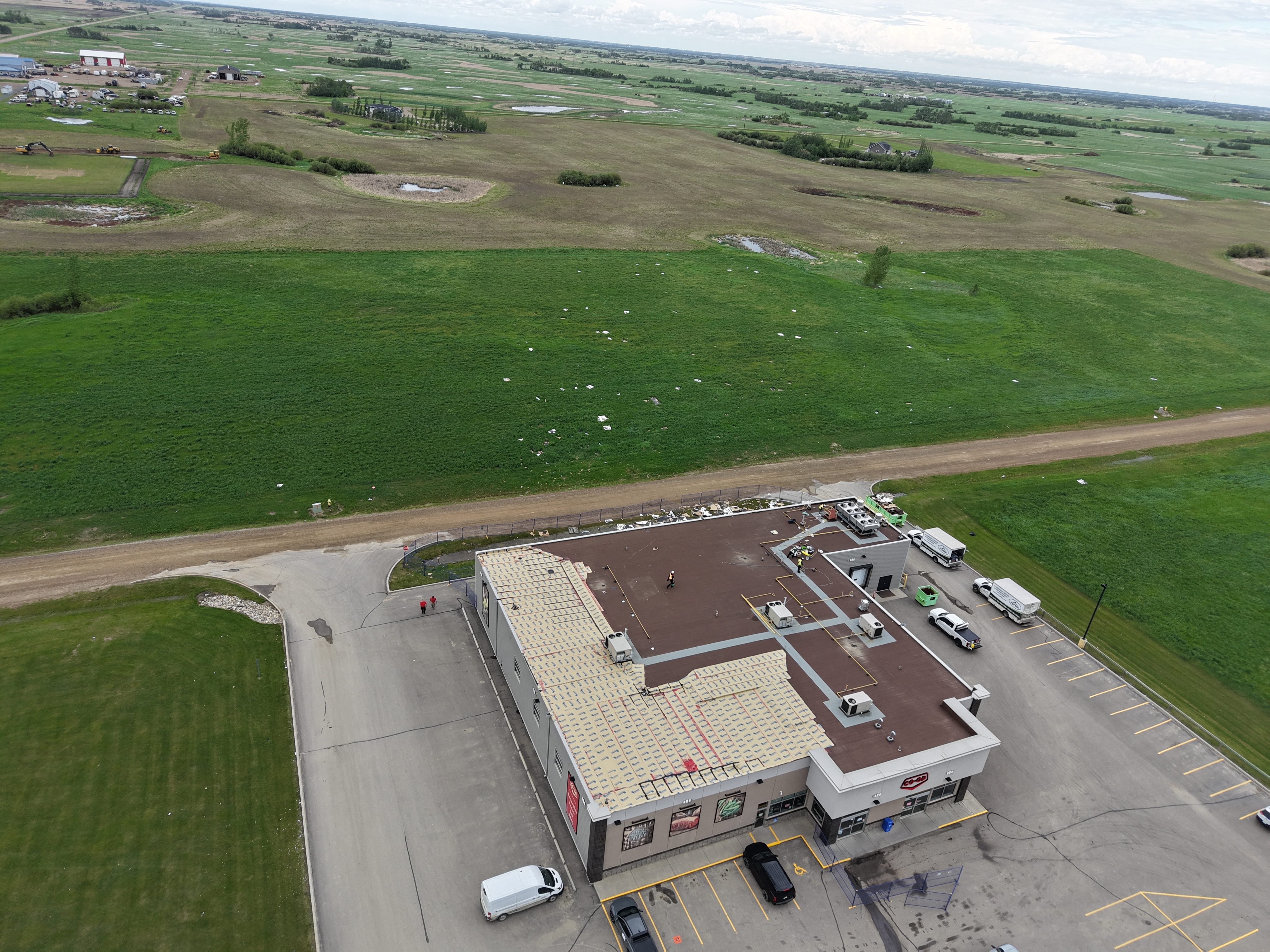
The worst damage point for the Oxbow EF0 downburst - damage to the roof of a small retail building with the debris spread into the adjacent field.