Six more Prairie tornadoes for 2025
The NTP has confirmed six additional Prairie tornadoes with ratings ranging from EF2 to EF0-Default. Four of these are based on AI-assisted satellite review of forest areas in AB and SK, while two of these (plus an update of an existing tornado) in AB are based on reports from Riley Weekes (@RJTornado).
Details are provided in the event summaries below, along with a regional map. The tornadoes can be plotted on a map using the NTP Dashboard here.
====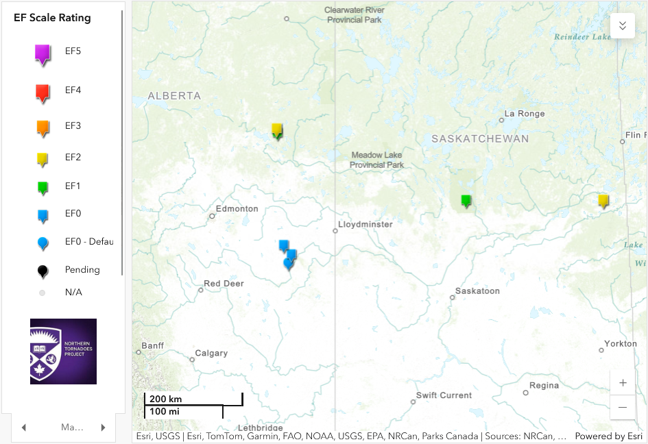
Map showing the locations of the six new tornadoes and one updated tornado.
Event Name: Shaw Lake, AB
Date: July 2, 2025
Start Time: 11:25 PM MDT (0525 UTC)
Final Classification: Tornado (over land)
Final EF-Scale Rating: EF1
EF-Scale Damage Indicator / Degree of Damage: C-T/DOD-5
Start of damage track: 54.7508N, 111.6525W
End of damage track: 54.7886N, 111.6009W
Location of worst damage: 54.7704N, 111.6229W
Description: AI-assisted satellite imagery review identified a tornado damage path in forested areas near Shaw Lake (east of Lac la Biche). Tornado damage assessed as EF1, with an estimated max. wind speed of 145 km/h, track length of 5.43 km and max. path width of 520 m. Tornado motion was from the SW (approx. 220 degrees). Start time is radar estimated. Weak downburst damage was also visible in the area.
Event Name: Jackson Lake, AB
Date: July 2, 2025
Start Time: 11:30 PM MDT (0530 UTC)
Final Classification: Tornado (over land)
Final EF-Scale Rating: EF2
EF-Scale Damage Indicator / Degree of Damage: C-T/DOD-6
Start of damage track: 54.8579N, 111.6589W
End of damage track: 54.8696N, 111.6582W
Location of worst damage: 54.8640N, 111.6576W
Description: AI-assisted satellite imagery review identified a tornado damage path in forested areas near Jackson Lake (northeast of Lac la Biche). Tornado damage assessed as EF2, with an estimated max. wind speed of 190 km/h, track length of 1.32 km and max. path width of 190 m. Tornado motion was from the S (approx. 185 degrees). Start time is radar estimated.
Event Name: Hunters Lake, SK
Date: August 13, 2025
Start Time: 6:45 PM CST (0045 UTC)
Final Classification: Tornado (over land)
Final EF-Scale Rating: EF1
EF-Scale Damage Indicator / Degree of Damage: C-T/DOD-5
Start of damage track: 53.6314N, 106.3101W
End of damage track: 53.6378N, 106.2686W
Location of worst damage: 53.6370N, 106.2718W
Description: AI-assisted satellite imagery review identified a tornado damage path in forested areas near Hunters Lake (north of Cookson). Tornado damage assessed as EF1, with an estimated max. wind speed of 145 km/h, track length of 2.85 km and max. path width of 330 m. Tornado motion was from the WSW (approx. 255 degrees). Start time is radar estimated. Weak downburst damage was also visible in the area.
Event Name: Wapisew Lake, SK
Date: August 21, 2025
Start Time: 1:30 AM CST (0730 UTC)
Final Classification: Tornado (over land)
Final EF-Scale Rating: EF2
EF-Scale Damage Indicator / Degree of Damage: C-T/DOD-6
Start of damage track: 53.6883N, 102.4210W
End of damage track: 53.6999N, 102.3878W
Location of worst damage: 53.6982N, 102.3909W
Description: AI-assisted satellite imagery review identified a tornado damage path in forested areas near Wapisew Lake (south of Cumberland House). Tornado damage assessed as EF2, with an estimated max. wind speed of 190 km/h, track length of 2.58 km and max. path width of 460 m. Tornado motion was from the WSW (approx. 240 degrees). Start time is based on lightning and radar data.
Event Name: Hardisty (1), AB
Date: August 3, 2025
Start Time: 4:25 PM MDT (2225 UTC)
Final Classification: Tornado (over land)
Final EF-Scale Rating: EF0
EF-Scale Damage Indicator / Degree of Damage: C-T/DOD-3
Start of damage track: 52.7061N, 111.2455W
End of damage track: 52.711N, 111.290W
Location of worst damage: 52.7051N, 111.2690W
Description: Witnesses captured video and photos of a tornado northeast of Hardisty, causing minor tree damage and damage to crops. A private citizen captured drone imagery of the damage path, and satellite imagery review revealed parts of the damage path as well. Damage assessed as EF0 tornado, with an estimated max. wind speed of 115 km/h, track length of 3.43 km and max. path width of 80 m. Tornado motion was from the E (approx. 100 degrees). Start time is based on witness report and radar imagery. A second tornado (Hardisty (2)) developed approx. 5 km NW of this first tornado.
Event Name: Hardisty (2), AB
Date: August 3, 2025
Start Time: 4:40 PM MDT (2240 UTC)
Final Classification: Tornado (over land)
Final EF-Scale Rating: EF0-default
Start of damage track: 52.7508N, 111.3306W
End of damage track: 52.7678N, 111.3620W
Description: Witnesses captured video and photos of a funnel cloud north of Hardisty, where a path of crop damage was discovered during satellite imagery review. As no damage indicators appear impacted, the EF-Scale assessment is EF0-Default tornado, with a track length of 3.27 km and max. path width of 100 m. Tornado motion was from the SE (approx. 130 degrees). Start time is based on witness reports and radar imagery. The same parent cloud earlier produced an EF0 tornado northeast of Hardisty.
Event Name: Kinsella, AB
Date: August 3, 2025
Start Time: 5:10 PM MDT (2310 UTC)
Final Classification: Tornado (over land)
Final EF-Scale Rating: EF0
EF-Scale Damage Indicator / Degree of Damage: C-T/DOD-3
Start of damage track: 52.8713N, 111.4643W
End of damage track: 52.8868N, 111.5486W
Location of worst damage: 52.8722N, 111.4770W
Description: Witnesses captured video and photos of a funnel cloud south of Kinsella, where tree damage was later reported. Satellite imagery review revealed the damage path through cropland. Damage assessed as EF0 tornado, with an estimated max. wind speed of 115 km/h, track length of 6.43 km and max. path width of 60 m. Tornado motion was from the ESE (approx. 110 degrees). Start time is based on witness reports and radar imagery.