Eleven more ON tornadoes based on AI-assisted satellite review
The NTP has confirmed 11 new tornadoes in Ontario based on AI-assisted satellite review. All tornadoes caused only EF1-EF2 tree damage.
These are in addition to five tornadoes already confirmed in Northern Ontario via AI-assisted satellite review and published earlier. All sectors in Ontario have now been reviewed.
Details for the 11 new tornadoes are provided in the event summaries below. Also provided is a regional map showing their start locations. The tornadoes can be plotted on a map using the NTP Dashboard here.
====
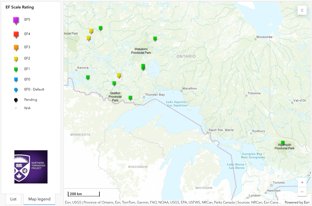
Regional map showing the start locations for the 11 new Ontario tornadoes.
Event Name: Storey Lake, ON
Date: July 10, 2025
Start Time: 5:05 PM CDT (2205 UTC)
Final Classification: Tornado (over land)
Final EF-Scale Rating: EF2
EF-Scale Damage Indicator / Degree of Damage: C-T/DOD-6
Start of damage track: 51.5588N, 93.3545W
End of damage track: 51.5827N, 93.3004W
Location of worst damage: 51.5789N, 93.3048W
Description: AI-assisted satellite imagery review identified a tornado damage path in forested areas at Storey Lake (west of Pikangikum). Tornado damage assessed as EF2, with an estimated max. wind speed of 190 km/h, track length of 4.70 km and max. path width of 210 m. Tornado motion was from the SW (approx. 235 degrees). Start time is radar estimated.
Event Name: Hemlock Lake, ON
Date: July 17, 2025
Start Time: 8:55 AM EDT (1255 UTC)
Final Classification: Tornado (over land)
Final EF-Scale Rating: EF1
EF-Scale Damage Indicator / Degree of Damage: C-T/DOD-5
Start of damage track: 45.8086N, 78.5383W
End of damage track: 45.8168N, 78.5107W
Location of worst damage: 45.8151N, 78.5179W
Description: AI-assisted satellite imagery review identified a tornado damage path in forested areas near Hemlock Lake in Algonquin Provincial Park. Tornado damage assessed as EF1, with an estimated max. wind speed of 145 km/h, track length of 2.36 km and max. path width of 230 m. Tornado motion was from the WSW (approx. 245 degrees). Start time is radar estimated.
Event Name: Otterskin Lake, ON
Date: July 22, 2025
Start Time: 7:20 PM CDT (0020 UTC)
Final Classification: Tornado (over land)
Final EF-Scale Rating: EF1
EF-Scale Damage Indicator / Degree of Damage: C-T/DOD-5
Start of damage track: 49.2284N, 93.6291W
End of damage track: 49.2284N, 93.6110W
Location of worst damage: 49.2286N, 93.6265W
Description: AI-assisted satellite imagery review identified a tornado damage path in forested areas near Otterskin Lake (west of Crow Lake). Tornado damage assessed as EF1, with an estimated max. wind speed of 145 km/h, track length of 1.33 km and max. path width of 190 m. Tornado motion was from the W (approx. 270 degrees). Start time is radar estimated.
Event Name: Wink Lake, ON
Date: July 22, 2025
Start Time: 10:35 PM CDT (0335 UTC)
Final Classification: Tornado (over land)
Final EF-Scale Rating: EF2
EF-Scale Damage Indicator / Degree of Damage: C-T/DOD-6
Start of damage track: 49.3877N, 91.2139W
End of damage track: 49.3740N, 91.0875W
Location of worst damage: 49.3843N, 91.1544W
Description: AI-assisted satellite imagery review identified a tornado damage path in forested areas near Wink Lake (east of Ignace). Tornado damage assessed as EF2, with an estimated max. wind speed of 190 km/h, track length of 9.43 km and max. path width of 400 m. Tornado motion was from the W (approx. 280 degrees). Start time is radar estimated.
Event Name: Finlayson Lake, ON
Date: July 27, 2025
Start Time: 7:15 PM EST (0015 UTC)
Final Classification: Tornado (over land)
Final EF-Scale Rating: EF1
EF-Scale Damage Indicator / Degree of Damage: C-T/DOD-5
Start of damage track: 48.9284N, 91.5784W
End of damage track: 48.9474N, 91.5440W
Location of worst damage: 48.9337N, 91.5718W
Description: AI-assisted satellite imagery review identified a tornado damage path in forested areas near Finlayson Lake (north of Atikokan). Tornado damage assessed as EF1, with an estimated max. wind speed of 145 km/h, track length of 3.33 km and max. path width of 230 m. Tornado motion was from the SW (approx. 230 degrees). Start time is radar estimated.
Event Name: Candide Lake, ON
Date: July 27, 2025
Start Time: 9:50 PM EDT (0150 UTC)
Final Classification: Tornado (over land)
Final EF-Scale Rating: EF1
EF-Scale Damage Indicator / Degree of Damage: C-T/DOD-5
Start of damage track: 49.7006N, 89.3332W
End of damage track: 49.7086N, 89.3009W
Location of worst damage: 49.7039N, 89.3236W
Description: AI-assisted satellite imagery review identified a tornado damage path in forested areas near Candide Lake (southwest of Gull Bay). Tornado damage assessed as EF1, with an estimated max. wind speed of 145 km/h, track length of 2.52 km and max. path width of 230 m. Tornado motion was from the WSW (approx. 250 degrees). Start time is radar estimated.
Event Name: Log Lake, ON
Date: July 27, 2025
Start Time: 9:50 PM EDT (0150 UTC)
Final Classification: Tornado (over land)
Final EF-Scale Rating: EF1
EF-Scale Damage Indicator / Degree of Damage: C-T/DOD-5
Start of damage track: 49.7913N, 89.3363W
End of damage track: 49.8183N, 89.2823W
Location of worst damage: 49.8132N, 89.2877W
Description: AI-assisted satellite imagery review identified a tornado damage path in forested areas near Log Lake (west of Gull Bay). Tornado damage assessed as EF1, with an estimated max. wind speed of 145 km/h, track length of 4.98 km and max. path width of 210 m. Tornado motion was from the SW (approx. 235 degrees). Start time is radar estimated.
Event Name: Greensides Lake, ON
Date: August 7, 2025
Start Time: 3:30 PM EDT (1930 UTC)
Final Classification: Tornado (over land)
Final EF-Scale Rating: EF1
EF-Scale Damage Indicator / Degree of Damage: C-T/DOD-5
Start of damage track: 51.1358N, 88.4120W
End of damage track: 51.1486N, 88.3680W
Location of worst damage: 51.1431N, 88.3945W
Description: AI-assisted satellite imagery review identified a tornado damage path in forested areas near Greensides Lake (southwest of Fort Hope). Tornado damage assessed as EF1, with an estimated max. wind speed of 145 km/h, track length of 3.51 km and max. path width of 250 m. Tornado motion was from the WSW (approx. 245 degrees). Start time is radar estimated.
Event Name: Anderson Lake, ON
Date: August 8, 2025
Start Time: 5:50 PM CDT (2250 UTC)
Final Classification: Tornado (over land)
Final EF-Scale Rating: EF2
EF-Scale Damage Indicator / Degree of Damage: C-T/DOD-6
Start of damage track: 51.2162N, 93.5501W
End of damage track: 51.2491N, 93.5409W
Location of worst damage: 51.2239N, 93.5490W
Description: AI-assisted satellite imagery review identified a tornado damage path in forested areas near Anderson Lake (northeast of Red Lake). Tornado damage assessed as EF2, with an estimated max. wind speed of 190 km/h, track length of 3.72 km and max. path width of 310 m. Tornado motion was from the S (approx. 190 degrees). Start time is radar estimated.
Event Name: Scott Lake, ON
Date: August 9, 2025
Start Time: 7:35 AM EDT (1135 UTC)
Final Classification: Tornado (over land)
Final EF-Scale Rating: EF1
EF-Scale Damage Indicator / Degree of Damage: C-T/DOD-5
Start of damage track: 48.1818N, 90.3220W
End of damage track: 48.1880N, 90.2447W
Location of worst damage: 48.1892N, 90.2826W
Description: AI-assisted satellite imagery review identified a tornado damage path in forested areas near Scott Lake (southwest of Kakabeka Falls). Tornado damage assessed as EF1, with an estimated max. wind speed of 145 km/h, track length of 5.92 km and max. path width of 360 m. Tornado motion was from the W (approx. 265 degrees). Start time is radar estimated.
Event Name: Coathup Lake, ON
Date: August 14, 2025
Start Time: 8:55 PM CDT (0155 UTC)
Final Classification: Tornado (over land)
Final EF-Scale Rating: EF1
EF-Scale Damage Indicator / Degree of Damage: C-T/DOD-5
Start of damage track: 51.6514N, 92.6474W
End of damage track: 51.6739N, 92.6168W
Location of worst damage: 51.6677N, 92.6238W
Description: AI-assisted satellite imagery review identified a tornado damage path in forested areas near Coathup Lake (east of Pikangikum). Tornado damage assessed as EF1, with an estimated max. wind speed of 145 km/h, track length of 3.35 km and max. path width of 160 m. Tornado motion was from the SW (approx. 220 degrees). Start time is radar estimated.