Details on June 19 tornado outbreak in SK
Full details on the June 19 tornado outbreak in southern Saskatchewan are now available following extensive NTP analysis. In all, the NTP has confirmed ten tornadoes from that day, including two EF2s and three EF1s. The event details for all ten tornadoes are provided in the event summaries below (chronological order).
Also included below are regional and selected survey maps, plus selected survey photos of the worst damage. The tornadoes can be mapped using the NTP Dashboard here.
====
Event Name: Hirsch, SK
Date: June 19, 2025
Start Time: 4:23 PM CST (2223 UTC)
Final Classification: Tornado (Over Land)
Final EF-Scale Rating: EF0-default
Estimated tornado location: 49.14N, 102.59W
Description: Witnesses captured video of a brief tornado south of Hirsch. As no damage was reported, an NTP survey team found no damage and satellite imagery review revealed no visible damage, the EF-scale assessment is default EF0. Information available insufficient to accurately estimate track length, max. path width and tornado motion. Start time is based on witness reports.
Event Name: Frobisher (1), SK
Date: June 19, 2025
Start Time: 4:40 PM CST (2240 UTC)
Final Classification: Tornado (Over Land)
Final EF-Scale Rating: EF0
EF-Scale Damage Indicator / Degree of Damage: C-T/DOD-3
Tornado location / worst damage: 49.1364N, 102.4524W
Description: Witnesses captured video of a brief tornado south of Frobisher. No damage was reported. An NTP ground and drone survey was completed on June 20-21, 2025, discovering some minor tree damage in the area. Damage assessed as EF0 tornado, with an estimated max. wind speed of 115 km/h. Information available insufficient to accurately estimate track length, max. path width and tornado motion. Start time is based on witness reports. Satellite imagery review revealed no visible damage. A second tornado (Frobisher (2)) later developed further east, causing EF2 damage.
Event Name: Frobisher (2), SK
Date: June 19, 2025
Start Time: 4:45 PM CST (2245 UTC)
Final Classification: Tornado (Over Land)
Final EF-Scale Rating: EF2
EF-Scale Damage Indicator / Degree of Damage: C-ETL/DOD-4
Start of damage track: 49.1325N, 102.4179W
End of damage track: 49.1156N, 102.2546W
Location of worst damage: 49.1168N, 102.3681W
Description: Witnesses captured video and photos of a tornado south of Frobisher that damaged power poles, oil tanks, grain bins and trees. No injuries were reported. An NTP ground and drone survey was completed on June 20-21, 2025, documenting the path of damage. Satellite imagery review revealed some tree damage. Damage assessed as EF2 tornado, with an estimated max. wind speed of 195 km/h, track length of 12.5 km and max. path width of 650 m. Tornado motion was from the W (approx. 280 degrees). Start time is based on witness reports. An earlier tornado (Frobisher (1)) caused EF0 tree damage west of this damage path.
Event Name: Kronau (1), SK
Date: June 19, 2025
Start Time: 5:04 PM CST (2304 UTC)
Final Classification: Tornado (Over Land)
Final EF-Scale Rating: EF2
EF-Scale Damage Indicator / Degree of Damage: FR12/DOD-4
Start of damage track: 50.3185N, 104.2235W
Estimated end of tornado: 50.31N, 104.10W
Location of worst damage: 50.3036N, 104.1778W
Description: Witnesses captured video and photos of a tornado east of Kronau, where damage at a rural property was reported. A second brief tornado also developed from the same parent storm. No injuries were reported. An NTP ground and drone survey was completed on June 21, 2025, documenting damage from both tornadoes. The first tornado damaged a well-constructed home, several farm vehicles, trees and crops along the path. Damage assessed as EF2 tornado, with an estimated max. wind speed of 185 km/h, track length of 9.46 km and max. path width of 680 m. Tornado motion was from the W (approx. 275 degrees). Start time is based on witness reports. Satellite imagery review revealed no visible damage. The second tornado (Kronau (2)) caused EF0 damage at a rural property.
Event Name: Kronau (2), SK
Date: June 19, 2025
Start Time: 5:10 PM CST (2310 UTC)
Final Classification: Tornado (Over Land)
Final EF-Scale Rating: EF0
EF-Scale Damage Indicator / Degree of Damage: C-T/DOD-3
Estimated tornado start: 50.315N, 104.170W
Location of worst damage: 50.2993N, 104.1825W
Description: Witnesses captured video and photos of a tornado that developed east of Kronau, with a second tornado briefly developing from the same parent storm. Damage at a rural property was reported and no injuries were reported. An NTP ground and drone survey was completed on June 21, 2025, documenting damage from both tornadoes. The second tornado caused tree damage and minor damage to a grain bin at a rural property, and some crop damage. Information available insufficient to accurately estimate track length, max. path width and tornado motion. Damage assessed as EF0 tornado, with an estimated max wind. speed of 115 km/h. Start time is based on witness reports. Satellite imagery review revealed no visible damage. The first tornado (Kronau (1)) caused EF2 damage at a rural property.
Event Name: Blackstrap Lake, SK
Date: June 19, 2025
Start Time: 5:25 PM CST (2325 UTC)
Final Classification: Tornado (Over Land)
Final EF-Scale Rating: EF1
EF-Scale Damage Indicator / Degree of Damage: FR12/DOD-6
Start of damage track: 51.8386N, 106.3793W
End of damage track: 51.8381N, 106.3179W
Location of worst damage: 51.8387N, 106.3786W
Description: Damage to a house at Blackstrap Lake was reported after a storm passed through the area. No injuries were reported. An NTP ground and drone survey was completed on June 22-23, 2025, documenting the reported damage and minor damage to a second residence. Damage assessed as EF1 tornado, with an estimated max. wind speed of 165 km/h, track length of 4.25 km and max. path width of 210 m. Tornado motion was from the W (approx. 270 degrees). Start time is radar estimated. Satellite imagery review did not reveal any visible damage.
Event Name: Vibank, SK
Date: June 19, 2025
Start Time: 5:51 PM CST (2351 UTC)
Final Classification: Tornado (Over Land)
Final EF-Scale Rating: EF0-default
Estimated tornado location: 50.28N, 103.94W
Description: Witnesses captured video and photos of a tornado south of Vibank. As no damage was reported, an NTP survey team found no damage and satellite imagery review revealed no visible damage, the EF-scale assessment is default EF0. Information available insufficient to accurately estimate track length, max. path width and tornado motion. Start time is based on witness report.
Event Name: Young, SK
Date: June 19, 2025
Start Time: 6:18 PM CST (0018 UTC)
Final Classification: Tornado (Over Land)
Final EF-Scale Rating: EF0-default
Estimated tornado location: 51.80N, 105.64W
Description: Witness captured video of a tornado east of Young. As no damage was reported, an NTP survey team found no damage and satellite imagery review revealed no visible damage, the EF-scale assessment is default EF0. Information available insufficient to accurately estimate track length, max. path width and tornado motion. Start time is based on witness report.
Event Name: South Touchwood, SK
Date: June 19, 2025
Start Time: 8:10 PM CST (0210 UTC)
Final Classification: Tornado (Over Land)
Final EF-Scale Rating: EF1
EF-Scale Damage Indicator / Degree of Damage: C-T/DOD-5
Start of damage track: 51.1400N, 104.1156W
End of damage track: 51.1509N, 104.0427W
Location of worst damage: 51.1397N, 104.1071W
Description: Witness captured video of a tornado north of Dysart near South Touchwood, where damage to a shed and shingle loss on a home was later reported. No injuries were reported. Satellite imagery review revealed a tornado damage path through treed areas. Damage assessed as EF1 tornado, with an estimated max. wind speed of 145 km/h, track length of 5.30 km and max. path width of 220 m. Tornado motion was from the WSW (approx. 255 degrees). Start time is radar estimated.
Event Name: Hubbard, SK
Date: June 19, 2025
Start Time: 9:00 PM CST (0300 UTC)
Final Classification: Tornado (Over Land)
Final EF-Scale Rating: EF1
EF-Scale Damage Indicator / Degree of Damage: C-T/DOD-4
Start of damage track: 51.0960N, 103.4340W
End of damage track: 51.0510N, 103.2884W
Location of worst damage: 51.0720N, 103.3400W
Description: Witnesses captured video and photos of a tornado south of Hubbard, where damage at a rural property was reported. No injuries were reported. An NTP ground and drone survey was completed on June 22, 2025, documenting tree damage, damage to a home and farm buildings, and a recreational trailer. Satellite imagery review revealed one area of visible tree damage. Damage assessed as EF1 tornado, with an estimated max. wind speed of 150 km/h, track length of 11.3 km and max. path width of 890 m. Tornado motion was from the WNW (approx. 295 degrees). Start time is radar estimated.
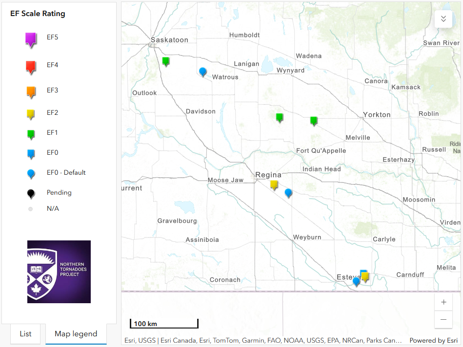
Regional map showing the locations of the tornadoes in SK from June 19.
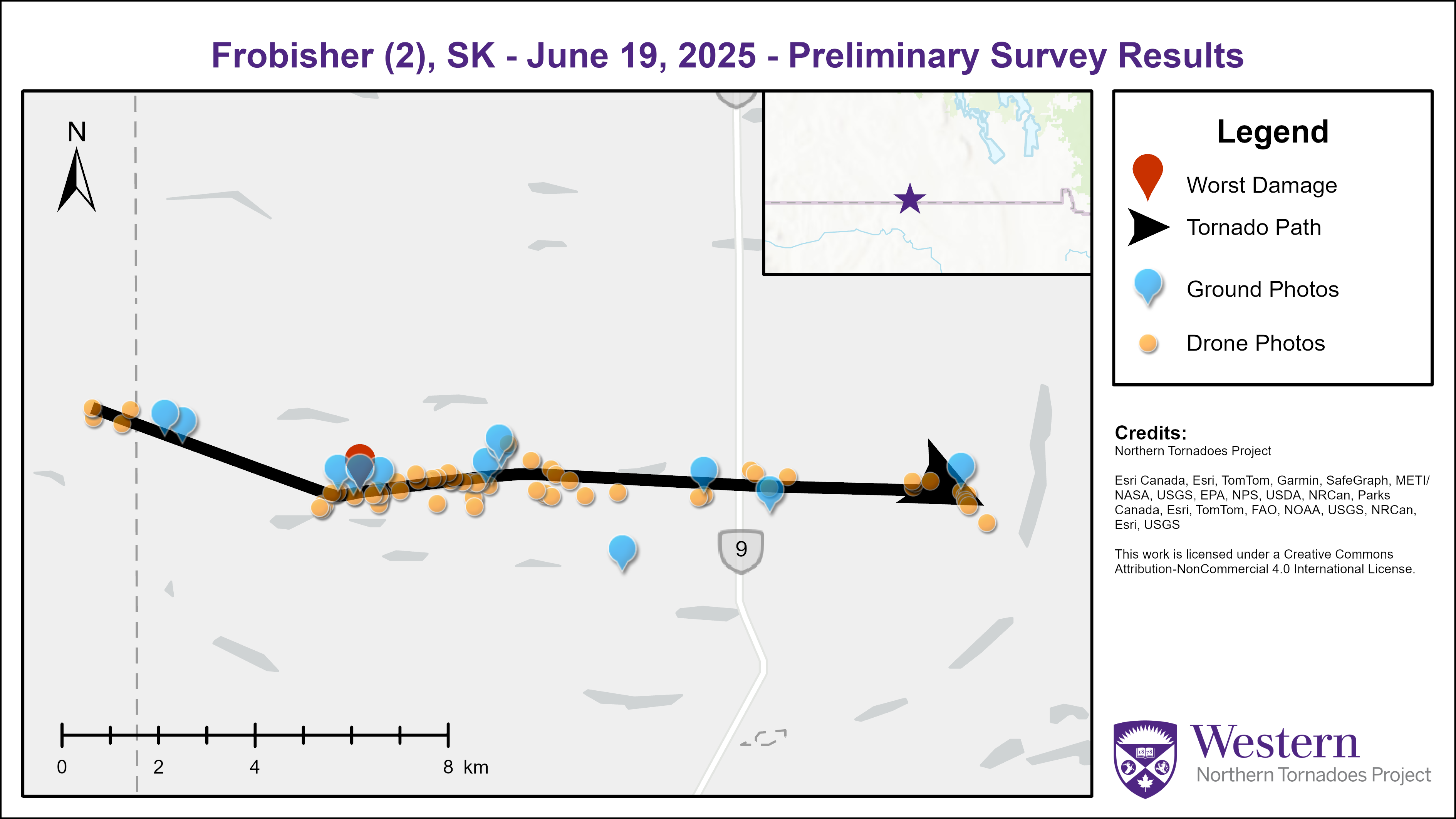
Survey summary map for the Frobisher (2) EF2 tornado.
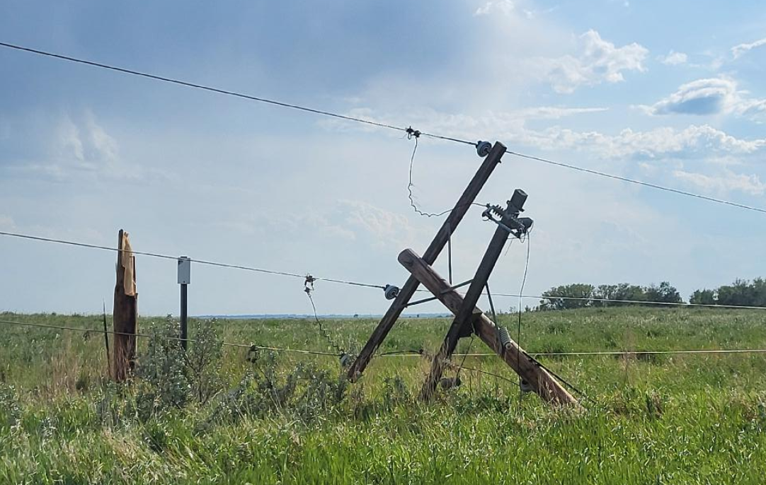
Photo from area of worst damage along the path of the Frobisher EF2 tornado showing one of numerous snapped power poles.
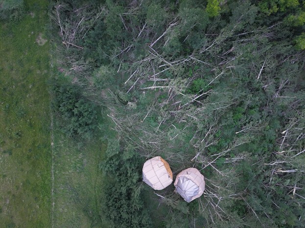
Drone image from area of worst damage along the path of the Frobisher EF2 tornado showing two grain bins that were rolled a long distance into a stand of trees that were also severely damaged by the tornado.
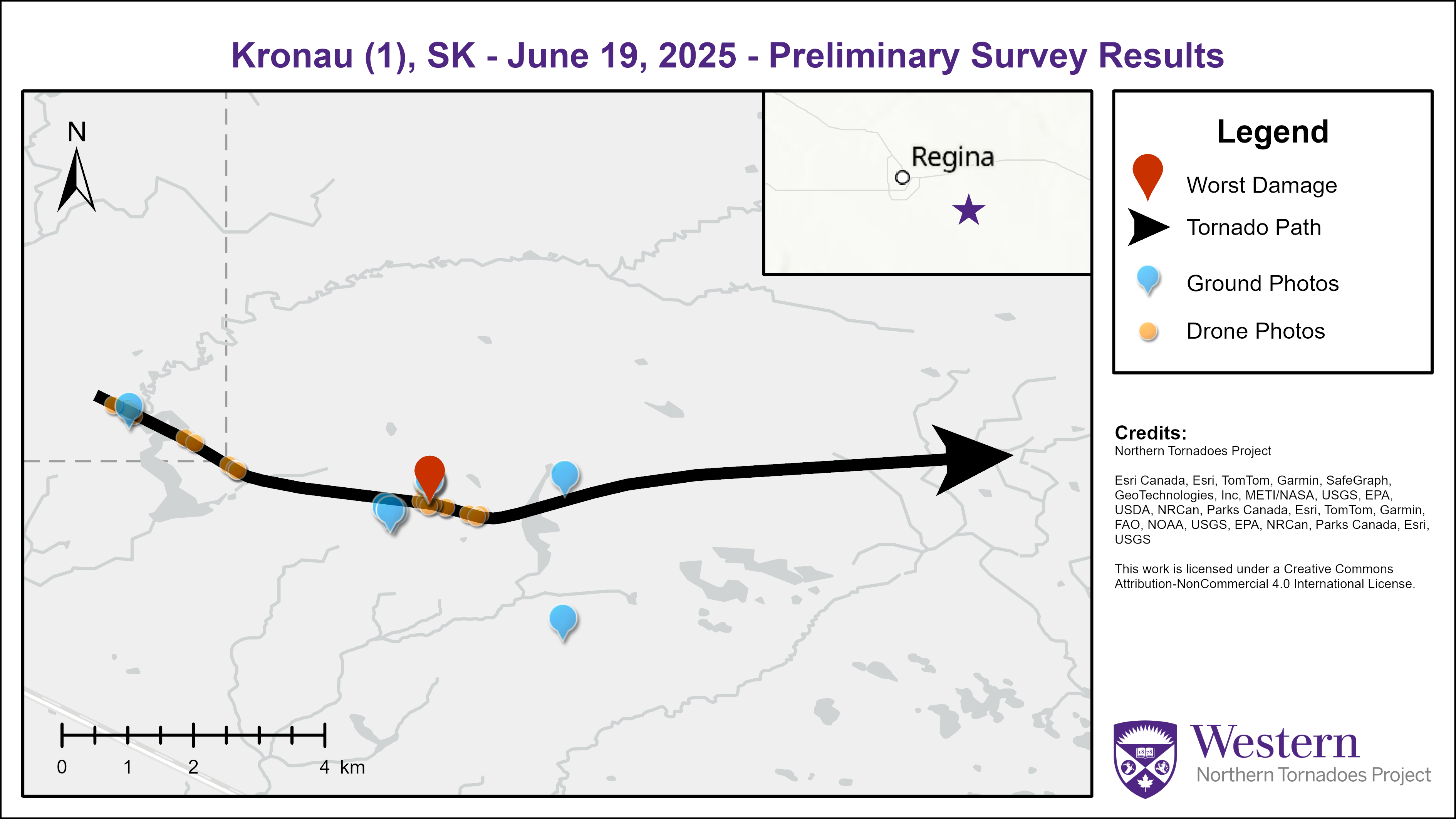
Survey summary map for the Kronau (1) EF2 tornado.
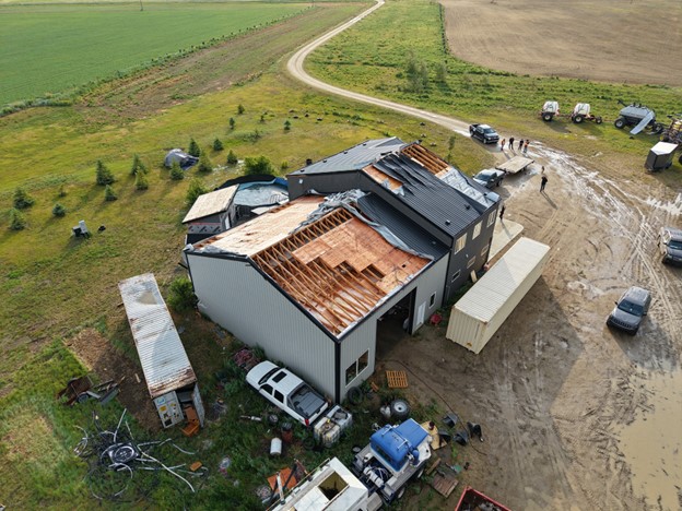
Drone image from the path of the Kronau EF2 tornado showing roof damage to a house that had hurricane clips (two sets) installed, resulting in an upper-bound wind speed estimate for this degree of damage. A shipping container (at left) was also thrown against the house causing damage.
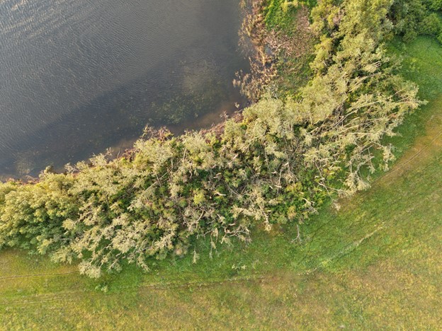
Drone image showing tree damage near the start of the damage path of the Kronau EF2 tornado.
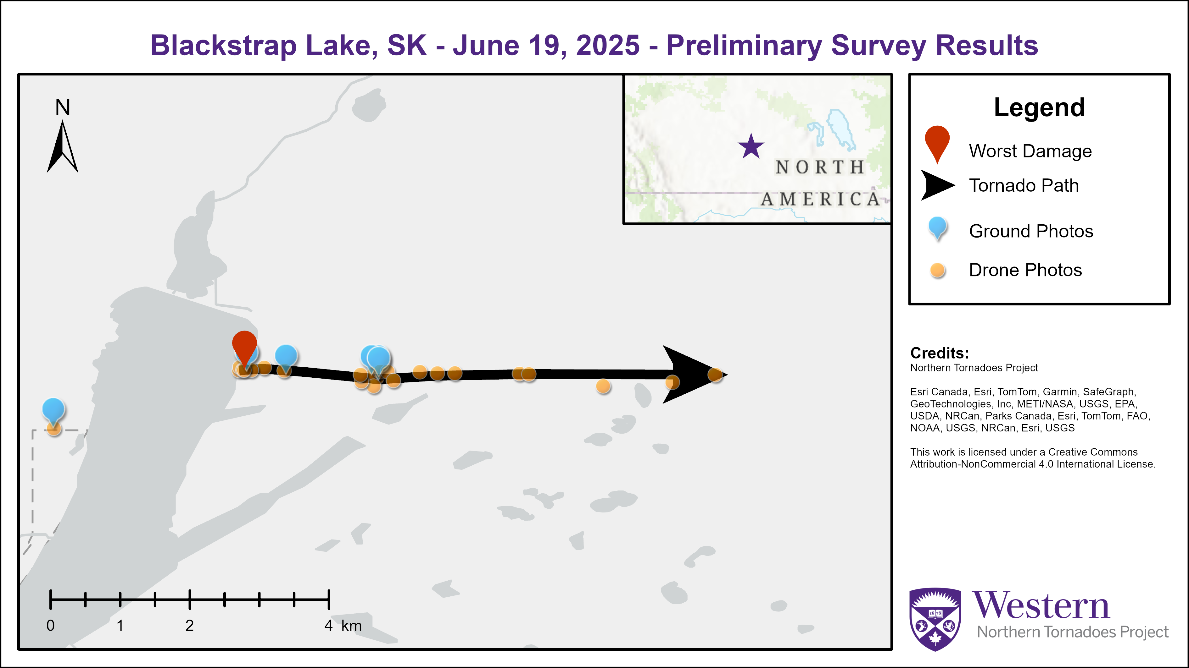
Survey summary map for the Blackstrap Lake EF1 tornado.
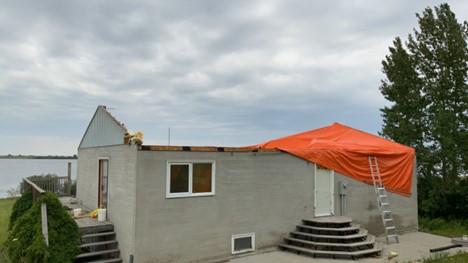
Photo of cabin with roof removed by the Blackstrap Lake EF1 tornado.
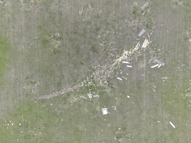
Drone image showing trail of debris downwind of the cabin that had its roof removed by the Blackstrap Lake EF1 tornado.
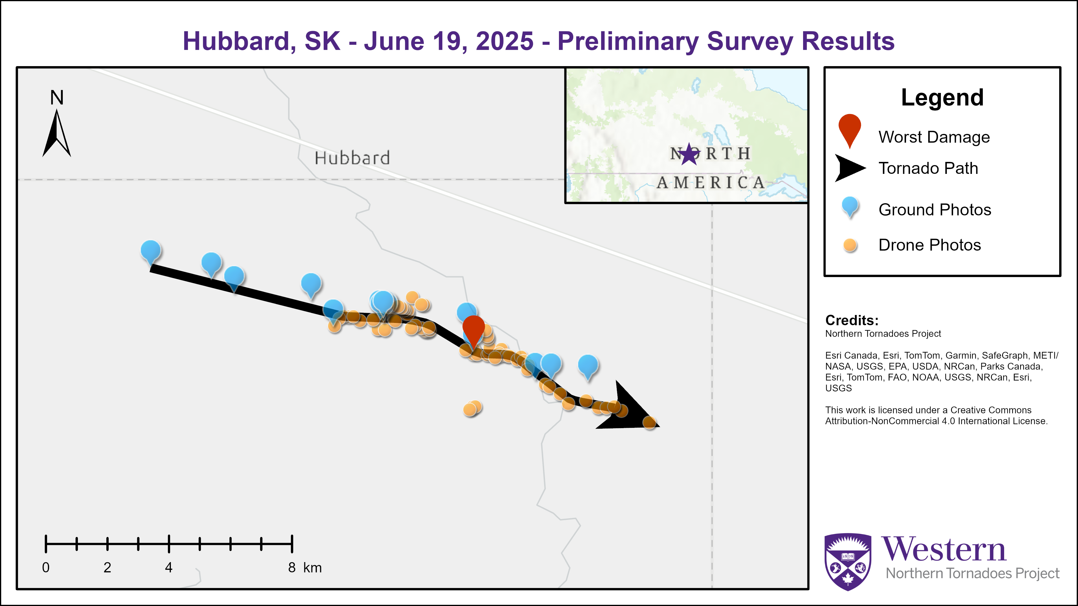
Survey summary map for the Hubbard EF1 tornado.
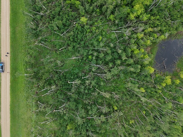
Drone image showing tree damage along the path of the Hubbard EF1 tornado.