Another 4 tornadoes in QC from June
The NTP has confirmed an additional four tornadoes based on satellite imagery review - one EF1 tornado from June 19, and one EF2 tornado / two EF1 tornadoes from June 23.
Details are provided in the summaries below, along with a regional map. The tornadoes can also be plotted using the NTP Dashboard here.
====
Event Name: Saint-Évariste-de-Forsyth, QC
Date: June 19, 2025
Start Time: 5:25 PM EDT (2125 UTC)
Final Classification: Tornado (Over Land)
Final EF-Scale Rating: EF1
EF-Scale Damage Indicator / Degree of Damage: C-T/DOD-5
Start of damage track: 45.9212N, 71.0092W
End of damage track: 45.9297N, 70.9167W
Location of worst damage: 45.9288N, 70.9213W
Description: Satellite imagery review of a storm track of interest revealed tornado damage in forested areas near Saint-Évariste-de-Forsyth. Tornado damage assessed as EF1, with an estimated max. wind speed of 145 km/h, track length of 7.26 km and max. path width of 120 m. Tornado motion was from the W (approx. 265 degrees). Start time is radar estimated.
Event Name: Lac de la Tête (La Tuque), QC
Date: June 23, 2025
Start Time: 5:00 PM EDT (2100 UTC)
Final Classification: Tornado (Over Land)
Final EF-Scale Rating: EF1
EF-Scale Damage Indicator / Degree of Damage: C-T/DOD-5
Start of damage track: 48.4647N, 75.4900W
End of damage track: 48.4546N, 75.4588W
Location of worst damage: 48.4599N, 75.4760W
Description: Satellite imagery review of a storm track of interest revealed tornado damage in forested areas at Lac de la Tête (near the Gouin Reservoir). Tornado damage assessed as EF1, with an estimated max. wind speed of 145 km/h, track length of 2.57 km and max. path width of 380 m. Tornado motion was from the WNW (approx. 295 degrees). Start time is estimated based on lightning data. Weak downburst damage was also visible beyond the end of the tornado track, near Baie Adolphe-Poisson (preliminary EF0 rating).
Event Name: Brécourt Lake (Senneterre), QC
Date: June 23, 2025
Start Time: 5:00 PM EDT (2100 UTC)
Final Classification: Tornado (Over Land)
Final EF-Scale Rating: EF2
EF-Scale Damage Indicator / Degree of Damage: C-T/DOD-6
Start of damage track: 48.3975N, 75.5880W
End of damage track: 48.3795N, 75.4484W
Location of worst damage: 48.3820N, 75.4755W
Description: Satellite imagery review of a storm track of interest revealed tornado damage in forested areas at Brécourt Lake (near the Gouin Reservoir). Tornado damage assessed as EF2, with an estimated max. wind speed of 190 km/h, track length of 10.6 km and max. path width of 680 m. Tornado motion was from the W (approx. 280 degrees). Start time is estimated based on lightning data. Downburst damage was also visible beyond the end of the tornado track, near Baie Mattawa (preliminary EF1 rating).
Event Name: Notre-Dame-du-Rosaire, QC
Date: June 23, 2025
Start Time: 9:35 PM EDT (0135 UTC)
Final Classification: Tornado (Over Land)
Final EF-Scale Rating: EF1
EF-Scale Damage Indicator / Degree of Damage: C-T/DOD-5
Start of damage track: 46.7757N, 70.4072W
End of damage track: 46.7786N, 70.3849W
Location of worst damage: 46.7770N, 70.3906W
Description: Satellite imagery review of a storm track of interest revealed tornado damage in forested areas south of Notre-Dame-du-Rosaire. Tornado damage assessed as EF1, with an estimated max. wind speed of 145 km/h, track length of 1.75 km and max. path width of 160 m. Tornado motion was from the W (approx. 260 degrees). Start time is radar estimated.
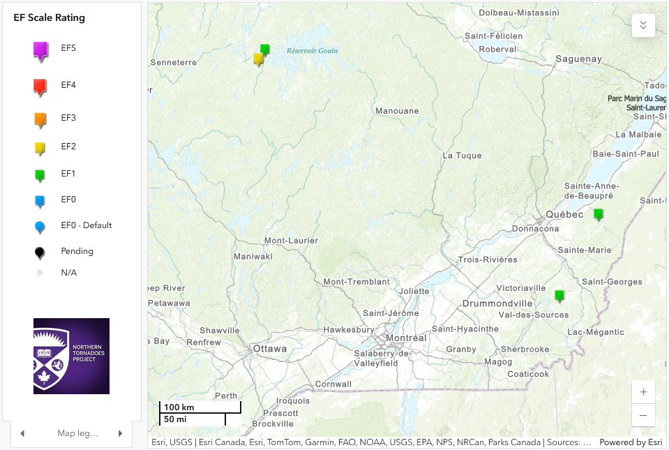
Regional map showing the locations of the one EF2 and three EF1 tornadoes in QC.