Six more tornadoes and a downburst cluster in Northern Ontario
NTP investigations have led to confirmations for six more tornadoes and a downburst cluster in Northern Ontario. All of these events were detected and assessed using high-resolution satellite imagery.
On September 17, tornadic supercells over NW ON resulted in two EF1 tornadoes and one EF2 tornado. A couple of months earlier, on June 18, a line of severe storms resulted in an EF2 tornado and an EF2 downburst cluster in NW ON. The next day, another line of severe storms in NE ON produced two EF1 tornadoes.
The details are provided in the event summaries below (in chronological order), along with a regional map and selected before/after satellite imagery animations. These events can also be plotted on a map via the NTP Dashboard here.
====
Event Name: Saganagons Lake, ON
Date: June 18, 2024
Start Time: 5:45 PM EDT (2145 UTC)
Final Classification: Tornado (Over Land)
Final EF-Scale Rating: EF2
EF-Scale Damage Indicator / Degree of Damage: C-T/DOD-6
Start of damage track: 48.3134N, 90.8860W
End of damage track: 48.3313N, 90.7916W
Location of worst damage: 48.3203N, 90.8558W
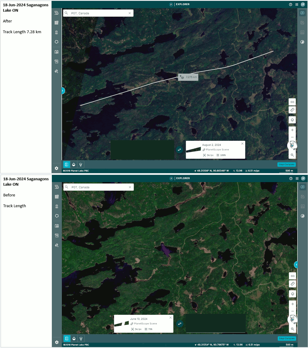
Description: Satellite imagery review of a storm track of interest revealed tornado damage in a forested areas east of Saganagons Lake. Damage assessed as EF2 tornado, with an estimated max. wind speed of 190 km/h, track length of 7.28 km and max. path width of 880 m. Tornado motion was from the WSW (approx. 255 degrees). Start time is radar estimated. Weak downburst damage was also observed at the end of the tornado track. As the storm progressed further east, downburst winds caused up to EF2 damage, with a visible damage swath approx. 62.5 km long and up to 8.5 km wide.
Event Name: Titmarsh Lake, ON
Date: June 18, 2024
Start Time: 5:55 PM EDT (2155 UTC)
Final Classification: Downburst
Final EF-Scale Rating: EF2
EF-Scale Damage Indicator / Degree of Damage: C-T/DOD-6
Location of worst damage: 48.3566N, 90.5886W
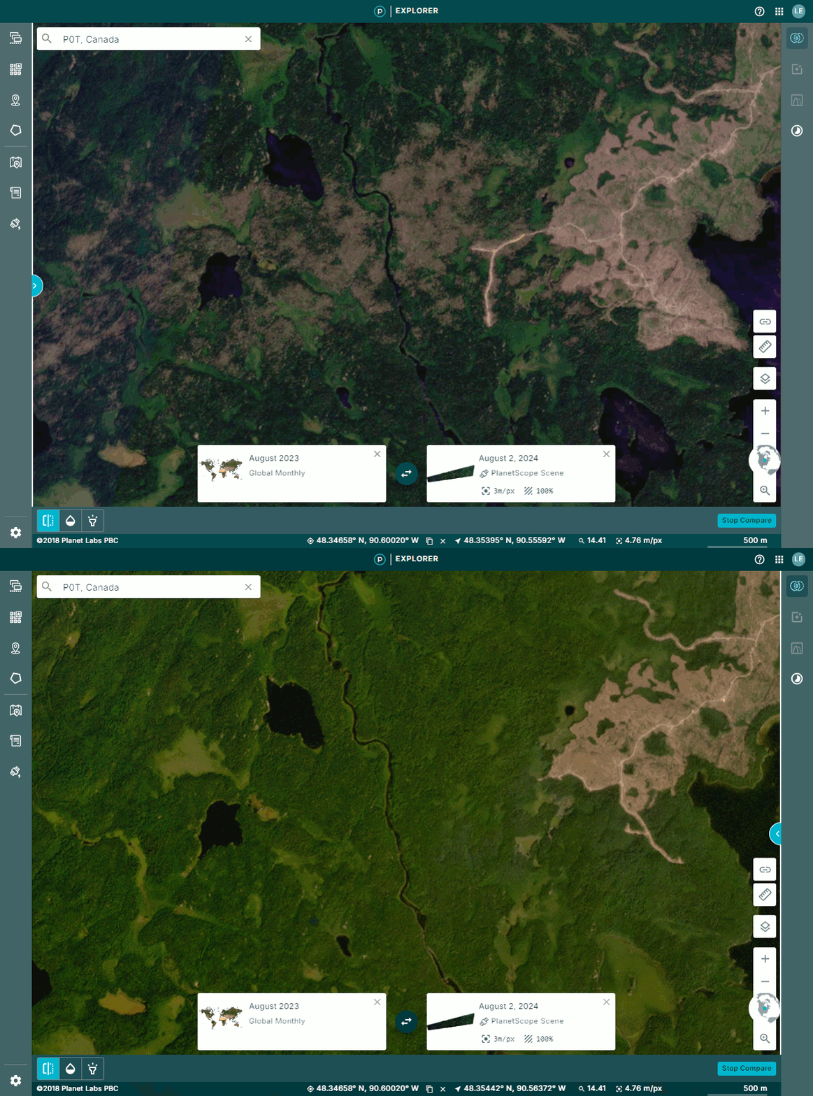
Description: Tree damage was reported at Batwing Lake after a storm passed through the area. Satellite imagery review of the storm track revealed a long stretch of visible downburst damage from Mowe Lake eastward, through the Batwing Lake area and ending south of Shabaqua (swath approx. 62.5 km long and up to 8.5 km across). The worst damage occurred near Titmarsh Lake. Damage assessed as EF2 downburst cluster, with an estimated max. wind speed of 190 km/h. Start time is radar estimated. The storm had previously produced an EF2 tornado further west at Saganagons Lake.
Event Name: Moseley Lake, ON
Date: June 19, 2024
Start Time: 2:55 PM EDT (1855 UTC)
Final Classification: Tornado (Over Land)
Final EF-Scale Rating: EF1
EF-Scale Damage Indicator / Degree of Damage: C-T/DOD-5
Start of damage track: 48.8730N, 80.6381W
End of damage track: 48.9165N, 80.5214W
Location of worst damage: 48.9126N, 80.5326W
Description: Satellite imagery review of a storm track of interest revealed tornado damage in a forested area near Moseley Lake (north of Iroquois Falls). Damage assessed as EF1 tornado, with an estimated max. wind speed of 170 km/h, track length of 10.0 km and max. path width of 280 m. Tornado motion was from the WSW (approx. 240 degrees). Start time is radar estimated. A second EF1 tornado later developed to the northeast of this tornado track near Bingle Lake.
Event Name: Bingle Lake, ON
Date: June 19, 2024
Start Time: 3:05 PM EDT (1905 UTC)
Final Classification: Tornado (Over Land)
Final EF-Scale Rating: EF1
EF-Scale Damage Indicator / Degree of Damage: C-T/DOD-5
Start of damage track: 48.9423N, 80.4917W
End of damage track: 48.9578N, 80.4504W
Location of worst damage: 48.9454N, 80.4784W
Description: Satellite imagery review of a storm track of interest revealed tornado damage in a forested area near Bingle Lake (northeast of Iroquois Falls). Damage assessed as EF1 tornado, with an estimated max. wind speed of 145 km/h, track length of 3.50 km and max. path width of 380 m. Tornado motion was from the WSW (approx. 240 degrees). Start time is radar estimated. An earlier EF1 tornado developed southwest of this tornado track near Moseley Lake.
Event Name: McIntyre Bay (Lac Seul), ON
Date: September 17, 2024
Start Time: 5:30 PM CDT (2230 UTC)
Final Classification: Tornado (Over Land)
Final EF-Scale Rating: EF2
EF-Scale Damage Indicator / Degree of Damage: C-T/DOD-6
Start of damage track: 50.3738N, 92.8428W
End of damage track: 50.3918N, 92.8135W
Location of worst damage: 50.3834N, 92.8342W
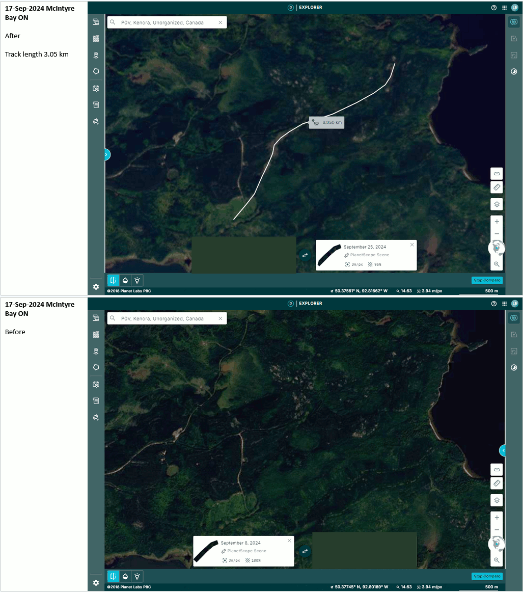
Description: Satellite imagery review of a storm track of interest revealed tornado damage in forested areas near McIntyre Bay (Lac Seul). Damage assessed as EF2 tornado, with an estimated max. wind speed of 190 km/h, track length of 3.05 km and max. path width of 190 m. Tornado motion was from the SW (approx. 230 degrees). Start time is radar estimated.
Event Name: Film Lake, ON
Date: September 17, 2024
Start Time: 5:55 PM CDT (2255 UTC)
Final Classification: Tornado (Over Land)
Final EF-Scale Rating: EF1
EF-Scale Damage Indicator / Degree of Damage: C-T/DOD-5
Start of damage track: 50.1079N, 92.8386W
End of damage track: 50.1285N, 92.8025W
Location of worst damage: 50.1192N, 92.8157W
Description: Satellite imagery review of a storm track of interest revealed tornado damage in forested areas near Film Lake (north of Dryden). Damage assessed as EF1 tornado, with an estimated max. wind speed of 145 km/h, track length of 3.49 km and max. path width of 150 m. Tornado motion was from the SW (approx. 230 degrees). Start time is radar estimated. A second EF1 tornado later developed to the northeast, near Morison Lake.
Event Name: Morison Lake, ON
Date: September 17, 2024
Start Time: 6:00 PM CDT (2300 UTC)
Final Classification: Tornado (Over Land)
Final EF-Scale Rating: EF1
EF-Scale Damage Indicator / Degree of Damage: C-T/DOD-5
Start of damage track: 50.1523N, 92.7759W
End of damage track: 50.1744N, 92.7590W
Location of worst damage: 50.1597N, 92.7687W
Description: Satellite imagery review of a storm track of interest revealed tornado damage in forested areas near Morison Lake (north of Dryden). Damage assessed as EF1 tornado, with an estimated max. wind speed of 145 km/h, track length of 2.73 km and max. path width of 180 m. Tornado motion was from the SSW (approx. 205 degrees). Start time is radar estimated. An earlier EF1 tornado developed to the southwest, near Film Lake.

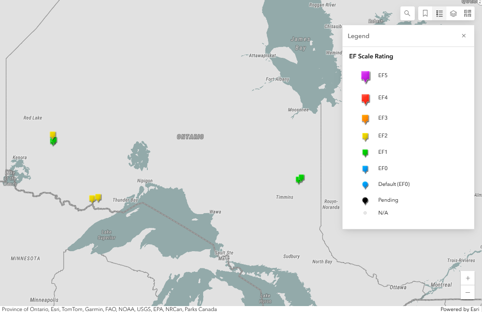
Regional maps showing the Jun 18, Jun 19 and Sep 17 tornadoes in Northern Ontario.

Animation showing before and after satellite images for the Jun 18 Saganagons Lake EF2 tornado.
Animation showing before and after satellite images for the Jun 18 EF2 downburst cluster with the worst damage at Titmarsh Lake.

Animation showing before and after satellite images for the Sep 17 McIntyre Bay EF2 tornado.
