More new tornadoes from the 2023 satellite review
As was mentioned in a blog post late last year, after the end of the storm season NTP conducts a thorough hi-res satellite review of all forested regions to see if there are any areas of wind damage that we missed. That review turned up nine new tornadoes for 2023.
But 27 new tornadoes from before 2023 were also discovered in the process: 12 for 2022, 6 for 2021, 2 in 2020, 2 in 2019, 4 in 2018 and 1 in 2017.
Five of the new tornadoes are rated EF2 while the rest are rated EF1. Some of these occurred as part of past outbreaks, including 18 Jun 2017 (EF2 in QC), 21 Sep 2018 (EF1 in QC), 10 Jun 2020 (EF1 in QC), and 5 Jul 2021 (EF2 in QC).
Below is a map showing the locations of all of the new tornadoes, as well as an updated tornado count graph.
Following that are event summaries for each of the 27 new tornadoes, listed in chronological order.
Note that you can also plot and view the new tornadoes using the NTP Dashboard at https://uwo.ca/ntp/dashboard.
====
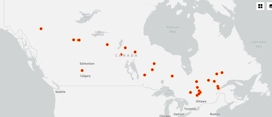
Map showing the locations of all 27 new tornadoes between 2017 and 2022.
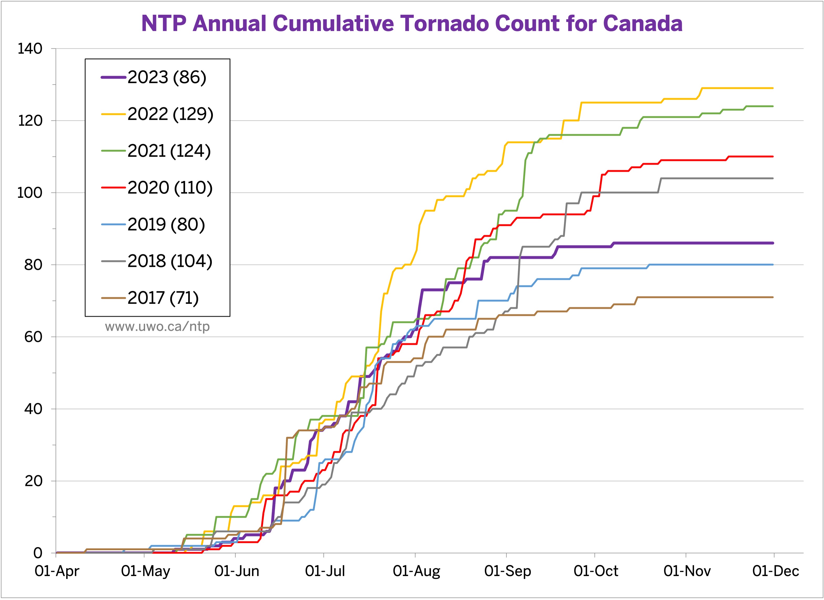
Updated annual cumulative tornado count chart.
Event Name: Lac du Castor (Le Fjord-du-Saguenay), QC
Date: June 18, 2017
Start Time: 5:40 PM EDT (2140 UTC)
Final Classification: Tornado (over land)
Final EF-Scale Rating: EF2
EF-Scale Damage Indicator / Degree of Damage: C-T/DOD-6
Start of damage track: 48.8477N, 70.1033W
End of damage track: 48.9441N, 69.9211W
Location of worst damage: 48.8731N, 70.0465W
Description: Satellite imagery review revealed a tornado damage path in forested areas near Lac du Castor (Le Fjord-du-Saguenay). Tornado damage assessed as EF2, with an estimated max. wind speed of 190 km/h, track length of 17.6 km and max. path width of 540 m. Tornado motion was from the SW (approx. 230 degrees). Start time is radar estimated.
Event Name: Lac Aubin-Tellier (Le Fjord-du-Saguenay), QC
Date: July 17, 2018
Start Time: 11:00 PM EDT (0300 UTC)
Final Classification: Tornado (over land)
Final EF-Scale Rating: EF1
EF-Scale Damage Indicator / Degree of Damage: C-T/DOD-5
Start of damage track: 51.4926N, 70.4994W
End of damage track: 51.4858N, 70.4762W
Location of worst damage: 51.4897N, 70.4900W
Description: Satellite imagery review revealed a tornado damage path in forested areas near Lac Aubin-Tellier (Le Fjord-du-Saguenay). Tornado damage assessed as EF1, with an estimated max. wind speed of 145 km/h, track length of 1.78 km and max. path width of 180 m. Tornado motion was from the WNW (approx. 295 degrees). Start time is estimated based on lightning data.
Event Name: Baldwinson Lakes, SK
Date: July 21, 2018
Start Time: 7:00 PM CST (0100 UTC)
Final Classification: Tornado (over land)
Final EF-Scale Rating: EF2
EF-Scale Damage Indicator / Degree of Damage: C-T/DOD-6
Start of damage track: 57.1891N, 106.8215W
End of damage track: 57.2895N, 106.7464W
Location of worst damage: 57.2614N, 106.7640W
Description: Satellite imagery review revealed a tornado damage path in forested areas near Baldwinson Lakes (south of Cree Lake). Tornado damage assessed as EF2, with an estimated max. wind speed of 190 km/h, track length of 12.1 km and max. path width of 1.35 km. Tornado motion was from the SSW (approx. 200 degrees). Start time is estimated based on lightning data.
Event Name: Misiwaweya Lake, ON
Date: August 25, 2018
Start Time: 6:00 PM CDT (2300 UTC)
Final Classification: Tornado (over land)
Final EF-Scale Rating: EF1
EF-Scale Damage Indicator / Degree of Damage: C-T/DOD-5
Start of damage track: 53.5971N, 91.2682W
End of damage track: 53.6249N, 91.1551W
Location of worst damage: 53.5980N, 91.2413W
Description: Satellite imagery review revealed a tornado damage path in forested areas near Misiwaweya Lake (southeast of Sachigo Lake). Tornado damage assessed as EF1, with an estimated max. wind speed of 170 km/h, track length of 8.28 km and max. path width of 390 m. Tornado motion was from the WSW (approx. 245 degrees). Start time is estimated based on lightning data.
Event Name: Petit lac Hertel (Maria-Chapdelaine), QC
Date: September 21, 2018
Start Time: 9:00 PM EDT (0100 UTC)
Final Classification: Tornado (over land)
Final EF-Scale Rating: EF1
EF-Scale Damage Indicator / Degree of Damage: C-T/DOD-5
Start of damage track: 50.1934N, 73.2371W
End of damage track: 50.2050N, 73.1838W
Location of worst damage: 50.2000N, 73.2166W
Description: Satellite imagery review revealed a tornado damage path in forested areas near Petit lac Hertel (Maria-Chapdelaine). Tornado damage assessed as EF1, with an estimated max. wind speed of 145 km/h, track length of 4.09 km and max. path width of 230 m. Tornado motion was from the WSW (approx. 250 degrees). Start time is estimated based on lightning data.
Event Name: Chutes-des-Passes, QC
Date: July 20, 2019
Start Time: 5:30 PM EDT (2130 UTC)
Final Classification: Tornado (over land)
Final EF-Scale Rating: EF1
EF-Scale Damage Indicator / Degree of Damage: C-T/DOD-5
Start of damage track: 49.9757N, 71.3170W
End of damage track: 49.9563N, 71.1955W
Location of worst damage: 49.9670N, 71.2665W
Description: Satellite imagery review revealed a tornado damage path in forested areas near Chutes-des-Passes. Tornado damage assessed as EF1, with an estimated max. wind speed of 145 km/h, track length of 8.98 km and max. path width of 310 m. Tornado motion was from the WNW (approx. 285 degrees). Start time is radar estimated.
Event Name: Lac à l'Anguille (Caniapiscau), QC
Date: September 23, 2019
Start Time: 12:15 AM EDT (0415 UTC)
Final Classification: Tornado (over land)
Final EF-Scale Rating: EF1
EF-Scale Damage Indicator / Degree of Damage: C-T/DOD-5
Start of damage track: 51.7756N, 68.7007W
End of damage track: 51.7777N, 68.6891W
Location of worst damage: 51.7769N, 68.6919W
Description: Satellite imagery review revealed a short tornado damage path in forested areas near Lac à l'Anguille (Caniapiscau). Tornado damage assessed as EF1, with an estimated max. wind speed of 145 km/h, track length of 830 m and max. path width of 230 m. Tornado motion was from the WSW (approx. 255 degrees). Start time is estimated based on lightning data.
Event Name: Lac Ava (Pontiac), QC
Date: June 10, 2020
Start Time: 11:00 PM EDT (0300 UTC)
Final Classification: Tornado (over land)
Final EF-Scale Rating: EF1
EF-Scale Damage Indicator / Degree of Damage: C-T/DOD-5
Start of damage track: 46.8502N, 76.9507W
End of damage track: 46.8919N, 76.8562W
Location of worst damage: 46.8898N, 76.8604W
Description: Satellite imagery review revealed a tornado damage path in forested areas near Lac Ava (Pontiac). Weak downburst damage is also visible at the end of the tornado track. Tornado damage assessed as EF1, with an estimated max. wind speed of 145 km/h, track length of 8.64 km and max. path width of 190 m. Tornado motion was from the SW (approx. 230 degrees). Start time is radar estimated.
Event Name: Lac Olga (Jamésie), QC
Date: July 7, 2020
Start Time: 12:45 PM EDT (1645 UTC)
Final Classification: Tornado (over land)
Final EF-Scale Rating: EF2
EF-Scale Damage Indicator / Degree of Damage: C-T/DOD-6
Start of damage track: 49.8996N, 77.1520W
End of damage track: 49.9103N, 77.0773W
Location of worst damage: 49.9017N, 77.1319W
Description: Satellite imagery review revealed a tornado damage path in forested areas near Lac Olga (Jamésie). Tornado damage assessed as EF2, with an estimated max. wind speed of 190 km/h, track length of 5.50 km and max. path width of 320 m. Tornado motion was from the W (approx. 260 degrees). Start time is radar estimated.
Event Name: Fernlund Lake, ON
Date: June 6, 2021
Start Time: 9:00 PM CDT (0200 UTC)
Final Classification: Tornado (over land)
Final EF-Scale Rating: EF1
EF-Scale Damage Indicator / Degree of Damage: C-T/DOD-5
Start of damage track: 52.3505N, 91.8715W
End of damage track: 52.3518N, 91.8121W
Location of worst damage: 52.3528N, 91.8510W
Description: Satellite imagery review revealed a tornado damage path in forested areas near Fernlund Lake. Tornado damage assessed as EF1, with an estimated max. wind speed of 145 km/h, track length of 4.06 km and max. path width of 460 m. Tornado motion was from the W (approx. 270 degrees). Start time is estimated based on lightning data.
Event Name: Lac Camachigama (Senneterre), QC
Date: July 15, 2021
Start Time: 7:24 PM EDT (2324 UTC)
Final Classification: Tornado (over land)
Final EF-Scale Rating: EF2
EF-Scale Damage Indicator / Degree of Damage: C-T/DOD-6
Start of damage track: 47.8437N, 76.3139W
End of damage track: 47.9122N, 76.1819W
Location of worst damage: 47.8781N, 76.2404W
Description: Satellite imagery review revealed a tornado damage path in forested areas near Lac Camachigama (Senneterre). Tornado damage assessed as EF2, with an estimated max. wind speed of 190 km/h, track length of 12.6 km and max. path width of 260 m. Tornado motion was from the SW (approx. 230 degrees). Start time is radar estimated.
Event Name: Chain Ponds (Keg River), AB
Date: August 15, 2021
Start Time: 5:15 PM MDT (2315 UTC)
Final Classification: Tornado (over land)
Final EF-Scale Rating: EF1
EF-Scale Damage Indicator / Degree of Damage: C-T/DOD-5
Start of damage track: 58.0485N, 117.9779W
End of damage track: 58.0621N, 117.8919W
Location of worst damage: 58.0493N, 117.9745W
Description: Satellite imagery review revealed a tornado damage path in forested areas near Chain Ponds (north of Keg River). Tornado damage assessed as EF1, with an estimated max. wind speed of 170 km/h, track length of 5.30 km and max. path width of 350 m. Tornado motion was from the WSW (approx. 255 degrees). Start time is estimated based on lightning data.
Event Name: Buffalo Head Prairie (1), AB
Date: August 15, 2021
Start Time: 6:15 PM MDT (0015 UTC)
Final Classification: Tornado (over land)
Final EF-Scale Rating: EF1
EF-Scale Damage Indicator / Degree of Damage: C-T/DOD-5
Start of damage track: 57.9737N, 116.4092W
End of damage track: 57.9740N, 116.2001W
Location of worst damage: 57.9773N, 116.2764W
Description: Satellite imagery review revealed a tornado damage path in forested areas south of Buffalo Head Prairie. Tornado damage assessed as EF1, with an estimated max. wind speed of 145 km/h, track length of 12.5 km and max. path width of 430 m. Tornado motion was from the W (approx. 270 degrees). Start time is estimated based on lightning data. A second tornado later developed southeast of Buffalo Head Prairie, starting approx. 5.2 km northeast of the end of this tornado.
Event Name: Buffalo Head Prairie (2), AB
Date: August 15, 2021
Start Time: 6:30 PM MDT (0030 UTC)
Final Classification: Tornado (over land)
Final EF-Scale Rating: EF1
EF-Scale Damage Indicator / Degree of Damage: C-T/DOD-5
Start of damage track: 58.0076N, 116.1381W
End of damage track: 58.0002N, 116.0287W
Location of worst damage: 58.0076N, 116.0754W
Description: Satellite imagery review revealed a tornado damage path in forested areas southeast of Buffalo Head Prairie. Tornado damage assessed as EF1, with an estimated max. wind speed of 145 km/h, track length of 6.66 km and max. path width of 210 m. Tornado motion was from the W (approx. 275 degrees). Start time is estimated based on lightning data. An earlier tornado developed south of Buffalo Head Prairie, ending approx. 5.2 km southwest this start point.
Event Name: Strachan, AB
Date: September 15, 2021
Start Time: 2:30 PM MDT (2030 UTC)
Final Classification: Tornado (over land)
Final EF-Scale Rating: EF1
EF-Scale Damage Indicator / Degree of Damage: C-T/DOD-5
Start of damage track: 52.2063N, 115.1115W
End of damage track: 52.2036N, 115.0612W
Location of worst damage: 52.2054N, 115.0985W
Description: Satellite imagery review revealed a tornado damage path in forested areas south of Strachan. Tornado damage assessed as EF1, with an estimated max. wind speed of 145 km/h, track length of 3.50 km and max. path width of 350 m. Tornado motion was from the W (approx. 275 degrees). Start time is radar estimated.
Event Name: Lac du Bec-Scie (La Vallée-de-la-Gatineau), QC
Date: July 24, 2022
Start Time: 8:48 PM EDT (0048 UTC)
Final Classification: Tornado (over land)
Final EF-Scale Rating: EF1
EF-Scale Damage Indicator / Degree of Damage: C-T/DOD-5
Start of damage track: 47.5114N, 75.9175W
End of damage track: 47.5130N, 75.8750W
Location of worst damage: 47.5127N, 75.9000W
Description: Satellite imagery review revealed a tornado damage path in forested areas near Lac du Bec-Scie (La Vallée-de-la-Gatineau). Tornado damage assessed as EF1, with an estimated max. wind speed of 145 km/h, track length of 3.21 km and max. path width of 180 m. Tornado motion was from the W (approx. 265 degrees). Start time is radar estimated.
Event Name: Ken Lake, BC
Date: July 31, 2022
Start Time: 5:00 PM PDT (0200 UTC)
Final Classification: Tornado (over land)
Final EF-Scale Rating: EF1
EF-Scale Damage Indicator / Degree of Damage: C-T/DOD-5
Start of damage track: 59.9133N, 128.7894W
End of damage track: 59.9194N, 128.6566W
Location of worst damage: 59.9148N, 128.7362W
Description: Satellite imagery review revealed a tornado damage path in forested areas near Ken Lake (west of Lower Post). Tornado damage assessed as EF1, with an estimated max. wind speed of 145 km/h, track length of 7.45 km and max. path width of 380 m. Tornado motion was from the W (approx. 265 degrees). Start time is estimated based on lightning data.
Event Name: Apussigamasi Lake, MB
Date: August 8, 2022
Start Time: 3:00 PM CDT (2000 UTC)
Final Classification: Tornado (over land)
Final EF-Scale Rating: EF1
EF-Scale Damage Indicator / Degree of Damage: C-T/DOD-5
Start of damage track: 55.8210N, 97.5620W
End of damage track: 55.8526N, 97.4511W
Location of worst damage: 55.8379N, 97.5168W
Description: Satellite imagery review revealed a tornado damage path in forested areas near Apussigamasi Lake (northeast of Thompson). Tornado damage assessed as EF1, with an estimated max. wind speed of 170 km/h, track length of 7.94 km and max. path width of 200 m. Tornado motion was from the WSW (approx. 245 degrees). Start time is estimated based on lightning data.
Event Name: Tryer Lakes, SK
Date: August 8, 2022
Start Time: 5:30 PM CST (2330 UTC)
Final Classification: Tornado (over land)
Final EF-Scale Rating: EF1
EF-Scale Damage Indicator / Degree of Damage: C-T/DOD-5
Start of damage track: 55.3149N, 102.1910W
End of damage track: 55.2763N, 101.9526W
Location of worst damage: 55.3127N, 102.1737W
Description: Satellite imagery review revealed a tornado damage path in forested areas near Tryer Lakes (south of Sandy Bay). Tornado damage assessed as EF1, with an estimated max. wind speed of 145 km/h, track length of 15.7 km and max. path width of 570 m. Tornado motion was from the WNW (approx. 285 degrees). Start time is estimated based on lightning data.
Event Name: Deuxième lac Félix (La Haute-Côte-Nord), QC
Date: August 31, 2022
Start Time: 2:27 AM EDT (0627 UTC)
Final Classification: Tornado (over land)
Final EF-Scale Rating: EF1
EF-Scale Damage Indicator / Degree of Damage: C-T/DOD-5
Start of damage track: 48.4633N, 69.9718W
End of damage track: 48.4801N, 69.9459W
Location of worst damage: 48.4669, 69.9658W
Description: Satellite imagery review revealed a tornado damage path in forested areas near Deuxième lac Félix (La Haute-Côte-Nord). Tornado damage assessed as EF1, with an estimated max. wind speed of 145 km/h, track length of 2.70 km and max. path width of 330 m. Tornado motion was from the SW (approx. 225 degrees). Start time is radar estimated.
Event Name: Lac du Vingt-Quatre (La Haute-Côte-Nord), QC
Date: August 31, 2022
Start Time: 2:33 AM EDT (0633 UTC)
Final Classification: Tornado (over land)
Final EF-Scale Rating: EF1
EF-Scale Damage Indicator / Degree of Damage: C-T/DOD-5
Start of damage track: 48.4797N, 69.9593W
End of damage track: 48.4954N, 69.9360W
Location of worst damage: 48.4876N, 69.9498W
Description: Satellite imagery review revealed a tornado damage path in forested areas near Lac du Vingt-Quatre (La Haute-Côte-Nord). Tornado damage assessed as EF1, with an estimated max. wind speed of 145 km/h, track length of 2.49 km and max. path width of 440 m. Tornado motion was from the SW (approx. 225 degrees). Start time is radar estimated.
Event Name: Lasthope Lake, MB
Date: September 1, 2022
Start Time: 5:00 PM CDT (2200 UTC)
Final Classification: Tornado (over land)
Final EF-Scale Rating: EF1
EF-Scale Damage Indicator / Degree of Damage: C-T/DOD-5
Start of damage track: 56.6244N, 100.7938W
End of damage track: 56.6393N, 100.6374W
Location of worst damage: 56.6284N, 100.7547W
Description: Satellite imagery review revealed a tornado damage path in forested areas near Lasthope Lake (southeast of Lynn Lake). Tornado damage assessed as EF1, with an estimated max. wind speed of 145 km/h, track length of 9.80 km and max. path width of 210 m. Tornado motion was from the WSW (approx. 260 degrees). Start time is estimated based on lightning data.
Event Name: Quantz Lake, ON
Date: September 20, 2022
Start Time: 10:45 PM EDT (0245 UTC)
Final Classification: Tornado (over land)
Final EF-Scale Rating: EF1
EF-Scale Damage Indicator / Degree of Damage: C-T/DOD-5
Start of damage track: 51.0683N, 85.2587W
End of damage track: 51.0616N, 85.1853W
Location of worst damage: 51.0632N, 85.1975W
Description: Satellite imagery review revealed a tornado damage path in forested areas near Quantz Lake (northwest of Hearst). Tornado damage assessed as EF1, with an estimated max. wind speed of 170 km/h, track length of 5.20 km and max. path width of 370 m. Tornado motion was from the W (approx. 275 degrees). Start time is estimated based on lightning data.
Event Name: Young Lake (Kenora), ON
Date: October 24, 2022
Start Time: 2:25 PM CDT (1925 UTC)
Final Classification: Tornado (over land)
Final EF-Scale Rating: EF1
EF-Scale Damage Indicator / Degree of Damage: C-T/DOD-5
Start of damage track: 51.2907N, 94.3889W
End of damage track: 51.4545N, 94.2810W
Location of worst damage: 51.3671N, 94.3448W
Description: Satellite imagery review revealed a tornado damage path in forested areas near Young Lake (Kenora). Tornado damage assessed as EF1, with an estimated max. wind speed of 145 km/h, track length of 20.0 km and max. path width of 450 m. Tornado motion was from the SSW (approx. 200 degrees). Start time is estimated based on lightning data.
Event Name: Angliers, QC
Date: November 5, 2022
Start Time: 11:00 PM EDT (0300 UTC)
Final Classification: Tornado (over land)
Final EF-Scale Rating: EF2
EF-Scale Damage Indicator / Degree of Damage: C-T/DOD-6
Start of damage track: 47.4938N, 79.2177W
End of damage track: 47.6164N, 79.0686W
Location of worst damage: 47.5133N, 79.1943W
Description: Satellite imagery review revealed a tornado damage path in forested areas near Angliers. Tornado damage assessed as EF2, with an estimated max. wind speed of 190 km/h, track length of 18.4 km and max. path width of 320 m. Tornado motion was from the SW (approx. 220 degrees). Start time is radar estimated.
Event Name: Lac Parent (Senneterre), QC
Date: November 6, 2022
Start Time: 1:30 AM EDT (0530 UTC)
Final Classification: Tornado (over land)
Final EF-Scale Rating: EF1
EF-Scale Damage Indicator / Degree of Damage: C-T/DOD-5
Start of damage track: 48.6514N, 76.9168W
End of damage track: 48.7436N, 76.7903W
Location of worst damage: 48.7162N, 76.8242W
Description: Satellite imagery review revealed a tornado damage path in forested areas near Lac Parent (Senneterre). Tornado damage assessed as EF1, with an estimated max. wind speed of 145 km/h, track length of 14.2 km and max. path width of 590 m. Tornado motion was from the SW (approx. 220 degrees). Start time is radar estimated.
Event Name: Lac de la Paroi (La Vallée-de-la-Gatineau), QC
Date: November 6, 2022
Start Time: 1:45 AM EST (0645 UTC)
Final Classification: Tornado (over land)
Final EF-Scale Rating: EF1
EF-Scale Damage Indicator / Degree of Damage: C-T/DOD-5
Start of damage track: 47.2187N, 76.3817W
End of damage track: 47.2391N, 76.3462W
Location of worst damage: 47.2257N, 76.3653W
Description: Satellite imagery review revealed a tornado damage path in forested areas near Lac de la Paroi (La Vallée-de-la-Gatineau). Tornado damage assessed as EF1, with an estimated max. wind speed of 145 km/h, track length of 3.54 km and max. path width of 330 m. Tornado motion was from the SW (approx. 230 degrees). Start time is radar estimated.