Tornadoes at Ottawa and Mirabel
An NTP investigation has concluded that two tornadoes occurred in the Barrhaven area of Ottawa, ON. An NTP ground/drone survey found a main path of damage that extends approximately 5 km with a maximum width of 200 m. A second shorter damage path that crosses the main path, approximately 1 km in length with a maximum width of 150 m, was caused by an slightly earlier tornado. This is supported by several videos from the area.
In both cases, residences had roof damage that included some structural failures, among other damage such as trees down and windows broken. Based on the structural damage, a maximum wind speed of 155 km/h hour was estimated, which falls in the EF1 categeory on the EF scale. That applies to both tornadoes. Note that length and width values for each tornado are preliminary as additional photo and video evidence is still being received and further analysis is required.
In Quebec, a tornado was confirmed by airport weather station observers at the Montréal–Mirabel International Airport. No damage has been investigated with this tornado at this time, so an EF scale rating is pending.
The NTP ground/drone survey team will continue to investigate areas of damage in Ontario and Quebec this weekend.
Event summaries for the Barrhaven and Mirabel tornadoes are provided below along with maps and images for the Barrhaven tornadoes.
====
Event Name: Barrhaven (1), ON
Date: July 13, 2023
Start Time: 12:44 PM EDT (1644 UTC)
Final Classification: Tornado (over land)
Final EF-Scale Rating: EF1
EF-Scale Damage Indicator / Degree of Damage: FR12/DOD-4
Preliminary start of tornado track: 45.2654N, 75.7598W
Preliminary end of tornado track: 45.2736N, 75.7514W
Preliminary location of worst damage: 45.2655N, 75.7594W
Description: Witnesses captured video and photos of two tornadoes that developed in the Barrhaven suburb of Ottawa, causing damage to dozens of homes and injuring one person. An NTP ground and drone survey was completed on July 14, 2023, documenting damage in the area and identifying two damage swaths. Investigation into both tornado tracks will continue, with preliminary results indicating both tornadoes caused EF1 damage with estimated max. wind speeds of 155 km/h. The preliminary track length for the first tornado is 1.13 km and max. path width is 150 m. Tornado motion was from the SW (approx. 215 degrees). Further investigation pending, including review of witness video, drone survey imagery and satellite imagery.
Event Name: Barrhaven (2), ON
Date: July 13, 2023
Start Time: 12:45 PM EDT (1645 UTC)
Final Classification: Tornado (over land)
Final EF-Scale Rating: EF1
EF-Scale Damage Indicator / Degree of Damage: FR12/DOD-4
Preliminary start of tornado track: 45.2451N, 75.7519W
Preliminary end of tornado track: 45.2869N, 75.7646W
Preliminary location of worst damage: 45.2516N, 75.7510W
Description: Witnesses captured video and photos of two tornadoes that developed in the Barrhaven suburb of Ottawa, causing damage to dozens of homes and injuring one person. An NTP ground and drone survey was completed on July 14, 2023, documenting damage in the area and identifying two damage swaths. Investigation into both tornado tracks will continue, with preliminary results indicating both tornadoes caused EF1 damage with estimated max. wind speeds of 155 km/h. The preliminary track length for the second tornado is 4.92 km and max. path width is 200 m. Tornado motion was from the S (approx. 170 degrees). Further investigation pending, including review of witness video, drone survey imagery and satellite imagery.
Event Name: Mirabel, QC
Date: July 13, 2023
Start Time: 3:23 PM EDT (1923 UTC)
Final Classification: Tornado (over land)
Preliminary EF-Scale Rating: Pending
Estimated tornado location: 45.70N, 74.07W
Description: A meteorological observer at the Montréal–Mirabel International Airport reported a tornado near the airport. Tree and structural damage was reported near Sainte-Jerome and Sainte-Anne-des-Plaines, but it is not known if it was associated with the reported tornado. An NTP ground and drone survey will be completed on July 15, 2023. Further investigation also includes satellite imagery review.
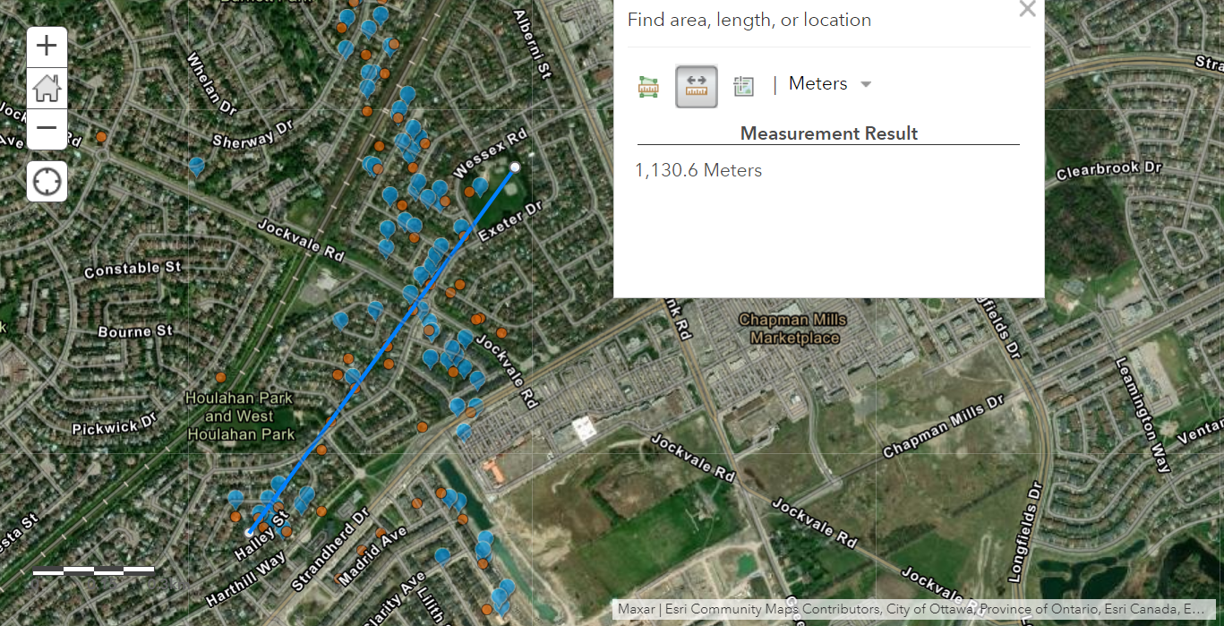
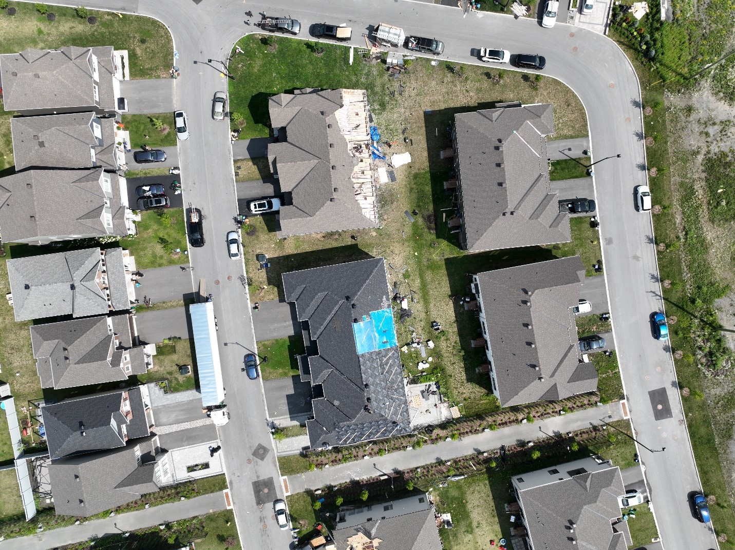
Map showing preliminary track and length of the Barrhaven (1) tornado - blue dots are where ground photos were taken, orange dots are where drone imagery was taken.
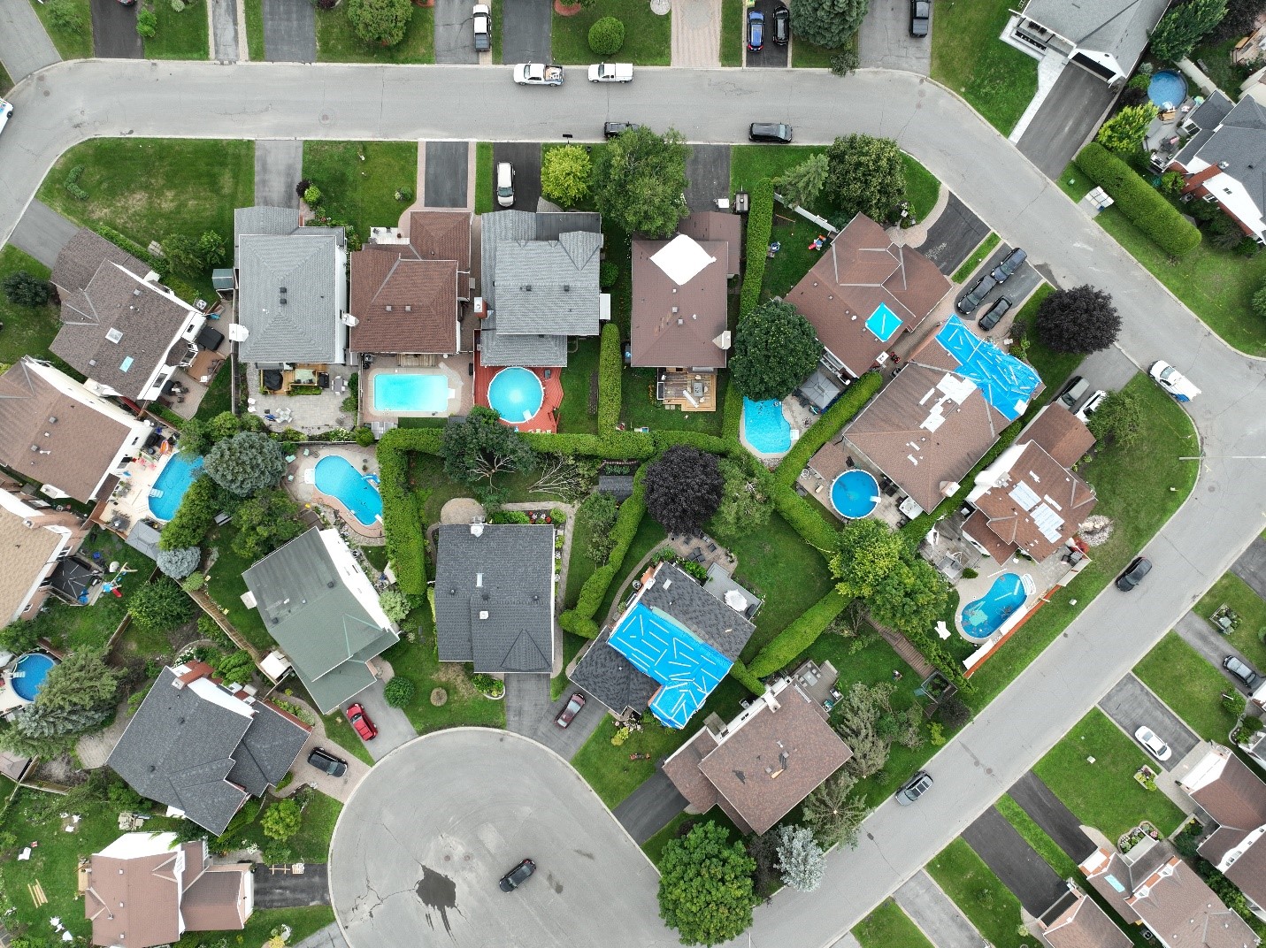
Worst damage at start of Barrhaven (1) track on Halley Street (FR12 – DOD4).
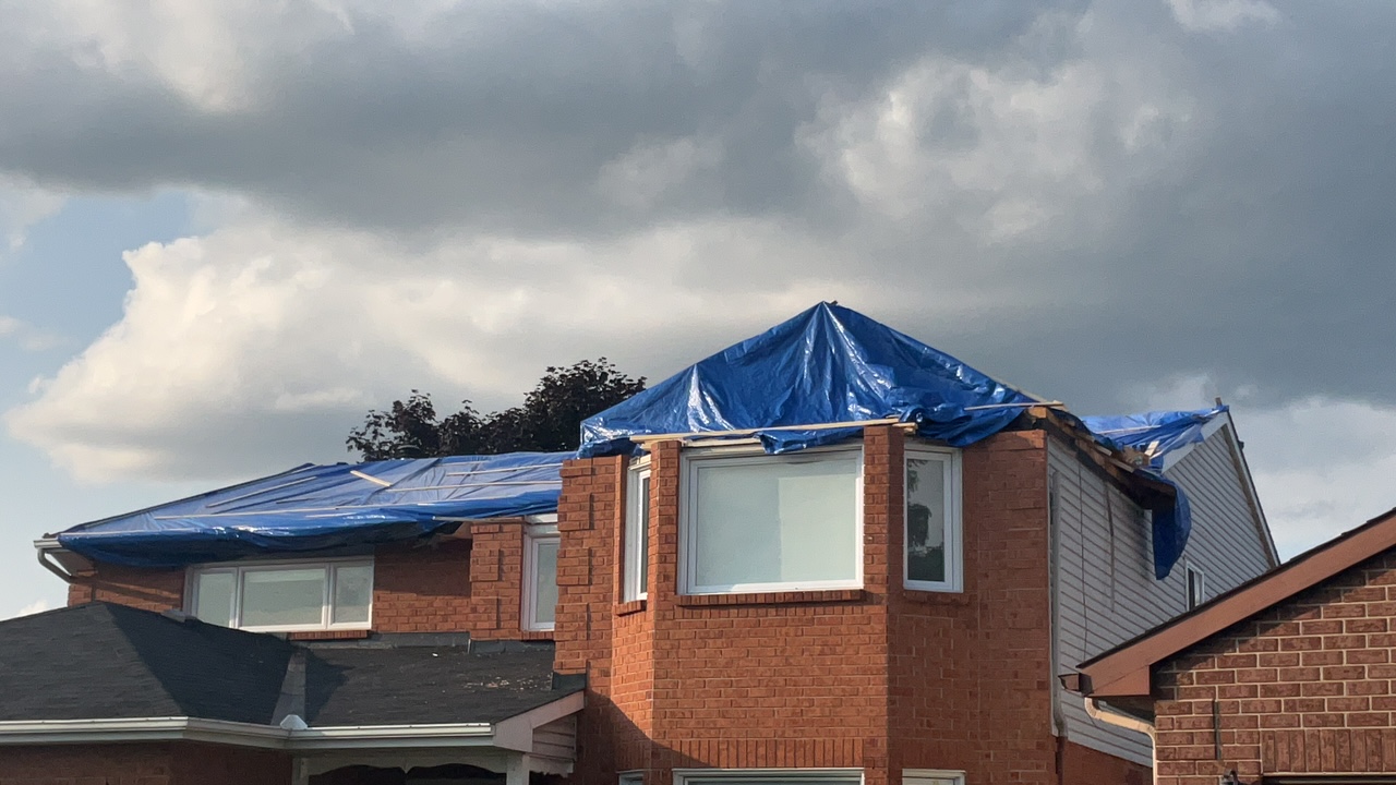
Ground photo with some of the roof damage from the drone image (there is structural damage under the tarps).
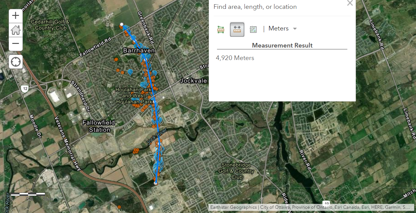
Map showing preliminary track and length of the Barrhaven (2) tornado - blue dots are where ground photos were taken, orange dots are where drone imagery was taken.
Worst damage from Barrhaven (2) tornado on Regulus Ridge in first third of the track (FR12-DOD4).
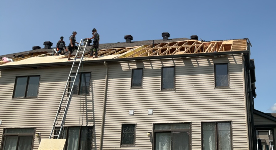
Ground photo with some of the roof damage from the drone image.
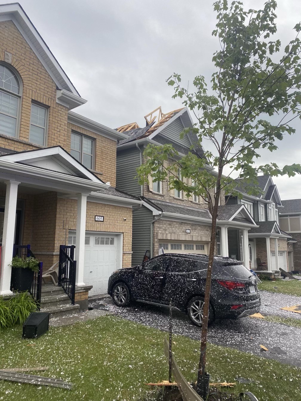
Photo from the evening of the event by Redditor Time_Chemistry5230 showing roof structure damage on Perseus Avenue. Note that blown-in insulation is stuck to nearly everything - a common sight when a tornado causes roof damage in new subdivisions. Used with permission.