Three microbursts in SW Ontario
An NTP investigation has led to three microbursts being confirmed in SW Ontario related to a series of strong storms through the area on July 14th. An NTP ground/drone survey team investigated three damage locations near Petrolia and Wallaceburg on July 16th. In each case, the damaging winds were focused over an area several kilometres in diameter and occurred with heavy rain and hail. All damage indicators suggested winds from between west and north, while the motion of the storms was from the northwest and toward the southeast. Detailed summary information, a map and some images from the surveys are provided below.
====
Event Name: Oil City, ON
Date: July 14, 2023
Time: 5:15 PM EDT (2115 UTC)
Final Classification: Downburst (Microburst)
Final EF-Scale Rating: EF0
EF-Scale Damage Indicator / Degree of Damage: SBO/DOD-5
Location of worst damage: 42.8336N 82.1153W
Description: Damage to a large machine shed and tree damage was reported in the Oil City area after a storm passed through. No injuries were reported. An NTP ground and drone survey was completed on July 16, 2023, documenting the damage. Damage assessed as EF0 downburst (microburst), with an estimated max. wind speed of 125 km/h. Satellite imagery review is pending. Event time is radar estimated.
Event Name: Whitebread, ON
Date: July 14, 2023
Time: 6:30 PM EDT (2230 UTC)
Final Classification: Downburst (Microburst)
Final EF-Scale Rating: EF1
EF-Scale Damage Indicator / Degree of Damage: C-ETL/DOD-4
Location of worst damage: 42.6187N, 82.4570W
Description: Several snapped power poles were reported near Whitebread (northwest of Wallaceburg) after a storm passed through the area. No injuries were reported. An NTP ground and drone survey was completed on July 16, 2023, documenting the pole damage along with minor roof damage to a home and tree damage. Damage assessed as EF1 downburst (microburst), with an estimated max. wind speed of 145 km/h. Satellite imagery review is pending. Event time is radar estimated.
Event Name: Wallaceburg, ON
Date: July 14, 2023
Time: 6:45 PM EDT (2245 UTC)
Final Classification: Downburst (Microburst)
Final EF-Scale Rating: EF0
EF-Scale Damage Indicator / Degree of Damage: SRB/DOD-2
Location of worst damage: 42.5745N, 82.3806W
Description: Tree damage was reported in Wallaceburg after a storm passed through the area. No injuries were reported. An NTP ground survey was completed on July 16, 2023, documenting the tree damage along with minor roof damage to a retail building. Damage assessed as EF0 downburst (microburst), with an estimated max. wind speed of 125 km/h. Satellite imagery review is pending. Event time is radar estimated.
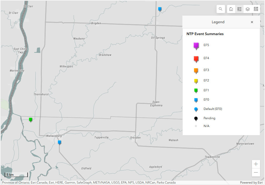
Map showing the locations of the three microburst events in SW Ontario.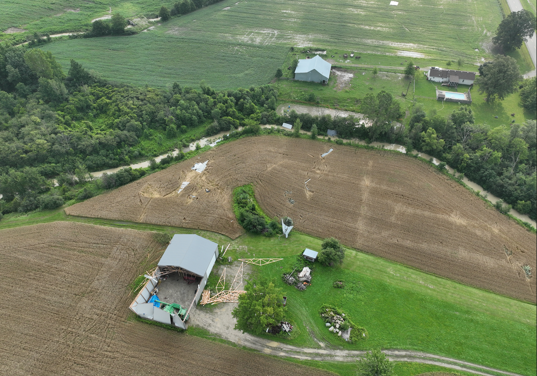
Drone photo of worst damage in Oil City area - lower bound of DOD5 (125 km/h) was used due to quality of construction and lack of significant damage to surrounding DIs.
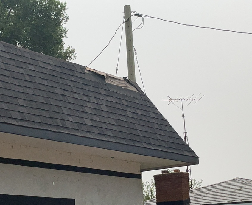
Despite a number of trees in Wallaceburg being snapped and uprooted (a good portion with rot), the highest-rated damage was actually to the roof of a small retail building.
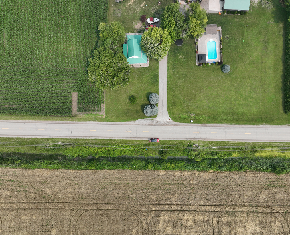
Drone view of two of the 10 power poles that were replaced near Whitebread, with pieces of the original poles still there. The tree just west of the house had a number of large branches broken off. The wheat to the south can be seen to be down from the north (as were the power poles).