Tecumseh tornado update and new Cottam tornado
NTP investigation has resulted in an update to the August 24 Tecumseh EF1 tornado and a new EF1 tornado near Cottam, ON on August 24, starting just east of the end point of the Tecumseh tornado and associated with the same storm. Additional ground/drone survey work by an NTP team filled in some gaps in the damage path for the Tecumseh tornado and found a new damage path extending to the northeast of Leamington.Details are provide in the event summaries below, along with maps and photos from the surveys. Event information can also be viewed and plotted via the NTP Dashboard at https://uwo.ca/ntp/dashboard.
====
Event Name: Tecumseh, ON (updates in italics)
Date: August 24, 2023
Start Time: 10:30 PM EDT (0230 UTC)
Final Classification: Tornado (over land)
Final EF-Scale Rating: EF1
EF-Scale Damage Indicator / Degree of Damage: SBO/DOD-6
Start of damage track: 42.3249N, 82.8731W
End of damage track: 42.1639N, 82.7195W
Location of Worst Damage: 42.2778N, 82.8355W
Description: Damage was reported in Tecumseh and southeastward to the Woodslee area after a storm passed though. Several homes and barns were damaged, along with power poles and trees. No injuries were reported. An NTP ground and drone survey was completed on August 26-28, 2023, documenting the reported damage along with crop damage. Damage assessed as EF1 tornado, with an estimated max. wind speed of 145 km/h, track length of 22.0 km and max. path width of 1.05 km. Tornado motion was from the NW (approx. 325 degrees). Satellite imagery review is pending. Start time is based on radar. A second tornado developed further east as this tornado dissipated, starting northeast of Cottam and causing up to EF1 damage as it tracked southeastward before dissipating in the Leamington area.
Event Name: Cottam, ON
Date: August 24, 2023
Start Time: 10:45 PM EDT (0245 UTC)
Final Classification: Tornado (over land)
Final EF-Scale Rating: EF1
EF-Scale Damage Indicator / Degree of Damage: FR12/DOD-4
Start of damage track: 42.1631N, 82.6969W
End of damage track: 42.0752N, 82.5848W
Location of Worst Damage: 42.1111N, 82.6456W
Description: Damage was reported northeast of Cottam and southeastward toward the Leamington area after a storm passed though. Several homes and barns were damaged, along with power poles and trees. No injuries were reported. An NTP ground and drone survey was completed on August 26-28, 2023, documenting the reported damage along with crop damage. Damage assessed as EF1 tornado, with an estimated max. wind speed of 145 km/h, track length of 13.8 km and max. path width of 670 m. Tornado motion was from the NW (approx. 315 degrees). Satellite imagery review is pending. Start time is based on radar. This tornado developed east of the end point of the Tecumseh EF1 tornado.
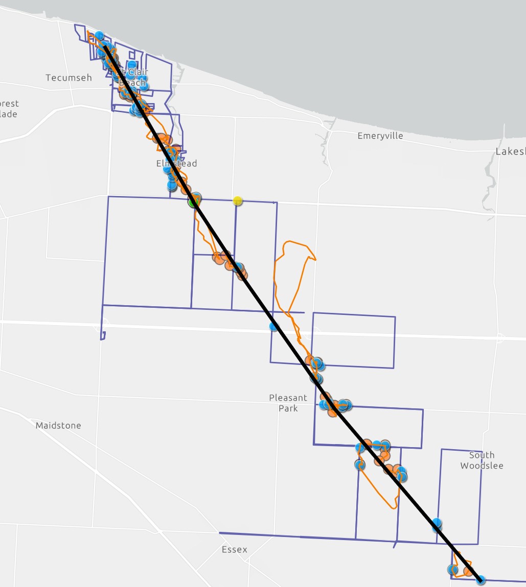
Updated map for the Tecumseh tornado showing locations of ground (blue) and drone (orange) photos, drone flight paths (orange lines) and the survey route (blue lines). The black line is the preliminary centreline of the tornado, with motion from top-left to bottom-right. See original blog post for other images.
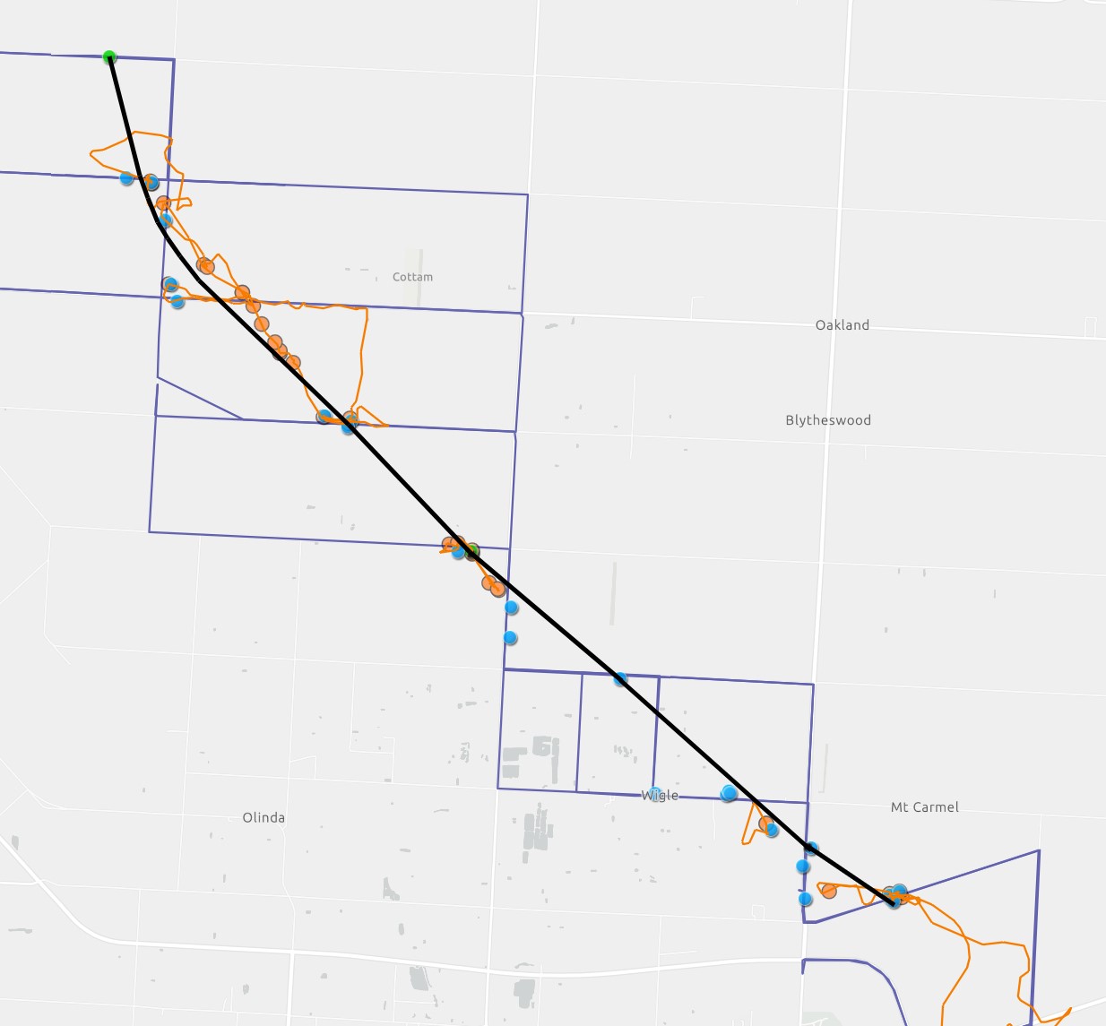
Map for the Cottam tornado showing locations of ground (blue) and drone (orange) photos, drone flight paths (orange lines) and the survey route (blue lines). The black line is the preliminary centreline of the tornado, with motion from top-left to bottom-right.

Home east of Cottam that suffered collapse of the porch gable (FR12/DOD-4), with debris in backyard.
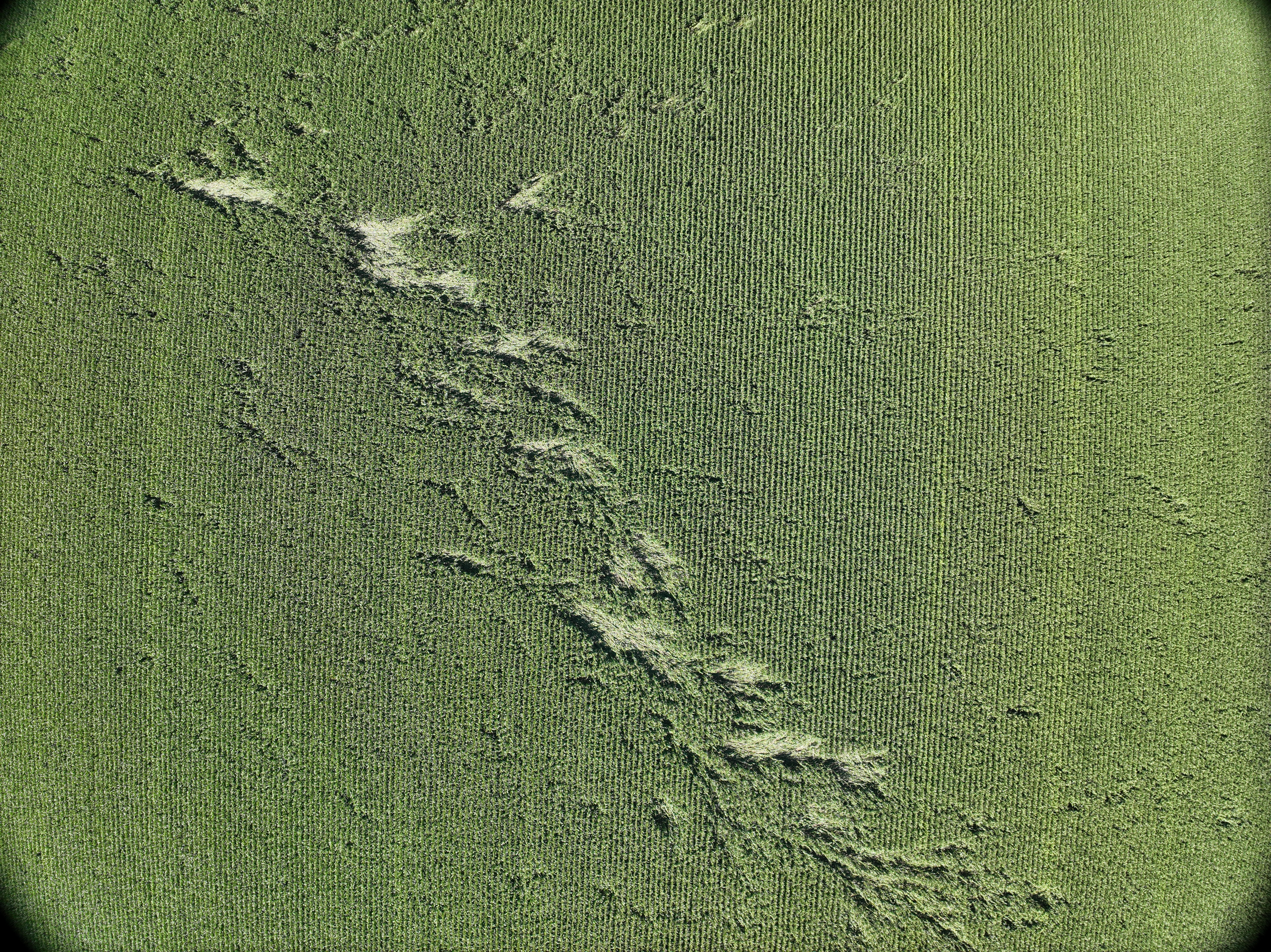
Drone image of crop damage along the path of the Cottom tornado. The directions of the fallen corn stalks show evidence of cross-path winds, and subtle curvature, associated with the cyclonic tornado (counter-clockwise rotation when viewing from above). The tornado was moving from the top-left of the image to toward the bottom-right.