Newly discovered 2021 tornadoes
Continuing NTP investigations have resulted in the discovery of an additional 17 tornadoes for 2021. The storms that produced these tornadoes had not been tracked by NTP and no damage reports were received. The damage paths were found while doing a systematic satellite review using high-resolution satellite imagery. The events all occurred in heavily forested areas from western SK to southern QC, with ratings from EF1 to EF2.
The addition of these 17 tornadoes increases the 2021 tornado count from 100 to 117 - which is coincidentally the same overall count for 2022.
See below for detailed summaries, a map showing the locations of the new events, and satellite imagery from two of the EF2 events.
===
SK tornadoes
Event Name: Limestone Lake, SK
Date: July 22, 2021
Start Time: 5:45 PM CST (2345 UTC)
Final Classification: Tornado (Over Land)
Final EF-Scale Rating: EF2
EF-Scale Damage Indicator / Degree of Damage: C-T/DOD-6
Start of damage track: 54.6550N, 103.1594W
End of damage of track: 54.6994N, 102.9625W
Location of worst damage: 54.6703N, 103.1050W
Description: Satellite imagery review revealed a tornado damage path in forested areas near Deschambault Lake. Tornado damage assessed as EF2, with an estimated max. wind speed of 190 km/h, track length of 13.8 km and max. path width of 1100 m. Tornado motion was from the WSW (approx. 250 degrees). Start time is radar estimated.
Event Name: Hathaway Lake, SK
Date: August 6, 2021
Start Time: 6:54 PM CST (0054 UTC)
Final Classification: Tornado (Over Land)
Final EF-Scale Rating: EF1
EF-Scale Damage Indicator / Degree of Damage: C-T/DOD-5
Start of damage track: 55.3077N, 109.7125W
End of damage of track: 55.3233N, 109.6764W
Location of worst damage: 55.3203N, 109.6806W
Description: Satellite imagery review revealed a tornado damage path in forested areas north of Pierceland. Tornado damage assessed as EF1, with an estimated max. wind speed of 145 km/h, track length of 2.99 km and max. path width of 350 m. Tornado motion was from the SW (approx. 235 degrees). Start time is radar estimated.
Event Name: Lac la Plonge, SK
Date: August 31, 2021
Start Time: 5:12 PM CST (2312 UTC)
Final Classification: Tornado (Over Land)
Final EF-Scale Rating: EF2
EF-Scale Damage Indicator / Degree of Damage: C-T/DOD-6
Start of damage track: 55.2219N, 107.3431W
End of damage of track: 55.2447N, 107.3308W
Location of worst damage: 55.2381N, 107.3333W
Description: Satellite imagery review revealed a tornado damage path in forested areas northeast of Beauval. Tornado damage assessed as EF2, with an estimated max. wind speed of 190 km/h, track length of 2.73 km and max. path width of 350 m. Tornado motion was from the SW (approx. 200 degrees). Start time is radar estimated.
MB tornadoes
Event Name: Betula Lake, MB
Date: August 20, 2021
Start Time: 1:00 PM CDT (1800 UTC)
Final Classification: Tornado (Over Land)
Final EF-Scale Rating: EF2
EF-Scale Damage Indicator / Degree of Damage: C-T/DOD-6
Start of damage track: 50.0897N, 95.5697W
End of damage of track: 50.1850N, 95.4989W
Location of worst damage: 50.1411N, 95.5281W
Description: Satellite imagery review revealed a tornado damage path in forested areas near Betula Lake. Tornado damage assessed as EF2, with an estimated max. wind speed of 190 km/h, track length of 11.8 km and max. path width of 480 m. Tornado motion was from the SSW (approx. 205 degrees). Start time is radar estimated.
Event Name: Bryan Lake, MB
Date: August 20, 2021
Start Time: 1:03 PM CDT (1803 UTC)
Final Classification: Tornado (Over Land)
Final EF-Scale Rating: EF1
EF-Scale Damage Indicator / Degree of Damage: C-T/DOD-5
Start of damage track: 50.1431N, 95.5806W
End of damage of track: 50.1778N, 95.5281W
Location of worst damage: 50.1647N, 95.5503W
Description: Satellite imagery review revealed a tornado damage path in forested areas east of Nutimik Lake. Tornado damage assessed as EF1, with an estimated max. wind speed of 145 km/h, track length of 5.46 km and max. path width of 380 m. Tornado motion was from the SW (approx. 225 degrees). Start time is radar estimated.
Event Name: Westergaard Lake, MB
Date: August 20, 2021
Start Time: 1:30 PM CDT (1830 UTC)
Final Classification: Tornado (Over Land)
Final EF-Scale Rating: EF1
EF-Scale Damage Indicator / Degree of Damage: C-T/DOD-5
Start of damage track: 50.5356N, 95.3217W
End of damage of track: 50.5472N, 95.2897W
Location of worst damage: 50.5389N, 95.3097W
Description: Satellite imagery review revealed a tornado damage path in forested areas northeast of Bird River. Tornado damage assessed as EF1, with an estimated max. wind speed of 145 km/h, track length of 2.71 km and max. path width of 220 m. Tornado motion was from the WSW (approx. 240 degrees). Start time is radar estimated.
ON tornadoes
Event Name: Chipchase Lake, ON
Date: June 6, 2021
Start Time: 7:20 PM EDT (2320 UTC)
Final Classification: Tornado (Over Land)
Final EF-Scale Rating: EF2
EF-Scale Damage Indicator / Degree of Damage: C-T/DOD-6
Start of damage track: 51.0961N, 88.6686W
End of damage of track: 51.1522N, 88.3778W
Location of worst damage: 51.1072N, 88.5922W
Description: Satellite imagery review revealed a tornado damage path in forested areas southwest of Fort Hope. Tornado damage assessed as EF2, with an estimated max. wind speed of 190 km/h, track length of 22.0 km and max. path width of 900 m. Tornado motion was from the WSW (approx. 255 degrees). Start time is estimated based on GOES visible satellite imagery.
Event Name: Nog Lake, ON
Date: June 23, 2021
Start Time: 8:06 PM CDT (0106 UTC)
Final Classification: Tornado (Over Land)
Final EF-Scale Rating: EF1
EF-Scale Damage Indicator / Degree of Damage: C-T/DOD-5
Start of damage track: 50.1108N, 91.5260W
End of damage of track: 50.1138N, 91.4643W
Location of worst damage: 50.1127N, 91.5148W
Description: Satellite imagery review revealed a tornado damage path in forested areas east of Sioux Lookout. Tornado damage assessed as EF1, with an estimated max. wind speed of 145 km/h, track length of 4.50 km and max. path width of 390 m. Tornado motion was from the W (approx. 265 degrees). Start time is radar estimated.
Event Name: Marugg Lake, ON
Date: August 10, 2021
Start Time: 2:30 PM CDT (1930 UTC)
Final Classification: Tornado (Over Land)
Final EF-Scale Rating: EF1
EF-Scale Damage Indicator / Degree of Damage: C-T/DOD-5
Start of damage track: 52.8920N, 92.7011W
End of damage of track: 52.9158N, 92.6814W
Location of worst damage: 52.9106N, 92.6864W
Description: Satellite imagery review revealed a tornado damage path in forested areas southeast of Sandy Lake. Tornado damage assessed as EF1, with an estimated max. wind speed of 145 km/h, track length of 2.99 km and max. path width of 190 m. Tornado motion was from the SSW (approx. 205 degrees). Start time is estimated based on GOES visible satellite imagery.
Event Name: Menako Lakes, ON
Date: August 10, 2021
Start Time: 2:50 PM CDT (1950 UTC)
Final Classification: Tornado (Over Land)
Final EF-Scale Rating: EF1
EF-Scale Damage Indicator / Degree of Damage: C-T/DOD-5
Start of damage track: 52.1194N, 90.2267W
End of damage of track: 52.1869N, 90.1383W
Location of worst damage: 52.1681N, 90.1592W
Description: Satellite imagery review revealed a tornado damage path in forested areas north of Pickle Lake. Tornado damage assessed as EF1, with an estimated max. wind speed of 145 km/h, track length of 9.69 km and max. path width of 230 m. Tornado motion was from the SW (approx. 220 degrees). Start time is estimated based on GOES visible satellite imagery.
Event Name: Whitewater Lake (Armstrong), ON
Date: August 10, 2021
Start Time: 4:50 PM EDT (2050 UTC)
Final Classification: Tornado (Over Land)
Final EF-Scale Rating: EF2
EF-Scale Damage Indicator / Degree of Damage: C-T/DOD-6
Start of damage track: 50.8217N, 89.1642W
End of damage of track: 50.9669N, 88.9639W
Location of worst damage: 50.9242N, 89.0250W
Description: Satellite imagery review revealed a tornado damage path in forested areas north of Armstrong. Tornado damage assessed as EF2, with an estimated max. wind speed of 190 km/h, track length of 21.6 km and max. path width of 520 m. Tornado motion was from the SW (approx. 220 degrees). Start time is radar estimated.
Event Name: Pledger Lake, ON
Date: August 29, 2021
Start Time: 5:10 PM EDT (2110 UTC)
Final Classification: Tornado (Over Land)
Final EF-Scale Rating: EF1
EF-Scale Damage Indicator / Degree of Damage: C-T/DOD-5
Start of damage track: 51.1333N, 83.6036W
End of damage of track: 51.1892N, 83.5108W
Location of worst damage: 51.1631N, 83.5444W
Description: Satellite imagery review revealed an intermittent tree damage from a tornado north of Hearst. Tornado damage assessed as EF1, with an estimated max. wind speed of 170 km/h, track length of 9.01 km and max. path width of 320 m. Tornado motion was from the SW (approx. 225 degrees). Start time is radar estimated.
Event Name: Wakimika Lake, ON
Date: August 29, 2021
Start Time: 5:54 PM EDT (2154 UTC)
Final Classification: Tornado (Over Land)
Final EF-Scale Rating: EF2
EF-Scale Damage Indicator / Degree of Damage: C-T/DOD-6
Start of damage track: 47.1575N, 80.3336W
End of damage of track: 47.2056N, 80.1950W
Location of worst damage: 47.1725N, 80.2928W
Description: Satellite imagery review revealed a tornado damage path in forested areas west of Temagami. Tornado damage assessed as EF2, with an estimated max. wind speed of 190 km/h, track length of 11.9 km and max. path width of 390 m. Tornado motion was from the WSW (approx. 245 degrees). Start time is radar estimated.
QC tornadoes
Event Name: Lac Sar, QC
Date: July 15, 2021
Start Time: 3:00 PM EDT (1900 UTC)
Final Classification: Tornado (Over Land)
Final EF-Scale Rating: EF1
EF-Scale Damage Indicator / Degree of Damage: C-T/DOD-5
Start of damage track: 47.6733N, 77.2336W
End of damage of track: 47.6872N, 77.2253W
Location of worst damage: 47.6769N, 77.2325W
Description: Satellite imagery review revealed a tornado damage path in forested areas northwest of Dorval-Lodge. Tornado damage assessed as EF1, with an estimated max. wind speed of 145 km/h, track length of 1.68 km and max. path width of 130 m. Tornado motion was from the SSW (approx. 205 degrees). Start time is radar estimated.
Event Name: Lac Mélina, QC
Date: July 15, 2021
Start Time: 4:10 PM EDT (2010 UTC)
Final Classification: Tornado (Over Land)
Final EF-Scale Rating: EF1
EF-Scale Damage Indicator / Degree of Damage: C-T/DOD-5
Start of damage track: 46.2875N, 78.3525W
End of damage of track: 46.3042N, 78.3078W
Location of worst damage: 46.2961N, 78.3244W
Description: Satellite imagery review revealed a tornado damage path in forested areas north of the Ottawa River near Deux-Rivières ON. Tornado damage assessed as EF1, with an estimated max. wind speed of 145 km/h, track length of 3.94 km and max. path width of 220 m. Tornado motion was from the WSW (approx. 240 degrees). Start time is radar estimated.
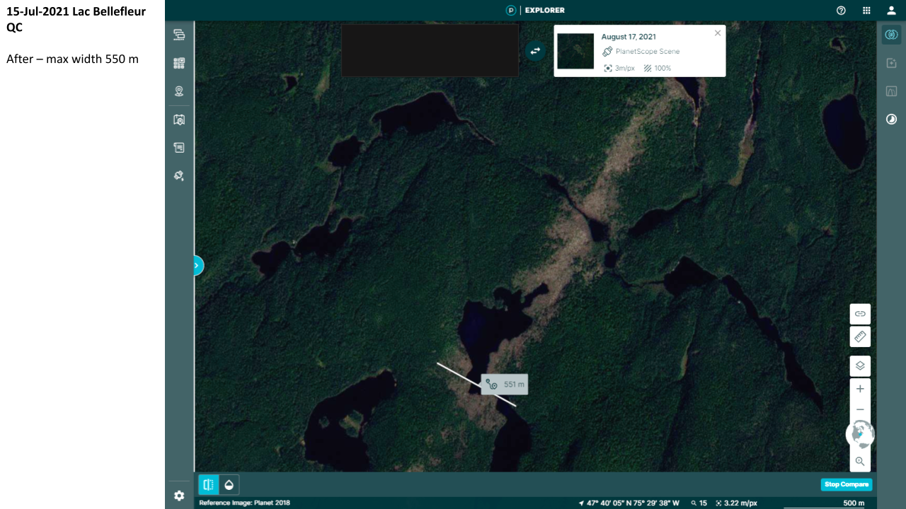
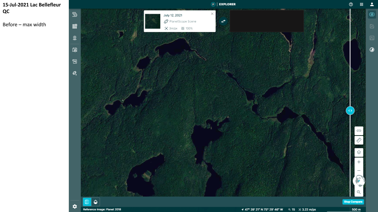
Event Name: Lac Bellefleur (Vallée-de-la-Gatineau), QC
Date: July 15, 2021
Start Time: 8:50 PM EDT (0050 UTC)
Final Classification: Tornado (Over Land)
Final EF-Scale Rating: EF2
EF-Scale Damage Indicator / Degree of Damage: C-T/DOD-6
Start of damage track: 47.6308N, 75.5564W
End of damage of track: 47.6917N, 75.4808W
Location of worst damage: 47.6625N, 75.5111W
Description: Satellite imagery review revealed a tornado damage path in forested areas in the Vallée-de-la-Gatineau Regional County Municipality north of Sainte-Anne-du-Lac. Tornado damage assessed as EF2, with an estimated max. wind speed of 190 km/h, track length of 8.90 km and max. path width of 550 m. Tornado motion was from the SW (approx. 220 degrees). Start time is radar estimated.
Event Name: Lac Mandjoci, QC
Date: August 29, 2021
Start Time: 8:42 PM EDT (0042 UTC)
Final Classification: Tornado (Over Land)
Final EF-Scale Rating: EF2
EF-Scale Damage Indicator / Degree of Damage: C-T/DOD-6
Start of damage track: 49.3450N, 77.9917W
End of damage of track: 49.3736N, 77.9497W
Location of worst damage: 49.3617N, 77.9667W
Description: Satellite imagery review revealed a tornado damage path in forested areas southeast of Joutel. Tornado damage assessed as EF2, with an estimated max. wind speed of 190 km/h, track length of 4.38 km and max. path width of 240 m. Tornado motion was from the SW (approx. 225 degrees). Start time is radar estimated.
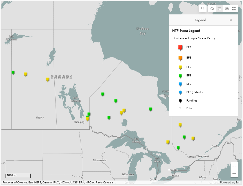
NTP Dashboard map showing the locations of the 17 new tornadoes for 2021.
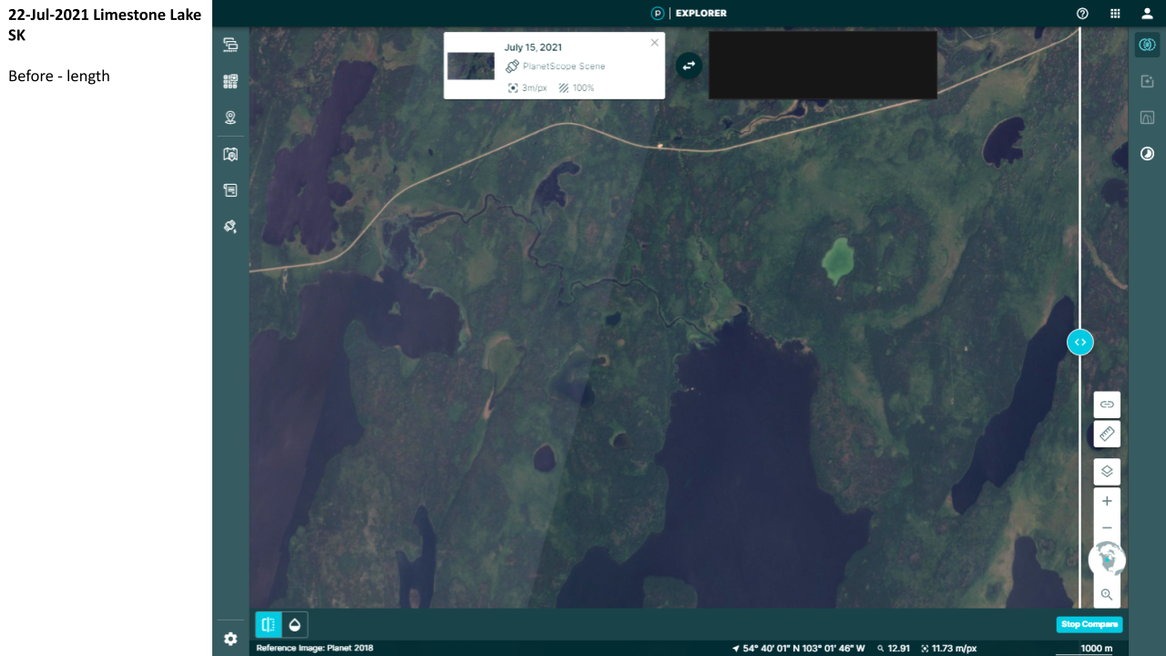
'Before' satellite image for the Limestone Lake, SK EF2 tornado on 22 Jul 2021.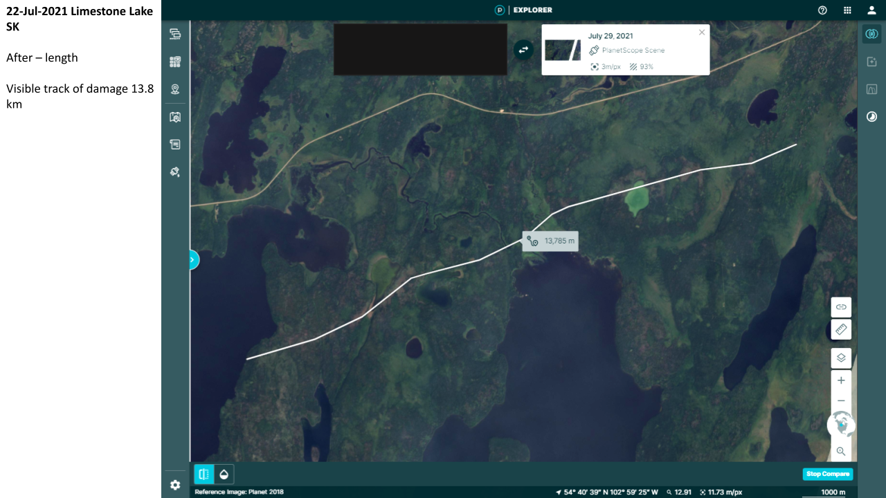
'After' satellite image for the Limestone Lake, SK EF2 tornado on 22 Jul 2021, with path length measurement superimposed.
'Before' satellite image for Lac Bellefleur (Vallée-de-la-Gatineau), QC EF2 tornado on 15 Jul 2021.
'After' satellite image for Lac Bellefleur (Vallée-de-la-Gatineau), QC EF2 tornado on 15 Jul 2021, with maximum path width measurement superimposed.