New tornadoes in NW ON on July 9
NTP investigation has resulted in 3 new tornadoes, and an upgrade to a previously confirmed tornado, in NW Ontario on July 9. Supercells on that day produced 1 EF2 tornado and 3 EF1 tornadoes. The lengthy delay in the assessment of these tornadoes is due to the frequent cloudiness over this part of NW ON over the past month, preventing analysis of high-resolution satellite imagery. This is the first recorded EF2 tornado in Canada in 2023, and the second EF2+ tornado.
Details are provided in the event summaries below, along with a map and satellite images. Event information can also be viewed and plotted via the NTP Dashboard at https://uwo.ca/ntp/dashboard.
====
Event Name: Landings Lake, ON
Date: July 9, 2023
Start Time: 2:40 PM CDT (1940 UTC)
Final Classification: Tornado (Over Land)
Final EF-Scale Rating: EF1
EF-Scale Damage Indicator / Degree of Damage: C-T/DOD-5
Start of damage track: 50.6347N, 92.3550W
End of damage track: 50.6325N, 92.3297W
Location of worst damage: 50.6347N, 92.3408W
Description: Satellite imagery review of a storm track of interest revealed a tornado damage path through forested areas near Landings Lake (north of Lac Seul). Damage assessed as EF1 tornado, with an estimated max. wind speed of 145 km/h, track length of 1.83 km and max. path width of 160 m. Tornado motion was from the W (approx. 275 degrees). Start time is radar estimated.
Event Name: Rude Lake, ON
Date: July 9, 2023
Start Time: 4:45 PM CDT (2145 UTC)
Final Classification: Tornado (Over Land)
Final EF-Scale Rating: EF1
EF-Scale Damage Indicator / Degree of Damage: C-T/DOD-5
Start of damage track: 49.8701N, 90.3438W
End of damage track: 49.8625N, 90.2814W
Location of worst damage: 49.8639N, 90.2903W
Description: Satellite imagery review of a storm track of interest revealed a tornado damage path through forested areas at Rude Lake (southeast of Savant Lake). Damage assessed as EF1 tornado, with an estimated max. wind speed of 145 km/h, track length of 4.15 km and max. path width of 210 m. Tornado motion was from the W (approx. 280 degrees). Start time is radar estimated.
Event Name: Pakashkan Lake, ON
Date: July 9, 2023
Start Time: 6:55 PM EDT (2255 UTC)
Final Classification: Tornado (Over Land)
Final EF-Scale Rating: EF1
EF-Scale Damage Indicator / Degree of Damage: C-T/DOD-5
Start of damage track: 49.3644N, 90.3506W
End of damage track: 49.3533N, 90.2581W
Location of worst damage: 49.3597N, 90.3061W
Description: Satellite imagery review of a storm track of interest revealed a tornado damage path through forested areas at Pakashkan Lake (north of Upsala). Damage assessed as EF1 tornado, with an estimated max. wind speed of 145 km/h, track length of 6.79 km and max. path width of 270 m. Tornado motion was from the W (approx. 280 degrees). Start time is radar estimated.
Event Name: Hine Lake, ON
Date: July 9, 2023
Start Time: 7:25 PM EDT (2325 UTC)
Final Classification: Tornado (Over Land)
Final EF-Scale Rating: EF2
EF-Scale Damage Indicator / Degree of Damage: C-T/DOD-6
Start of damage track: 49.3029N, 89.9530W
End of damage track: 49.2764N, 89.6934W
Location of worst damage: 49.2942N, 89.7658W
Description: Satellite imagery review of a storm track of interest revealed a tornado damage path through forested areas near Hine Lake (northeast of Upsala). Damage assessed as EF2 tornado, with an estimated max. wind speed of 190 km/h, track length of 19.6 km and max. path width of 770 m. Tornado motion was from the W (approx. 280 degrees). Start time is radar estimated.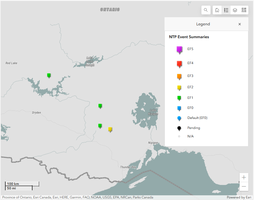
Map showing the location of the upgraded EF2 tornado and the three EF1 tornadoes in NW Ontario.
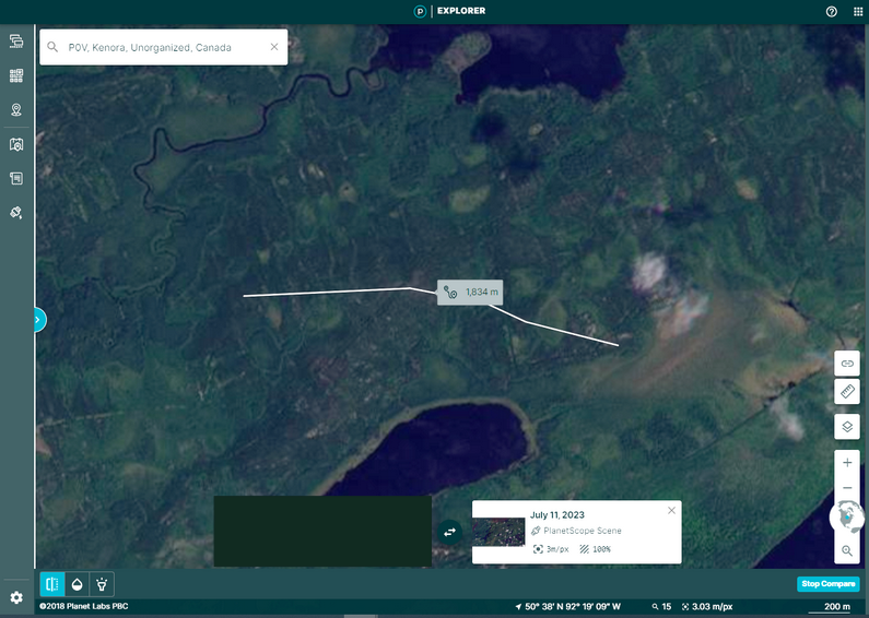
Planet Labs satellite image showing the track of the Landings Lake EF1 tornado.
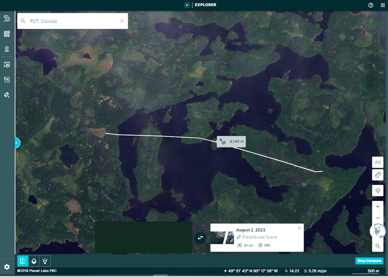
Planet Labs satellite image showing the track of the Rude Lake EF1 tornado.
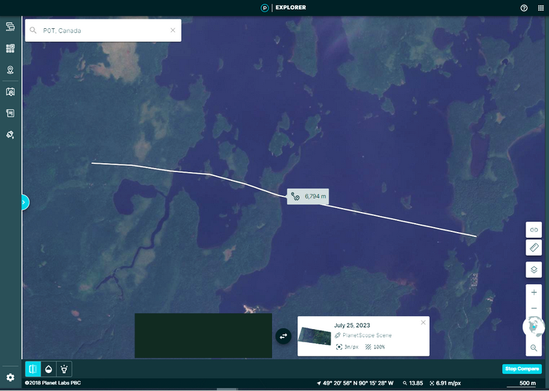
Planet Labs satellite image showing the track of the Pakashkan EF1 tornado.
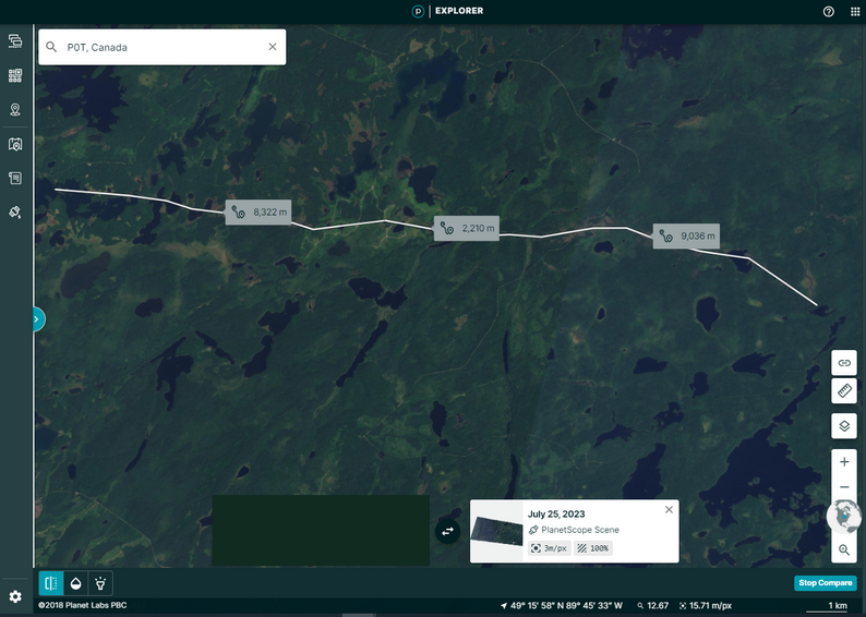
Planet Labs satellite image showing the track of the Hines Lake EF2 tornado. Note that no damage was detected in the middle section but there were few trees in that area and NTP allows a break in the track of up to 3 km before it is considered a new tornado.
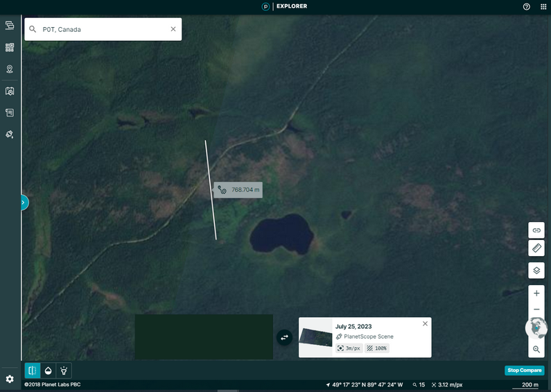
Planet Labs satellite image showing a zoom of the widest part of the EF2 tornado track. The tree damage can be easily seen in the image (patches of brown).