Didsbury AB Tornado an EF4
A powerful tornado hit a rural area south of Didsbury, Alberta on July 1st with numerous witnesses documenting the event through photos, video and personal accounts.
The Northern Tornadoes Project, in collaboration with the ECCC Prairie and Arctic Storm Prediction Centre, conducted a thorough ground and drone survey, with one NTP team documenting damage the evening of the event and two NTP teams working together the next day.
The survey teams found that there was enough evidence to rate the tornado damage at EF4, with a maximum wind speed of 275 km/h. The preliminary path length is 15.3 km and maximum path width 620 m.
Twelve residences were hit by the tornado: 3 were destroyed, 4 were left uninhabitable, and a further 5 were damaged.
One of the houses that was destroyed was found to be well built after an on-site engineering analysis. Using the EF scale tool, the damage indicator (DI) was 'One- or Two-Family Residences (FR12)', and the degree of damage (DOD) was 9 - meaning all walls collapsed. Given the house was well built, we could use the 'expected' maximum wind speed for DOD9 of 275 km/h. The wind speed range of EF4 is 270-310 km/h. So, the EF rating is low-end EF4. Details of the EF scale can be found here.
In terms of nearby corroborating damage, various farm equipment was flipped and thrown at that property. This includes a combine weighing almost 10,000 kg that was thrown at least 50 m, and then rolled for another 50-100 m after that. Wind tunnel studies of another combine that was hit by a previous Canadian tornado suggest a wind speed of 230 km/h for just flipping a combine. Tree stubbing / debarking and ground scouring are also consistent with a high-end tornado.
Thankfully, due in part to timely weather alerts, there was only one minor injury (a cut to a first responder, apparently).
Climatologically, the Didsbury EF4 tornado enters some rarefied territory among Canadian tornado events.
- It is the strongest recorded tornado in Alberta since the Edmonton F4 tornado of 1987 and one of only three tornadoes rated F/EF4 in Alberta (the other hit the Grassy Lake area in 1915).
- It is only the second tornado in Canada to have damage rated at EF4 on the Enhanced Fujita scale that was implemented in this country in 2013, with the other being the Alonsa, MB EF4 that also had a maximum wind speed of 275 km/h.
- Across the country, there have been only 21 'violent' tornadoes rated at F/EF4 or higher. One of these was Canada's only tornado rated at F5 - the Elie, MB tornado of 2007. Most of the others (12) have been in southern Ontario. Saskatchewan and Manitoba have also experienced F4-rated tornadoes (3 in SK, all 1920 and earlier; 2 in MB from 1977 and 1994).
- Though this was a climatologically significant tornado, it thankfully won't enter the list of Canada's top ten 'worst' tornadoes due to the single minor injury and limited property damage.
Below is the event summary that will go to NTP's open data and be accessible via the NTP dashboard. Several maps and images are also incluced.
A more complete report is planned.
====
Event Name: Didsbury, AB
Date: July 1, 2023
Start Time: 1:45 PM MDT (1945 UTC)
Final Classification: Tornado (over land)
Final EF-Scale Rating: EF4
EF-Scale Damage Indicator / Degree of Damage: FR12/DOD-9
Start of damage track: 51.6114N, 114.1989W
End of damage track: 51.5840N, 113.9973W
Location of Worst Damage: 51.6081N, 114.0966W
Description: Witnesses captured video of a tornado that developed southwest of Didsbury and tracked eastward to north of Carstairs. The tornado caused significant damage to multiple properties, destroying several houses and farm buildings. Notable tree damage occurred, and power poles and vehicles were also damaged. One minor injury was reported, and several dozen farm animals were killed. NTP ground and drone survey teams investigated along the damage track on July 1-3, 2023. Damage assessed as EF4 tornado, with an estimated max. wind speed of 275 km/h, track length of 15.3 km and max. path width of 620 m. Tornado motion was from the W (approx. 280 degrees). Satellite imagery review revealed damage to crops and some trees in the path.
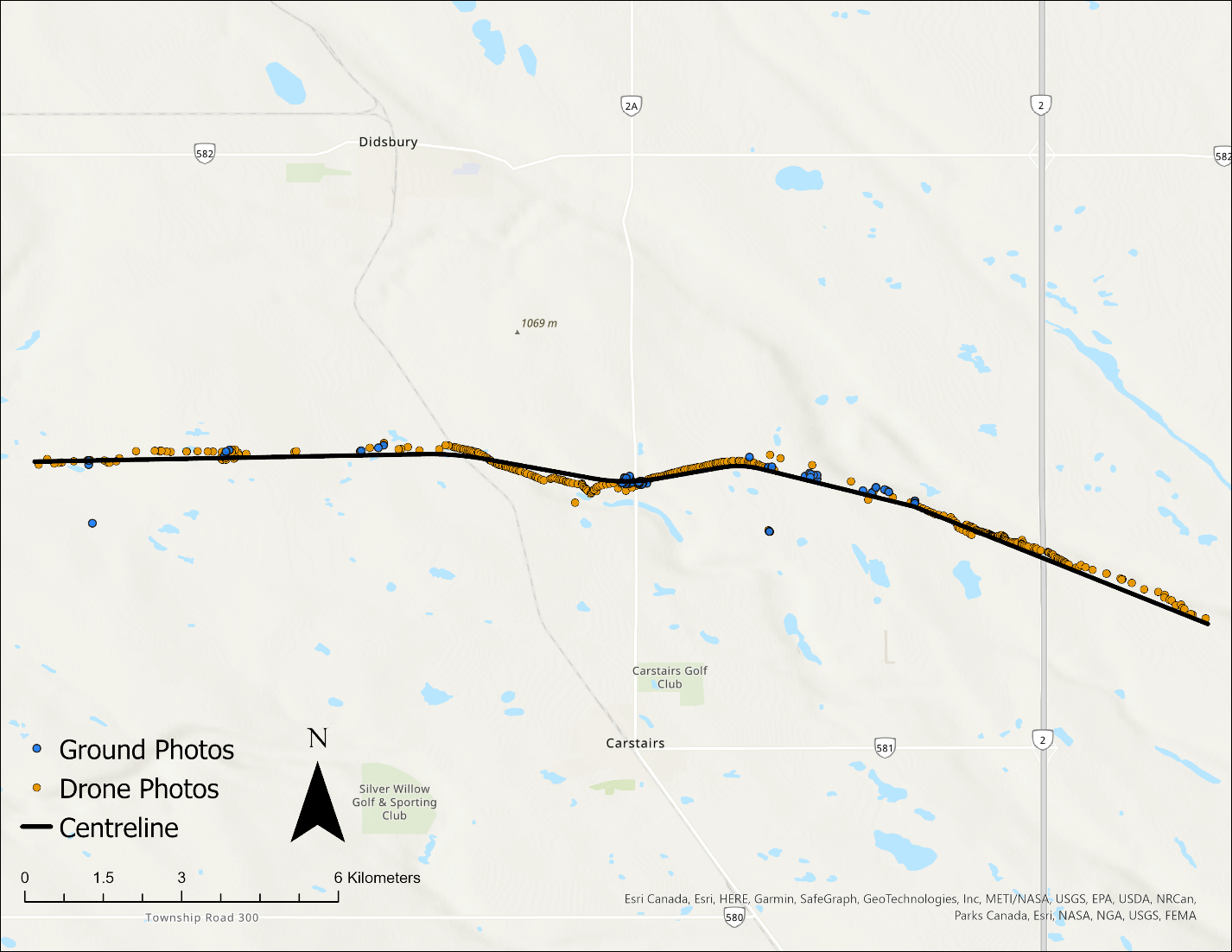
Preliminary map of the Didsbury tornado path with length 15.3 km.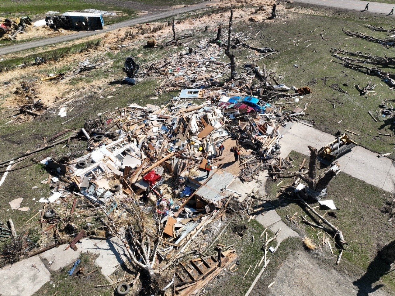
The EF4-rated damage occurred at the farm on the west side of Highway 2A. It was a well-constructed home, and all exterior and above-grade interior walls were knocked down. Debris was scattered well downwind. One person took shelter in the basement and survived.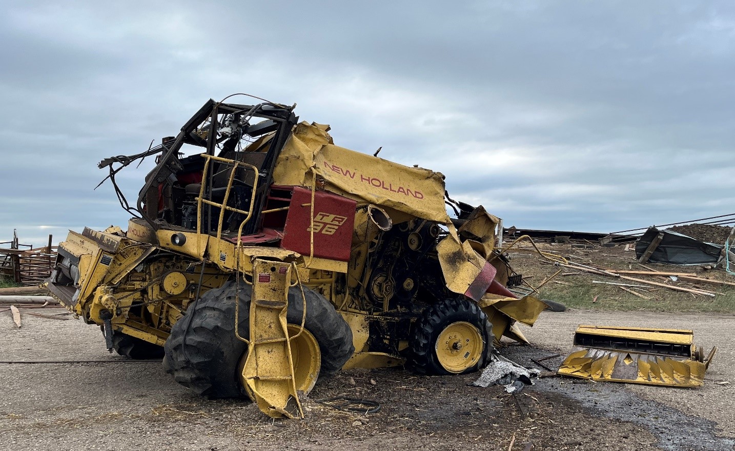
Combine weighing nearly 10,000 kg was tossed ~50 m and rolled at least another 50 m.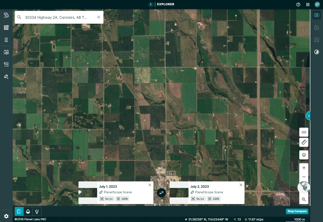
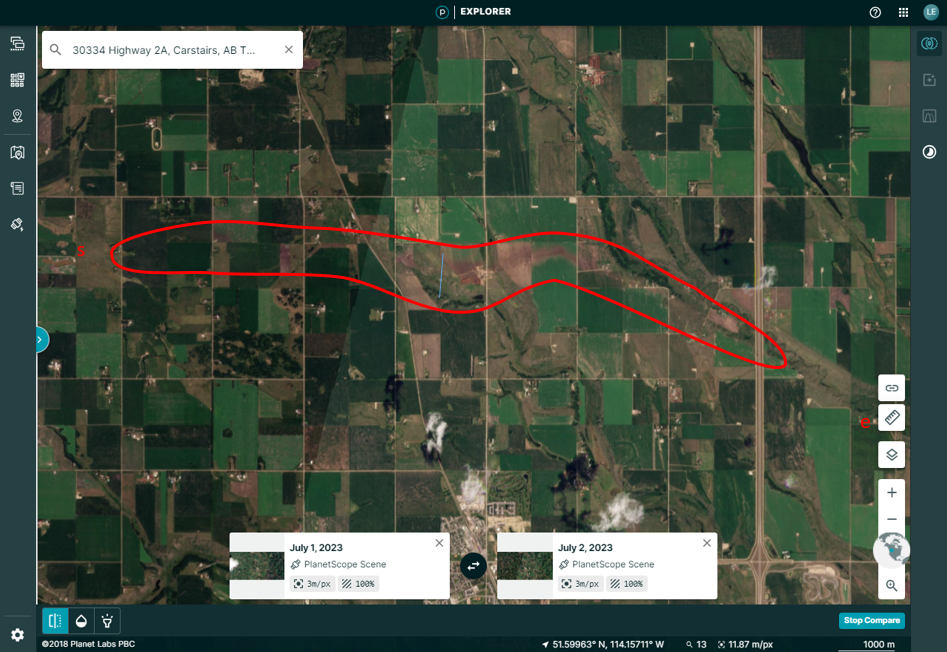
Before (top) and after (bottom) high-resolution satellite images from Planet.com. Ground scouring through crops makes the tornado's path easy to see in spots. The red line indicates the the path visible from satellite imagery. The 's' and the 'e' mark the start and end points of the path found by the ground/drone survey team. It is typical for satellite imagery to have somewhat shorter visible paths.