Ontario Tornado Update #1 - May 30
A number damaging wind events in Ontario required additional data collection and analysis. Those investigations have now been completed and the final tornado numbers for both Ontario and Canada can now be tallied for 2022.
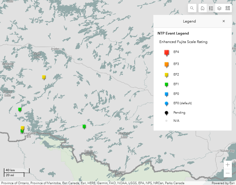
Update #1 - May 30
A quasi-linear convective system in NW ON on this day resulted in a number of areas of damage. One tornado track (Boffin Lake) had been confirmed previously but is now updated based on additional data. Four new tornadoes (1 EF2, 3 EF1) have also been confirmed based on additional data collected and subsequent analysis. The details are provided in the summaries below.
====
Event Name: Crozier, ON
Date: May 30, 2022
Start Time: 7:45 PM CDT (0045 UTC)
Final Classification: Tornado (Over Land)
Final EF-Scale Rating: EF1
EF-Scale Damage Indicator / Degree of Damage: C-T/DOD-5
Start of damage track: 48.6148N, 93.5304W
End of damage of track: 48.6393N, 93.5187W
Location of worst damage: 48.6263N, 93.5253W
Description: Weak tree damage was reported west of Fort Frances near Crozier after a storm passed through. No injuries were reported. Satellite imagery review revealed weak damage in the area, though the cause was unclear and event could not be classified based on satellite imagery and a damage report. Aerial imagery was collected during an aircraft survey on September 30, 2022, and review of that imagery confirmed tornado damage in the area. Damage assessed as EF1, with an estimated max. wind speed of 145 km/h, track length of 2.90 km and max. path width of 190 m. Tornado motion was from the S (approx. 200 degrees). Start time is radar estimated.
Event Name: Boffin Lake, ON
Date: May 30, 2022
Start Time: 7:50 PM CDT (0050 UTC)
Final Classification: Tornado (Over Land)
Final EF-Scale Rating: EF2
EF-Scale Damage Indicator / Degree of Damage: C-T/DOD-6
Start of damage track: 48.6699N, 93.5219W
End of damage of track: 48.8154N, 93.4426W
Location of worst damage:48.7368N, 93.4928W
Description: Satellite imagery review revealed a tornado damage path and concurrent downburst damage in forested areas northwest of Fort Frances. Aerial imagery was collected during an aircraft survey on September 30, 2022. Tornado damage assessed as EF2, with an estimated max. wind speed of 190 km/h, track length of 17.6 km and max. path width of 820 m. Tornado motion was from the S (approx. 200 degrees). Start time is radar estimated. Concurrent downburst damage preliminarily assessed as EF1.
Event Name: Black Narrows (Rainy River), ON
Date: May 30, 2022
Start Time: 8:00 PM CDT (0100 UTC)
Final Classification: Tornado (Over Land)
Final EF-Scale Rating: EF1
EF-Scale Damage Indicator / Degree of Damage: C-T/DOD-5
Start of damage track: 48.9114N, 93.5778W
End of damage of track: 48.9411N, 93.5711W
Location of worst damage: 48.9233N, 93.5708W
Description: Satellite imagery review of a storm track of interest revealed a tornado damage path through forested areas north of Northwest Bay. Damage assessed as EF1, with an estimated max. wind speed of 145 km/h, track length of 3.50 km and max. path width of 330 m. Tornado motion was from the SSW (approx. 195 degrees). Start time is radar estimated.
Event Name: Kaoskauta Lake, ON
Date: May 30, 2022
Start Time: 8:48 PM CDT (0148 UTC)
Final Classification: Tornado (Over Land)
Final EF-Scale Rating: EF2
EF-Scale Damage Indicator / Degree of Damage: C-T/DOD-6
Start of damage track: 49.3689N, 93.0754W
End of damage of track: 49.3988N, 93.0866W
Location of worst damage: 49.3826N, 93.0837W
Description: Satellite imagery review of a storm track of interest revealed a swath of damage at Kaoskauta Lake, southwest of Dryden. The cause of the damage was unclear and event could not be classified based on satellite imagery alone. Aerial imagery was collected during an aircraft survey on October 30, 2022, and review of that imagery confirmed tornado damage along with weak downburst in the area. Tornado damage assessed as EF2, with an estimated max. wind speed of 190 km/h, track length of 3.50 km and max. path width of 330 m. Tornado motion was from the SSE (approx. 165 degrees). Start time is radar estimated. Concurrent downburst damage preliminarily assessed as EF1.
Event Name: Harnett Lake, ON
Date: May 30, 2022
Start Time: 9:00 PM CDT (0200 UTC)
Final Classification: Tornado (Over Land)
Final EF-Scale Rating: EF1
EF-Scale Damage Indicator / Degree of Damage: C-T/DOD-5
Start of damage track: 48.6757N, 92.2308W
End of damage of track: 48.7021N, 92.2361W
Location of worst damage: 48.6827N, 92.2343W
Description: Satellite imagery review of a storm track of interest revealed a swath of damage at Harnett Lake, southeast of Seine River Village. The cause of the damage was unclear and event could not be classified based on satellite imagery alone. Aerial imagery was collected during an aircraft survey on September 30, 2022, and review of that imagery confirmed tornado damage in the area. Damage assessed as EF1, with an estimated max. wind speed of 170 km/h, track length of 3.07 km and max. path width of 300 m. Tornado motion was from the S (approx. 170 degrees). Start time is radar estimated.