NTP confirms three new tornadoes - in ON, AB and SK
NTP has confirmed three new tornadoes - in NW ON on May 30, in southern AB on June 6, and in southern SK on June 10. Thanks to Environment Canada and Instant Weather for collaboration on getting the evidence together for these. The event summaries for the three tornadoes are provided below with an associated image for each.
Event Name: Boffin Lake, ON
Date: May 30, 2022
Time: 7:50 PM CDT (0050Z)
Final Classification: Tornado (Over Land)
Final EF-Scale Rating: EF2
EF-Scale Damage Indicator / Degree of Damage: C-T/DOD-6
Start of damage track: 48.7122N, 93.5003W
End of damage of track: 48.7533N, 93.4854W
Location of worst damage: 48.7367N, 93.4911W
Description: Satellite imagery review of a storm track of interest revealed a tornado damage path through forested areas. Damage assessed as EF2, with an estimated max. wind speed of 190 km/h, track length of 4.73 km and max. path width of 720 m. Tornado motion was from the SSW (approx. 195 degrees).
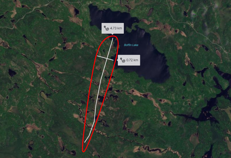
High-resolution Planet satellite imagery showing a long, narrow path of tree damage to the SW of Boffin Lake (within red outline). The track and max width are shown as white lines.
Event Name: Enchant, AB
Date: June 6, 2022
Time: 4:10 PM MDT (2210Z)
Final Classification: Tornado (Over Land)
Final EF-Scale Rating: EF1
EF-Scale Damage Indicator / Degree of Damage: C-SFLF/DOD-3
Start of damage track: 50.1659N, 112.5768W
End of damage of track: 50.1558N, 112.5643W
Location of worst damage: 50.1633N, 112.5688W
Description: Witnesses captured video and photos of multiple funnel clouds developing in the Travers - Enchant area. Damage to grain bins, a shed and a quonset hut was reported at a property west of Enchant in the vicinity of a funnel cloud seen by a local resident. No injuries were reported. An NTP ground and drone survey was completed on June 10, 2022. Damage assessed as EF1 tornado, with an estimated max. wind speed of 150 km/h, track length of 1.0 km and max. path width of 120 m. Tornado motion was from the NNW (approx. 330 degrees). Further investigation pending, including satellite imagery review.
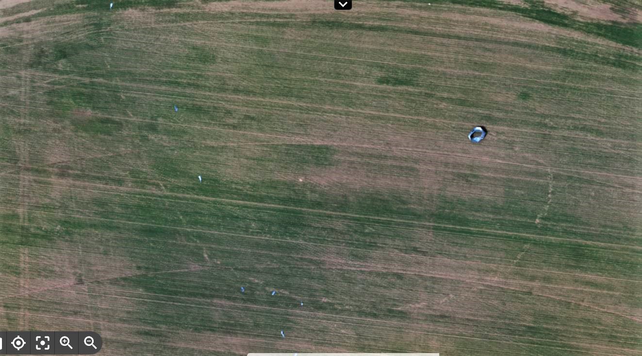
Drone image showing a large fragment of the destroyed grain bin that scoured the ground as it was moved in a loop around the tornado.
Event Name: Maymont, SK
Date: June 10, 2022
Time: 4:21 PM CST (2221Z)
Final Classification: Tornado (Over Land)
Preliminary EF-Scale Rating: EF0-Default
Event Location: 52.543N, 107.583W
Description: Witness captured a video of a tornado over an open field east of Maymont. No injuries were reported. No damage has been reported at this time and the preliminary EF-Scale assessment is EF0-Default. Further investigation pending, including satellite imagery review.
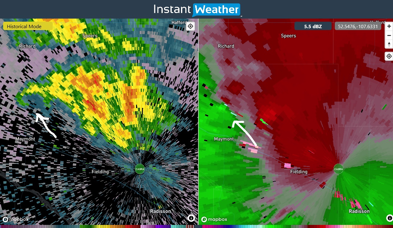
Radar image showing the location of a hook echo and a low-level radial velocity couplet just north of Maymont at 4:12 PM CST, just prior to the video being taken. The supercell radar echoes are not as well defined as usual because the storm is so close to the radar.