New QC/NB tornadoes from July 20/21
While all of the straightforward tornado events for the 2022 season have already been assessed and documented, there remains a number of more challenging events that have required extra analysis work (and in some cases extra observations e.g. aircraft flights).
Storms in ON and QC on July 20th caused wind damage across a fairly large area. One tornado in ON and four tornadoes in QC have already been confirmed (see https://uwo.ca/ntp/blog/2022/july_20th_tornadoes_in_ontario_and_quebec.html). Other areas of damage were more complicated and required an aircraft aerial survey to classify and assess. This resulted in two additional tornadoes being confirmed.
Storms in QC and NB on July 21st also caused complex areas of damage that required extra effort with the analysis. Four EF1 tornadoes have been confirmed in QC and one EF2 tornado has been confirmed in NB based on this work.
Summaries for these tornadoes appear below.
===
Event Name: Lac Antiquois, QC
Date: July 20, 2022
Start Time: 8:30 PM EDT (0030 UTC)
Final Classification: Tornado (Over Land)
Final EF-Scale Rating: EF1
EF-Scale Damage Indicator / Degree of Damage: C-T/DOD-5
Start of damage track: 47.1091N, 77.8559W
End of damage of track: 47.1179N, 77.8494W
Location of worst damage: 47.1128N, 77.8529W
Description: Satellite imagery review of a storm track of interest revealed a swath of damage in the Lac Ombon area of the Abitibi-Témiscamingue region. The cause of the damage was unclear and event type could not be assessed based on satellite imagery alone. Aerial imagery was collected during an aircraft survey on September 3, 2022, and review of that imagery confirmed weak downburst damage in the Lac Ombon area and a track of tornado damage along Lac Antiquois. Tornado damage assessed as EF1, with an estimated max. wind speed of 145 km/h, track length of 1.13 km and max. path width of 210 m. Tornado motion was from the SSW (approx. 205 degrees). Start time is radar estimated.
Event Name: Lac Tona (Vallée-de-l'Or), QC
Date: July 20, 2022
Start Time: 9:50 PM EDT (0150 UTC)
Final Classification: Tornado (Over Land)
Final EF-Scale Rating: EF2
EF-Scale Damage Indicator / Degree of Damage: C-T/DOD-6
Start of damage track: 47.4042N, 77.3844W
End of damage of track: 47.4235N, 77.3602W
Location of worst damage: 47.4122N, 77.3766W
Description: Satellite imagery review of a storm track of interest revealed a tornado damage path at Lac Pedro (Pontiac region) and additional visible damage to the NE near Lac Tona (Vallée-de-l'Or region). It was initially unclear if the two areas of damage were connected and aerial imagery was collected during an aircraft survey on September 3, 2022 to further examine visible treefall. Review of this imagery confirmed two separate tornado damage paths from the same parent storm. Damage at Lac Tona was assessed as an EF2 tornado, with an estimated max. wind speed of 190 km/h, track length of 2.87 km and max. path width of 210 m. Tornado motion was from the SW (approx. 220 degrees). Start time is radar estimated. The Lac Pedro tornado was also assessed as EF2 (previous blog post).
Event Name: Saint-André-du-Lac-Saint-Jean, QC
Date: July 21, 2022
Start Time: 1:00 PM EDT (1700 UTC)
Final Classification: Tornado (Over Land)
Final EF-Scale Rating: EF1
EF-Scale Damage Indicator / Degree of Damage: C-T/DOD-5
Start of damage track: 48.3275N, 71.9578W
End of damage of track: 48.3653N, 71.8994W
Location of worst damage: 48.3353N, 71.9400W
Description: Tree damage was reported northeast of Saint-André-du-Lac-Saint-Jean following a storm passing through the area. No injuries were reported. Satellite imagery review revealed a tornado damage path and damage was assessed as EF1 tornado, with an estimated max. wind speed of 145 km/h, track length of 6.20 km and max. path width of 420 m. Tornado motion was from the SW (approx. 225 degrees). Start time is radar estimated.
Event Name: Lac Maher (La Côte-de-Beaupré), QC
Date: July 21, 2022
Start Time: 2:15 PM EDT (1815 UTC)
Final Classification: Tornado (Over Land)
Final EF-Scale Rating: EF1
EF-Scale Damage Indicator / Degree of Damage: C-T/DOD-5
Start of damage track: 47.8342N, 71.5494W
End of damage of track: 47.8728N, 71.4939W
Location of worst damage: 47.8614N, 71.5108W
Description: Satellite imagery review of a storm track of interest revealed a tornado damage path through forested areas near Lac Maher in the regional county municipality of La Côte-de-Beaupré. Damage assessed as EF1 tornado, with an estimated max. wind speed of 145 km/h, track length of 6.11 km and max. path width of 210 m. Tornado motion was from the SW (approx. 225 degrees). Start time is radar estimated.
Event Name: Lac-Saint-Joseph, QC
Date: July 21, 2022
Start Time: 2:25 PM EDT (1825 UTC)
Final Classification: Tornado (Over Land)
Final EF-Scale Rating: EF1
EF-Scale Damage Indicator / Degree of Damage: C-T/DOD-5
Start of damage track: 46.9136N, 71.7100W
End of damage of track: 46.9708N, 71.5683W
Location of worst damage: 46.9561N, 71.6011W
Description: Satellite imagery review of a storm track of interest revealed a tornado damage path in the Lac-Saint-Joseph area. Damage assessed as EF1 tornado, with an estimated max. wind speed of 145 km/h, track length of 12.9 km and max. path width of 350 m. Tornado motion was from the WSW (approx. 240 degrees). Start time is radar estimated.
Event Name: Lac des Ventres Rouges (Tewkesbury), QC
Date: July 21, 2022
Start Time: 2:55 PM EDT (1855 UTV)
Final Classification: Tornado (Over Land)
Final EF-Scale Rating: EF1
EF-Scale Damage Indicator / Degree of Damage: C-T/DOD-5
Start of damage track: 47.0258N, 71.4528W
End of damage of track: 47.0525N, 71.3917W
Location of worst damage: 47.0417N, 71.4194W
Description: Tree damage was reported at Lac des Ventres Rouges south of Tewkesbury following a storm passing through the area. No injuries were reported. Satellite imagery review revealed a tornado damage path and damage was assessed as EF1 tornado, with an estimated max. wind speed of 145 km/h, track length of 5.61 km and max. path width of 230 m. Tornado motion was from the SW (approx. 235 degrees). Start time is radar estimated.
Event Name: Wild Goose Lake, NB
Date: July 21, 2022
Start Time: 6:45 PM ADT (2145 UTC)
Final Classification: Tornado (Over Land)
Final EF-Scale Rating: EF2
EF-Scale Damage Indicator / Degree of Damage: C-T/DOD-6
Start of damage track: 47.8586N, 68.3353W
End of damage of track: 47.8794N, 68.3131W
Location of worst damage: 47.8772N, 68.3169W
Description: Satellite imagery review of a storm track of interest revealed a tornado damage path through forested areas near Wild Goose Lake, north of Summit Depot. Damage assessed as EF2 tornado, with an estimated max. wind speed of 190 km/h, track length of 3.03 km and max. path width of 290 m. Tornado motion was from the SW (approx. 215 degrees). Start time is radar estimated.
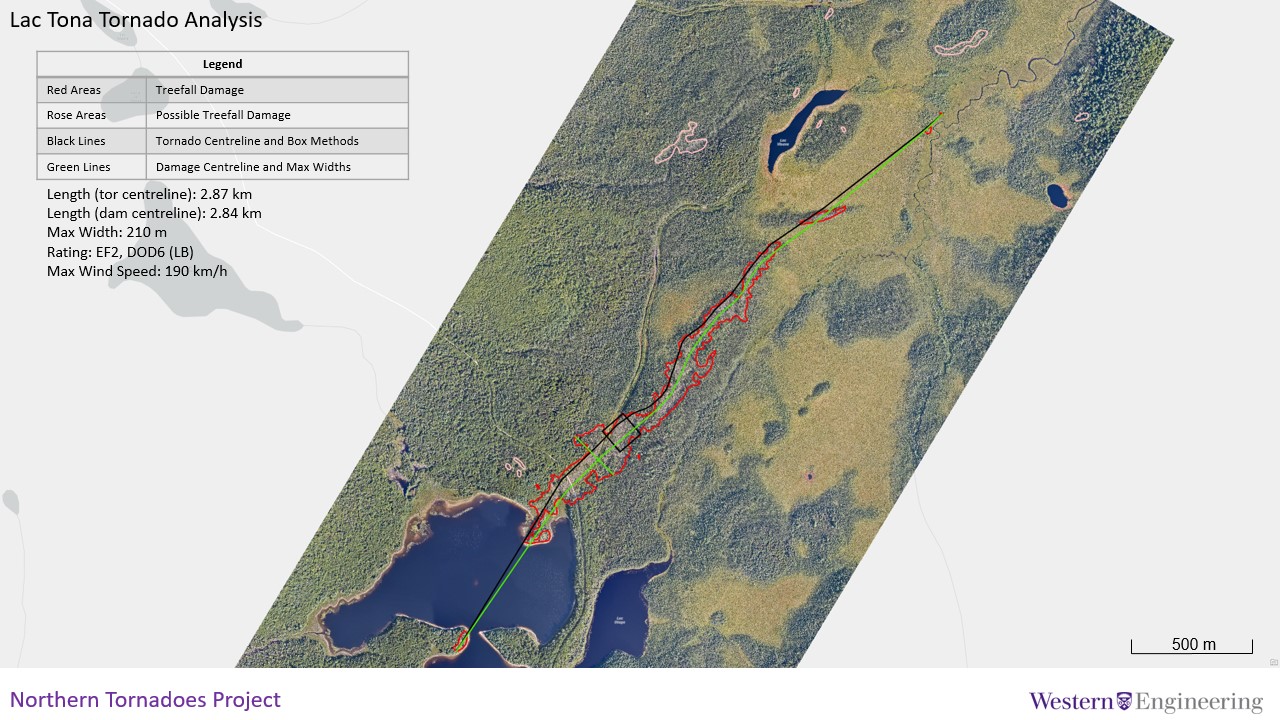
NTP analysis of aircraft aerial imagery from the Lac Tona, QC area showing the estimated track of the EF2 tornado.
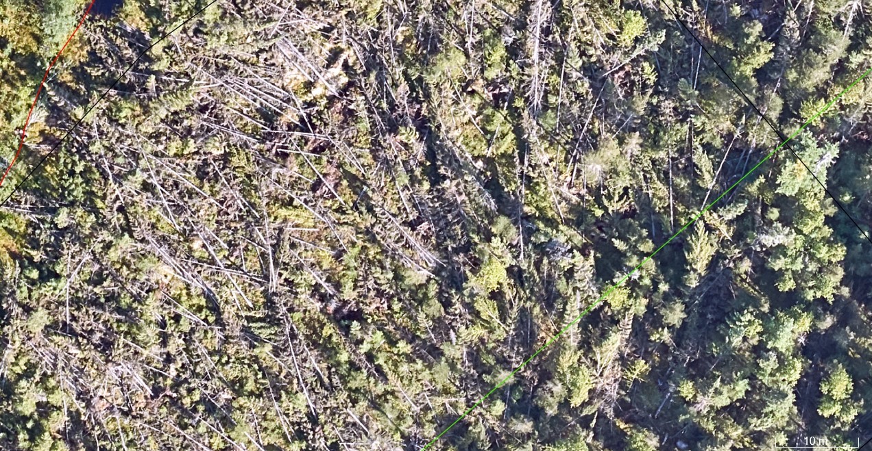
Full-resolution imagery of tree damage from the Lac Tona, QC EF2 tornado.
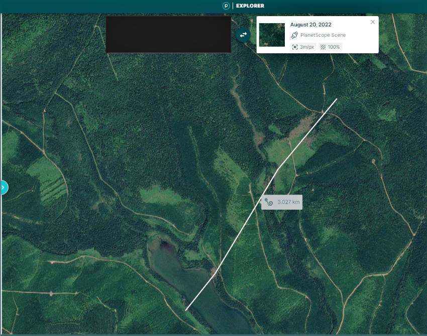
Planet satellite image showing the tree damage associated with the Wild Goose Lake, NB EF2 tornado (estimated track superimposed). The worst tree damage with nearly 100% treefall occurred near the end of the track.