New QC tornadoes: June 16th
Careful and thorough NTP investigation has led to the confirmation of six new tornadoes in Quebec from supercell thunderstorms on June 16th. These storms occurred more than 250 km north of Montreal and moved toward the NE toward Lac Saint-Jean. Two of the tornadoes were assigned an EF2 rating while the rest were assigned EF1, based on analysis of high-resolution satellite imagery. Note that there were also two weak tornadoes on this day in Ontario.
Below are the events summaries in chronological order, followed by some event imagery.
====
Event Name: Lac aux Eaux Mortes (Le Domaine-du-Roy), QC
Date: June 16, 2022
Start Time: 2:20 PM EDT (1820 UTC)
Final Classification: Tornado (Over Land)
Final EF-Scale Rating: EF1
EF-Scale Damage Indicator / Degree of Damage: C-T/DOD-5
Start of damage track:48.5031N, 72.7914W
End of damage of track: 48.5389N, 72.6647W
Location of worst damage: 48.5342N, 72.6858W
Description: Satellite imagery review of a storm track of interest revealed tornado and downburst damage in forested areas southwest of Saint-Felicien (Le Domaine-du-Roy). Tornado damage assessed as EF1, with an estimated max. wind speed of 145 km/h, track length of 10.3 km and max. path width of 520 m. Tornado motion was from the WSW (approx. 245 degrees). Start time is radar estimated. Damage caused by a downburst at the end of the tornado damage path near Lac des Lachance was assessed as EF1, with an estimated max. wind speed of 145 km/h.
Event Name: Lac Johnson (La Tuque), QC
Date: June 16, 2022
Start Time: 6:10 PM EDT (2210 UTC)
Final Classification: Tornado (Over Land)
Final EF-Scale Rating: EF2
EF-Scale Damage Indicator / Degree of Damage: C-T/DOD-6
Start of damage track: 47.7619N, 74.9456W
End of damage of track: 47.7942N, 74.8631W
Location of worst damage: 47.7736N, 74.9161W
Description: Satellite imagery review of a storm track of interest revealed a tornado damage path through forested areas near Lac Johnson, southwest of Parent (La Tuque). Damage assessed as EF2 tornado, with an estimated max. wind speed of 190 km/h, track length of 7.16 km and max. path width of 470 m. Tornado motion was from the WSW (approx. 240 degrees). Start time is radar estimated.
Event Name: Lac Betty (La Tuque), QC
Date: June 16, 2022
Start Time: 6:30 PM EDT (2230 UTC)
Final Classification: Tornado (Over Land)
Final EF-Scale Rating: EF2
EF-Scale Damage Indicator / Degree of Damage: C-T/DOD-6
Start of damage track: 48.0331N, 74.3319W
End of damage of track: 48.0425N, 74.2944W
Location of worst damage: 48.0392N, 74.3103W
Description: Satellite imagery review of a storm track of interest revealed a tornado damage path through forested areas north of McCarthy (La Tuque). Damage assessed as EF2 tornado, with an estimated max. wind speed of 190 km/h, track length of 3.63 km and max. path width of 310 m. Tornado motion was from the WSW (approx. 250 degrees). Start time is radar estimated.
Event Name: McCarthy, QC
Date: June 16, 2022
Start Time: 7:15 PM EDT (2315 UTC)
Final Classification: Tornado (Over Land)
Final EF-Scale Rating: EF1
EF-Scale Damage Indicator / Degree of Damage: C-T/DOD-5
Start of damage track: 47.8808N, 74.3331W
End of damage of track: 47.9131N, 74.2728W
Location of worst damage: 47.8972N, 74.2978W
Description: Satellite imagery review of a storm track of interest revealed a tornado damage path through forested areas near McCarthy (La Tuque). Damage assessed as EF1 tornado, with an estimated max. wind speed of 145 km/h, track length of 5.81 km and max. path width of 370 m. Tornado motion was from the SW (approx. 230 degrees). Start time is radar estimated.
Event Name: Casey, QC
Date: June 16, 2022
Start Time: 7:35 PM EDT (2335 UTC)
Final Classification: Tornado (Over Land)
Final EF-Scale Rating: EF1
EF-Scale Damage Indicator / Degree of Damage: C-T/DOD-5
Start of damage track: 47.9047N, 74.1319W
End of damage of track: 47.9339N, 74.0303W
Location of worst damage: 47.9286N, 74.0500W
Description: Satellite imagery review of a storm track of interest revealed a tornado damage path through forested areas near Casey (La Tuque). Damage assessed as EF1 tornado, with an estimated max. wind speed of 145 km/h, track length of 8.39 km and max. path width of 400 m. Tornado motion was from the WSW (approx. 245 degrees). Start time is radar estimated.
Event Name: Lac Usik (La Tuque), QC
Date: June 16, 2022
Start Time: 8:00 PM EDT (0000 UTC)
Final Classification: Tornado (Over Land)
Final EF-Scale Rating: EF1
EF-Scale Damage Indicator / Degree of Damage: C-T/DOD-5
Start of damage track: 48.1145N, 73.4951W
End of damage of track: 48.1186N, 73.4311W
Location of worst damage: 48.1156N, 73.4847W
Description: Satellite imagery review of a storm track of interest revealed a tornado damage path through forested areas northeast of Wemotaci (La Tuque). Damage assessed as EF1 tornado, with an estimated max. wind speed of 145 km/h, track length of 4.79 km and max. path width of 360 m. Tornado motion was from the W (approx. 265 degrees). Start time is radar estimated.
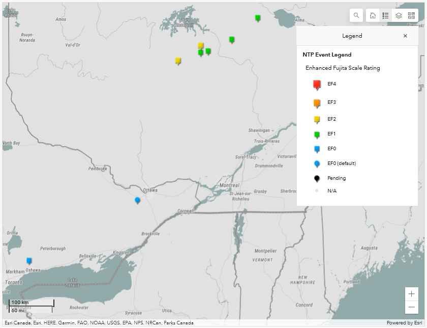
NTP dashboard map showing the locations and ratings of the 6 QC tornadoes and the 2 ON tornadoes on June 16th.
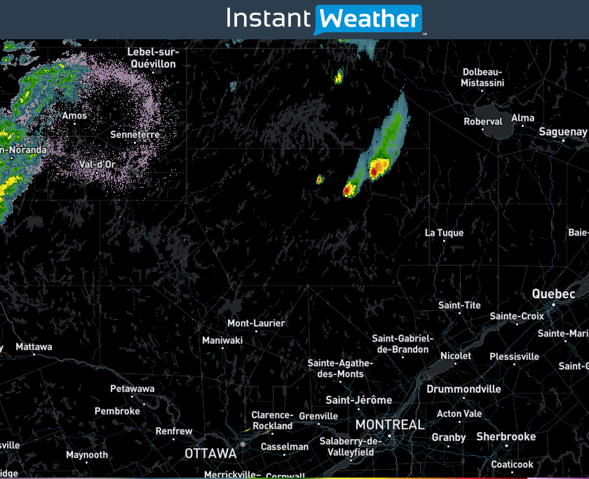
Supercells captured by the long-range low-level scan from the CASLA radar at 1930 EDT on June 16th.
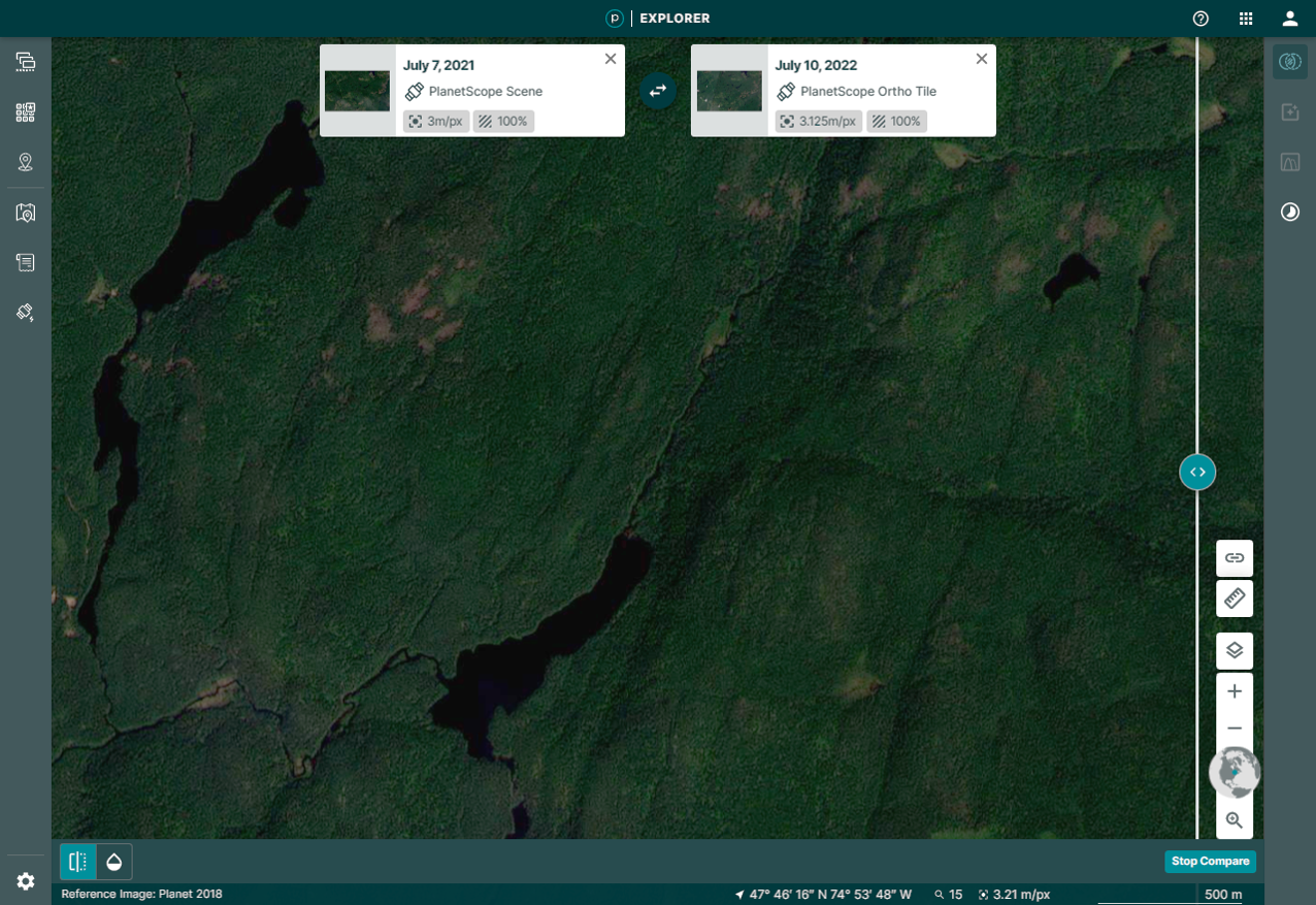
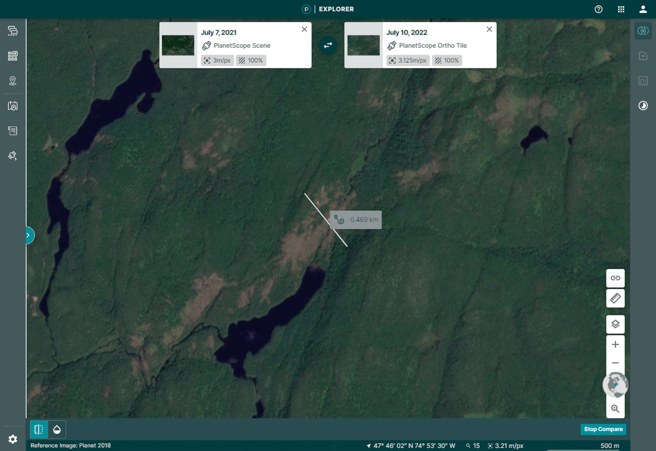
Satellite images before and after the Lac Johnson EF2 tornado, including the max width measurement.