New QC tornadoes: July 20th
Careful and thorough NTP investigation has led to the confirmation of four additional tornadoes in Quebec from QLCS thunderstorms on July 20th. These storms occurred south of the Val-d'Or area of Quebec and moved toward the NE. One of the new tornadoes was assigned an EF2 rating while the rest were assigned EF1, based on analysis of high-resolution satellite imagery. Note that this is part of a larger outbreak that day - there were six other tornadoes in QC and one other tornado in Ontario that had already been confirmed.
Below are the events summaries in chronological order, followed by some event imagery.
====
Event Name: Lac Stone Island (Témiscamingue), QC
Date: July 20, 2022
Start Time: 8:05 PM EDT (0005 UTC)
Final Classification: Tornado (Over Land)
Final EF-Scale Rating: EF1
EF-Scale Damage Indicator / Degree of Damage: C-T/DOD-5
Start of damage track: 46.4264N, 78.5383W
End of damage of track: 46.4617N, 78.4564W
Location of worst damage: 46.4531N, 78.4753W
Description: Satellite imagery review of a storm track of interest revealed tornado damage in forested areas of the Témiscamingue regional county municipality (northeast of Mattawa, ON). Damage assessed as EF1 tornado, with an estimated max. wind speed of 145 km/h, track length of 7.77 km and max. path width of 320 m. Tornado motion was from the WSW (approx. 240 degrees). Start time is radar estimated.
Event Name: Baie Vallot (Vallée-de-l'Or), QC
Date: July 20, 2022
Start Time: 10:30 PM EDT (0230 UTC)
Final Classification: Tornado (Over Land)
Final EF-Scale Rating: EF2
EF-Scale Damage Indicator / Degree of Damage: C-T/DOD-6
Start of damage track: 47.4647N, 76.8792W
End of damage of track: 47.4778N, 76.8714W
Location of worst damage: 47.4736N, 76.8744W
Description: Satellite imagery review of a storm track of interest revealed tornado damage in forested areas along Baie Vallot of Réservoir Dozois (Vallée-de-l'Or). Damage assessed as EF2 tornado, with an estimated max. wind speed of 190 km/h, track length of 1.58 km and max. path width of 370 m. Tornado motion was from the SSW (approx. 200 degrees). Start time is radar estimated.
Event Name: Lac Langford (Vallée-de-l'Or), QC
Date: July 20, 2022
Start Time: 10:55 PM EDT (0255 UTC)
Final Classification: Tornado (Over Land)
Final EF-Scale Rating: EF1
EF-Scale Damage Indicator / Degree of Damage: C-T/DOD-5
Start of damage track: 47.8192N, 76.8448W
End of damage of track: 47.9108N, 76.7728W
Location of worst damage: 47.8639N, 76.8131W
Description: Satellite imagery review of a storm track of interest revealed tornado damage in forested areas northeast of Dorval-Lodge (Vallée-de-l'Or). Damage assessed as EF1 tornado, with an estimated max. wind speed of 145 km/h, track length of 11.6 km and max. path width of 460 m. Tornado motion was from the SSW (approx. 210 degrees). Start time is radar estimated.
Event Name: Lac Cade (Pontiac), QC
Date: July 20, 2022
Start Time: 11:50 PM EDT (0350 UTC)
Final Classification: Tornado (Over Land)
Final EF-Scale Rating: EF1
EF-Scale Damage Indicator / Degree of Damage: C-T/DOD-5
Start of damage track: 47.1006N, 77.2803W
End of damage of track: 47.1211N, 77.2564W
Location of worst damage: 47.1136N, 77.2650W
Description: Satellite imagery review of a storm track of interest revealed tornado damage in forested areas of the Pontiac regional county municipality (southwest of Dorval-Lodge). Damage assessed as EF1 tornado, with an estimated max. wind speed of 145 km/h, track length of 2.91 km and max. path width of 290 m. Tornado motion was from the SW (approx. 220 degrees). Start time is radar estimated.
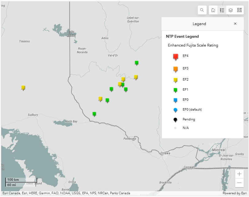
NTP dashboard map showing the locations of all 11 tornadoes on July 20th, including the 4 new tornadoes.
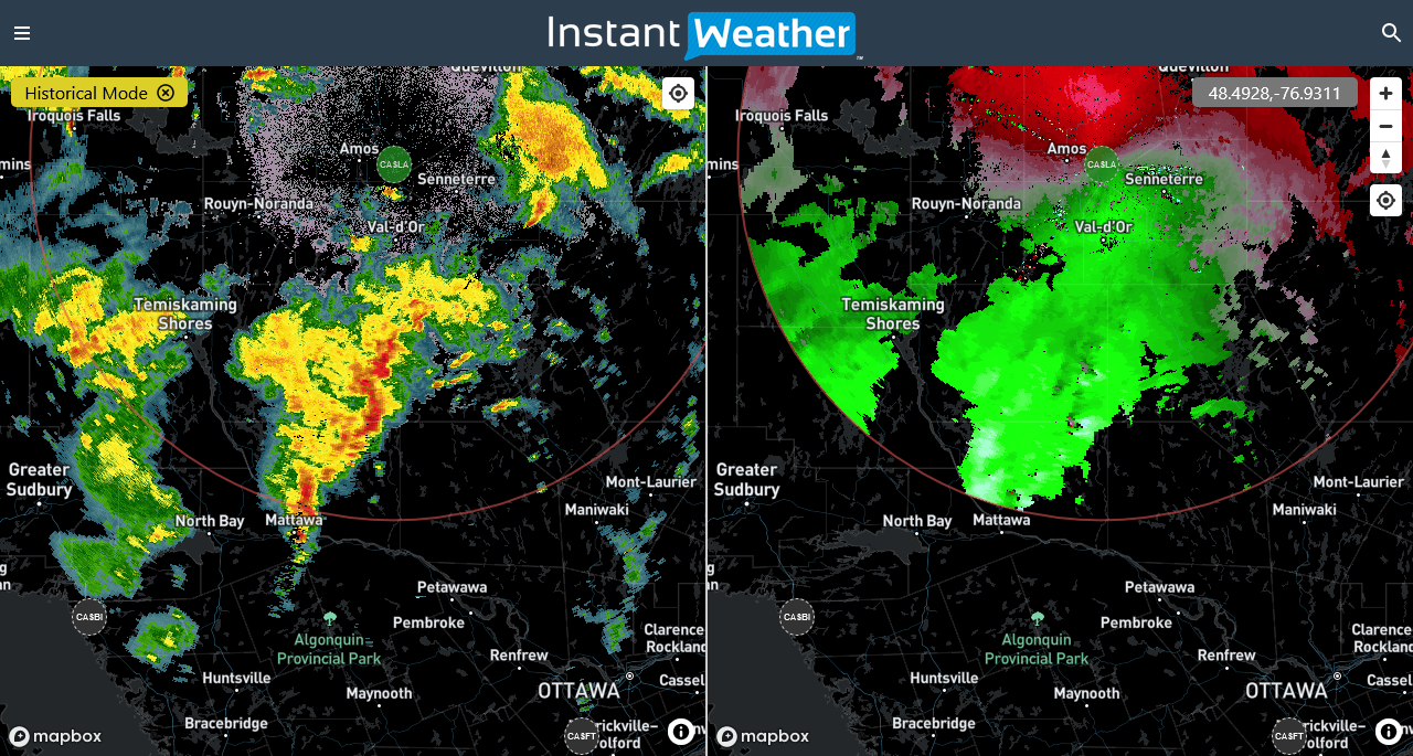
CASLA radar imagery showing the reflectivity (left) and radial velocity (right) for the QLCS storms from July 20th at 2006 EDT.
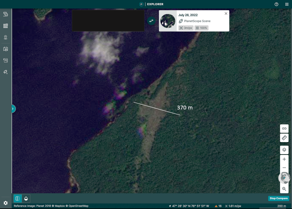
Satellite image showing the tree damage associated with the Baie Vallot EF2 tornado, with the max width superimposed.