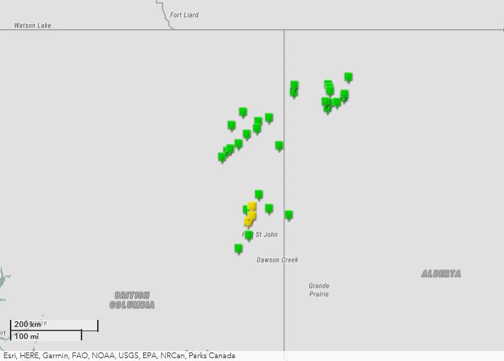
New Downbursts in BC and AB
On June 30th, 2021, storms started up around 7 PM MST (local time) in NE BC. The storms continued for 7+ hrs, tracking northeastward into Alberta, then weakening after 3:00 AM MDT (local time) on July 1st, 2021.
The first downburst event was at 7:50 PM MST near Fontas, BC and the last event was at 3:00 AM MDT in Meander River, AB (span of 6h 10m).
Damage was reported in the Fort St. John BC area (events already on Open Data, from Moberly Lake north to Altona). Otherwise damage occurred in largely unpopulated wilderness.
* Total area reviewed using satellite imagery: 124,162 km2* Total reviewed using high-res aerial imagery: 237 km2
* Total number of downburst events identified: 31 (19 in BC, 12 in AB)
BC Summary details for new events:
Event Name: Fontas (1), BC
Date: June 30, 2021
Time: 7:50 PM MST (0250Z)
Final Classification: Downburst
Final EF-Scale Rating: EF1
EF-Scale Damage Indicator / Degree of Damage: C-T/DOD-5
Event location: 58.1587N, 121.8274W
Description: Satellite imagery review of a storm track revealed visible tree damage near Fontas. Two downburst events were identified along the track, the first of which was SSW of Fontas. Damage assessed as EF1 downburst, with an estimated max. wind speed of 145 km/h.
Event Name: Fontas (2), BC
Date: June 30, 2021
Time: 8:15 PM MST (0315Z)
Final Classification: Downburst
Final EF-Scale Rating: EF1
EF-Scale Damage Indicator / Degree of Damage: C-T/DOD-5
Event location: 58.3902N, 121.4349W
Description: Satellite imagery review of a storm track revealed visible tree damage near Fontas. Two downburst events were identified along the track, the second of which was NE of Fontas. Damage assessed as EF1 downburst, with an estimated max. wind speed of 145 km/h.
Event Name: Monais Lake, BC
Date: June 30, 2021
Time: 9:30 PM MST (0430Z)
Final Classification: Downburst
Final EF-Scale Rating: EF1
EF-Scale Damage Indicator / Degree of Damage: C-T/DOD-5
Event location: 56.0859N, 121.2377W
Description: Satellite imagery review of a storm track revealed visible tree damage near Monais Lake. Damage assessed as EF1 downburst, with an estimated max. wind speed of 170 km/h. An earlier downburst event from the same developing QLCS was identified to the south near Moberly Lake and the storm later produced several more damaging downburst events as it continued north of Fort St. John.
Event Name: Sikanni Chief, BC
Date: June 30, 2021
Time: 9:25 PM MST (0425Z)
Final Classification: Downburst
Final EF-Scale Rating: EF1
EF-Scale Damage Indicator / Degree of Damage: C-T/DOD-5
Event location: 57.5672N, 122.1579W
Description: Satellite imagery review of a storm track revealed widespread visible tree damage from the Sikanni Chief area extending northeastward to Kahntah. Eight downburst events were identified along the storm track, the first of which was NE of Sikanni Chief. Damage assessed as EF1 downburst, with an estimated max. wind speed of 145 km/h.
Event Name: Tommy Lakes (1), BC
Date: June 30, 2021
Time: 9:40 PM MST (0440Z)
Final Classification: Downburst
Final EF-Scale Rating: EF1
EF-Scale Damage Indicator / Degree of Damage: C-T/DOD-5
Event location: 57.6692N, 121.9885W
Description: Satellite imagery review of a storm track revealed widespread visible tree damage from the Sikanni Chief area extending northeastward to Kahntah. Eight downburst events were identified along the storm track, the second of which was SSW of Tommy Lakes. Damage assessed as EF1 downburst, with an estimated max. wind speed of 170 km/h.
Event Name: Tommy Lakes (2), BC
Date: June 30, 2021
Time: 9:50 PM MST (0450Z)
Final Classification: Downburst
Final EF-Scale Rating: EF1
EF-Scale Damage Indicator / Degree of Damage: C-T/DOD-5
Event location: 57.7221N, 121.8693W
Description: Satellite imagery review of a storm track revealed widespread visible tree damage from the Sikanni Chief area extending northeastward to Kahntah. Eight downburst events were identified along the storm track, the third of which was S of Tommy Lakes. Damage assessed as EF1 downburst, with an estimated max. wind speed of 145 km/h.
Event Name: Tommy Lakes (3), BC
Date: June 30, 2021
Time: 10:10 PM MST (0510Z)
Final Classification: Downburst
Final EF-Scale Rating: EF1
EF-Scale Damage Indicator / Degree of Damage: C-T/DOD-5
Event location: 57.8144N, 121.5936W
Description: Satellite imagery review of a storm track revealed widespread visible tree damage from the Sikanni Chief area extending northeastward to Kahntah. Eight downburst events were identified along the storm track, the fourth of which was E of Tommy Lakes. Damage assessed as EF1 downburst, with an estimated max. wind speed of 145 km/h.
Event Name: Kahntah (1), BC
Date: June 30, 2021
Time: 10:30 PM MST (0530Z)
Final Classification: Downburst
Final EF-Scale Rating: EF1
EF-Scale Damage Indicator / Degree of Damage: C-T/DOD-5
Event location: 57.9958N, 121.3011W
Description: Satellite imagery review of a storm track revealed widespread visible tree damage from the Sikanni Chief area extending northeastward to Kahntah. Eight downburst events were identified along the storm track, the fifth of which was SW of Kahntah. Damage assessed as EF1 downburst, with an estimated max. wind speed of 145 km/h.
Event Name: Kahntah (2), BC
Date: June 30, 2021
Time: 10:50 PM MST (0550Z)
Final Classification: Downburst
Final EF-Scale Rating: EF1
EF-Scale Damage Indicator / Degree of Damage: C-T/DOD-5
Event location: 58.0903N, 120.9388W
Description: Satellite imagery review of a storm track revealed widespread visible tree damage from the Sikanni Chief area extending northeastward to Kahntah. Eight downburst events were identified along the storm track, the sixth of which was SSW of Kahntah. Damage assessed as EF1 downburst, with an estimated max. wind speed of 145 km/h.
Event Name: Kahntah (3), BC
Date: June 30, 2021
Time: 11:00 PM MST (0600Z)
Final Classification: Downburst
Final EF-Scale Rating: EF1
EF-Scale Damage Indicator / Degree of Damage: C-T/DOD-5
Event location: 58.2228N, 120.8971W
Description: Satellite imagery review of a storm track revealed widespread visible tree damage from the Sikanni Chief area extending northeastward to Kahntah. Eight downburst events were identified along the storm track, the seventh of which was S of Kahntah. Damage assessed as EF1 downburst, with an estimated max. wind speed of 145 km/h.
Event Name: Kahntah (4), BC
Date: June 30, 2021
Time: 11:15 PM MST (0615Z)
Final Classification: Downburst
Final EF-Scale Rating: EF1
EF-Scale Damage Indicator / Degree of Damage: C-T/DOD-5
Event location: 58.2868N, 120.5299W
Description: Satellite imagery review of a storm track revealed widespread visible tree damage from the Sikanni Chief area extending northeastward to Kahntah. Eight downburst events were identified along the storm track, the last of which was SE of Kahntah. Damage assessed as EF1 downburst, with an estimated max. wind speed of 170 km/h.
Event Name: Doig River, BC
Date: June 30, 2021
Time: 11:25 PM MST (0625Z)
Final Classification: Downburst
Final EF-Scale Rating: EF1
EF-Scale Damage Indicator / Degree of Damage: C-T/DOD-5
Event location: 56.6050N, 120.5380W
Description: Satellite imagery review of a storm track revealed visible tree damage near Doig River. Damage assessed as EF1 downburst, with an estimated max. wind speed of 145 km/h.
Event Name: Etthithun Lake, BC
Date: June 30, 2021
Time: 11:45 PM MST (0645Z)
Final Classification: Downburst
Final EF-Scale Rating: EF1
EF-Scale Damage Indicator / Degree of Damage: C-T/DOD-5
Event location: 57.7795N, 120.1791W
Description: Satellite imagery review of a storm track revealed visible tree damage south of Etthithun Lake. Damage assessed as EF1 downburst, with an estimated max. wind speed of 145 km/h.
-----
AB summary details for new events:
Event Name: Zama Lake (1), AB
Date: July 1, 2021
Time: 1:25 AM MDT (0725Z)
Final Classification: Downburst
Final EF-Scale Rating: EF1
EF-Scale Damage Indicator / Degree of Damage: C-T/DOD-5
Event location: 58.7486N, 119.6850W
Description: Satellite imagery review of a storm track revealed visible tree damage west of Zama Lake. Two downburst events were identified. Damage from the southern event was assessed as EF1 downburst, with an estimated max. wind speed of 145 km/h.
Event Name: Zama Lake (2), AB
Date: July 1, 2021
Time: 1:30 AM MDT (0730Z)
Final Classification: Downburst
Final EF-Scale Rating: EF1
EF-Scale Damage Indicator / Degree of Damage: C-T/DOD-5
Event location: 58.8793N, 119.6561W
Description: Satellite imagery review of a storm track revealed visible tree damage west of Zama Lake. Two downburst events were identified. Damage from the northern event was assessed as EF1 downburst, with an estimated max. wind speed of 145 km/h.
Event Name: Basset Lake, AB
Date: July 1, 2021
Time: 2:25 AM MDT (0825Z)
Final Classification: Downburst
Final EF-Scale Rating: EF1
EF-Scale Damage Indicator / Degree of Damage: C-T/DOD-5
Event location: 58.4707N, 118.5002W
Description: Satellite imagery review of a storm track revealed visible tree damage north of Basset Lake. Damage assessed as EF1 downburst, with an estimated max. wind speed of 145 km/h.
Event Name: Chateh (1), AB
Date: July 1, 2021
Time: 2:25 AM MDT (0825Z)
Final Classification: Downburst
Final EF-Scale Rating: EF1
EF-Scale Damage Indicator / Degree of Damage: C-T/DOD-5
Event location: 58.5758N, 118.5744W
Description: Satellite imagery review of a storm track revealed visible tree damage SE of Chateh. Three downburst events were identified. Damage from the first event of the three was assessed as EF1 downburst, with an estimated max. wind speed of 145 km/h.
Event Name: Chateh (2), AB
Date: July 1, 2021
Time: 2:30 AM MDT (0830Z)
Final Classification: Downburst
Final EF-Scale Rating: EF1
EF-Scale Damage Indicator / Degree of Damage: C-T/DOD-5
Event location: 58.5599N, 118.4199W
Description: Satellite imagery review of a storm track revealed visible tree damage SE of Chateh. Three downburst events were identified. Damage from the second event of the three was assessed as EF1 downburst, with an estimated max. wind speed of 145 km/h.
Event Name: Chateh (3), AB
Date: July 1, 2021
Time: 2:40 AM MDT (0840Z)
Final Classification: Downburst
Final EF-Scale Rating: EF1
EF-Scale Damage Indicator / Degree of Damage: C-T/DOD-5
Event location: 58.5665N, 118.1815W
Description: Satellite imagery review of a storm track revealed visible tree damage SE of Chateh. Three downburst events were identified. Damage from the final event of the three was assessed as EF1 downburst, with an estimated max. wind speed of 145 km/h.
Event Name: Habay (1), AB
Date: July 1, 2021
Time: 2:35 AM MDT (0835Z)
Final Classification: Downburst
Final EF-Scale Rating: EF1
EF-Scale Damage Indicator / Degree of Damage: C-T/DOD-5
Event location: 58.8827N, 118.4766W
Description: Satellite imagery review of a storm track revealed visible tree damage in the Habay area. Three downburst events were identified. Damage from the event NE of Habay was assessed as EF1 downburst, with an estimated max. wind speed of 145 km/h.
Event Name: Habay (2), AB
Date: July 1, 2021
Time: 2:35 AM MDT (0835Z)
Final Classification: Downburst
Final EF-Scale Rating: EF1
EF-Scale Damage Indicator / Degree of Damage: C-T/DOD-5
Event location: 58.8348N, 118.4428W
Description: Satellite imagery review of a storm track revealed visible tree damage in the Habay area. Three downburst events were identified. Damage from the event directly E of Habay was assessed as EF1 downburst, with an estimated max. wind speed of 145 km/h.
Event Name: Habay (3), AB
Date: July 1, 2021
Time: 2:35 AM MDT (0835Z)
Final Classification: Downburst
Final EF-Scale Rating: EF1
EF-Scale Damage Indicator / Degree of Damage: C-T/DOD-5
Event location: 58.7753N, 118.4142W
Description: Satellite imagery review of a storm track revealed visible tree damage in the Habay area. Three downburst events were identified. Damage from the event SE of Habay was assessed as EF1 downburst, with an estimated max. wind speed of 145 km/h.
Event Name: Hutch Lake (1), AB
Date: July 1, 2021
Time: 2:45 AM MDT (0845Z)
Final Classification: Downburst
Final EF-Scale Rating: EF1
EF-Scale Damage Indicator / Degree of Damage: C-T/DOD-5
Event location: 58.7163N, 117.9188W
Description: Satellite imagery review of a storm track revealed visible tree damage west of Hutch Lake. Two downburst events were identified. Damage from the northern event was assessed as EF1 downburst, with an estimated max. wind speed of 145 km/h.
Event Name: Hutch Lake (2), AB
Date: July 1, 2021
Time: 2:45 AM MDT (0845Z)
Final Classification: Downburst
Final EF-Scale Rating: EF1
EF-Scale Damage Indicator / Degree of Damage: C-T/DOD-5
Event location: 58.6617N, 117.9331W
Description: Satellite imagery review of a storm track revealed visible tree damage west of Hutch Lake. Two downburst events were identified. Damage from the southern event was assessed as EF1 downburst, with an estimated max. wind speed of 145 km/h.
Event Name: Meander River, AB
Date: July 1, 2021
Time: 3:00 AM MDT (0900Z)
Final Classification: Downburst
Final EF-Scale Rating: EF1
EF-Scale Damage Indicator / Degree of Damage: C-T/DOD-5
Event location: 59.0229N, 117.7919W
Description: Satellite imagery review of a storm track revealed visible tree damage in near Meander River. Damage assessed as EF1 downburst, with an estimated max. wind speed of 145 km/h.