May 21 derecho update #1 of 2: one more EF2 tornado
After exhaustive data collection and analysis, NTP is ready to release further updates on the May 21 derecho that affected southern Ontario and Quebec.
Update #1 - Tornadoes
1a. Refined Uxbridge tornado data
Based on recent damage reports and satellite analysis, we have revised the path of the Uxbridge tornado - extending its length from 16.0 km to 16.9 km. All other stats including the EF rating and the maximum width remain the same. Here is the updated event summary information.
Event Name: Uxbridge, ON
Date: May 21, 2022
Time: 1:15 PM EDT (1715Z)
Final Classification: Tornado (Over Land)
Final EF-Scale Rating: EF2
EF-Scale Damage Indicator / Degree of Damage: ACT/DOD-4
Start of damage track: 44.1058N, 79.1458W
End of damage of track: 44.1433N, 78.9403W
Location of worst damage: 44.1099N, 79.1245W
Description: Structural and tree damage reported in Uxbridge after a storm passed through the area. Two apartment buildings, several homes and business buildings suffered damage. Two vehicles were also flipped and/or rolled several feet. Numerous trees were snapped and uprooted. No major injuries requiring treatment were reported. An NTP ground and drone survey was completed on May 22, 2022 in Uxbridge and eastward to Lake Scugog. Satellite imagery review confirmed intermittent weak tree damage visible along the NTP survey route. Damage assessed as EF2 tornado, with an estimated max. wind speed of 195 km/h, track length of 16.9 km and max path width of 260 m. Motion was from the WSW (approx 255 degrees), with the tornado passing just south of the Greenbank-Uxbridge-Port Perry Airfield.
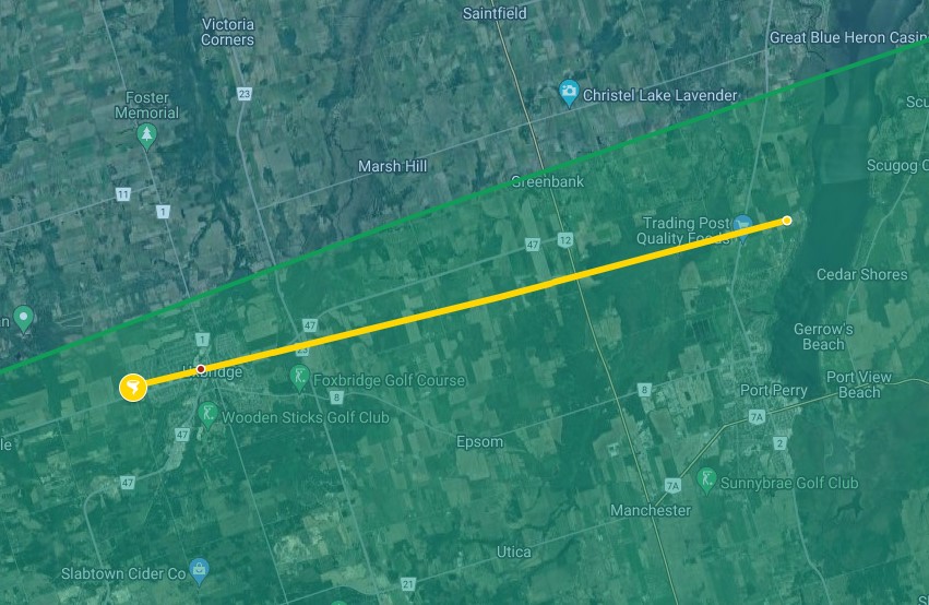
Map of extended Uxbridge tornado. Red dot indicates the area with the worst damage along the track.
1b. An additional EF2 tornado
There were a number of areas of enhanced damage along the derecho path, and each was investigated to determine if the damage was caused by a downburst or tornado.
In addition to the previously confirmed tornadoes at London (two EF1s) and Uxbridge (one EF2), we were also able to confirm a tornado that occurred east of Lake Scugog starting near St. Christopher and ending west of Lifford. We were provided with aerial photographs along this path that clearly showed the level of destruction to farm structures and trees. Satellite imagery also showed similar damage at a lower resolution, and confirmed that the enhanced damage was along a long, narrow path. Finally, KBUF Doppler radar shows a distinct rotation signature along the leading edge of the storm system near St. Christopher at 1:35 pm ET and near Franklin, northeast of Lifford, at 1:43 pm ET.
The worst of the damage was near the end of the track NW of Lifford. Here, a machine shed was destroyed giving an estimated max. wind speed of 180 km/h. As the tornado dissipated, a downburst developed just south of the track that caused up to EF2 damage as it grew in width to almost 2.5 km. Barns and a machine shed were destroyed, there were numerous of power poles down along a short stretch of Highway 35, and several areas had significant swaths of snapped and/or uprooted trees. The maximum wind speed in this area is estimated at 195 km/h and is therefore also assigned a rating of EF2. Here is the preliminary event summary information.
Event Name: St. Christopher, ON
Date: May 21, 2022
Time: 1:35 PM EDT (1735Z)
Final Classification: Tornado (Over Land)
Preliminary EF-Scale Rating: EF2
EF-Scale Damage Indicator / Degree of Damage: SBO/DOD-8
Start of damage track: 44.1755N, 78.7722W
End of damage of track: 44.1928N, 78.6694W
Location of worst damage: 44.1910N, 78.6777W
Description: Notable structural and tree damage was reported in the Township of Scugog and southern areas of the City of Kawartha Lakes after a storm passed through the area. Photos collected during a flight by private citizens on behalf of NTP documented damage to barns, outbuildings and homes at several rural properties in Janetville and Yelverton areas. Strong tree damage was also observed in the forested areas along the path, which was also visible during satellite imagery review. A co-located velocity couplet was seen by KBUF radar along the storm track from St. Christopher to north of Brunswick. Damage is assessed as EF2 tornado, with an estimated max. wind speed of 180 km/h, track length of 8.5 km and max. path width of 700 m. Tornado motion was from the WSW (approx. 255 degrees). A downburst affecting the Lifford area, to the ENE of the tornado track, developed as the St. Christopher tornado dissipated. The concurrent downburst damage was assessed at EF2, with an estimated max. wind speed of 195 km/h.
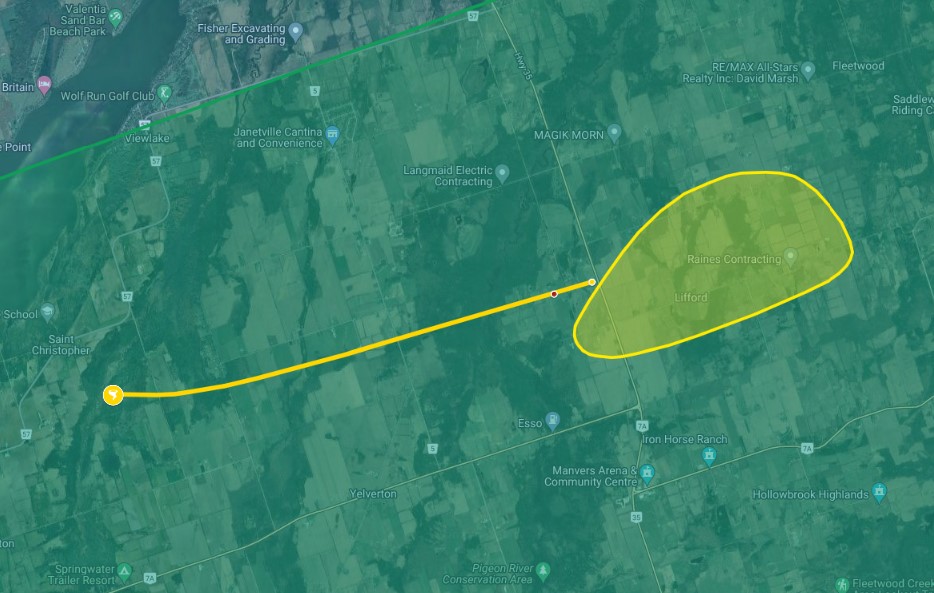
Map of new St. Christopher EF2 tornado and the EF2 downburst that developed as the tornado dissipated. The red dot indicates the area of worst damage along the tornado track.
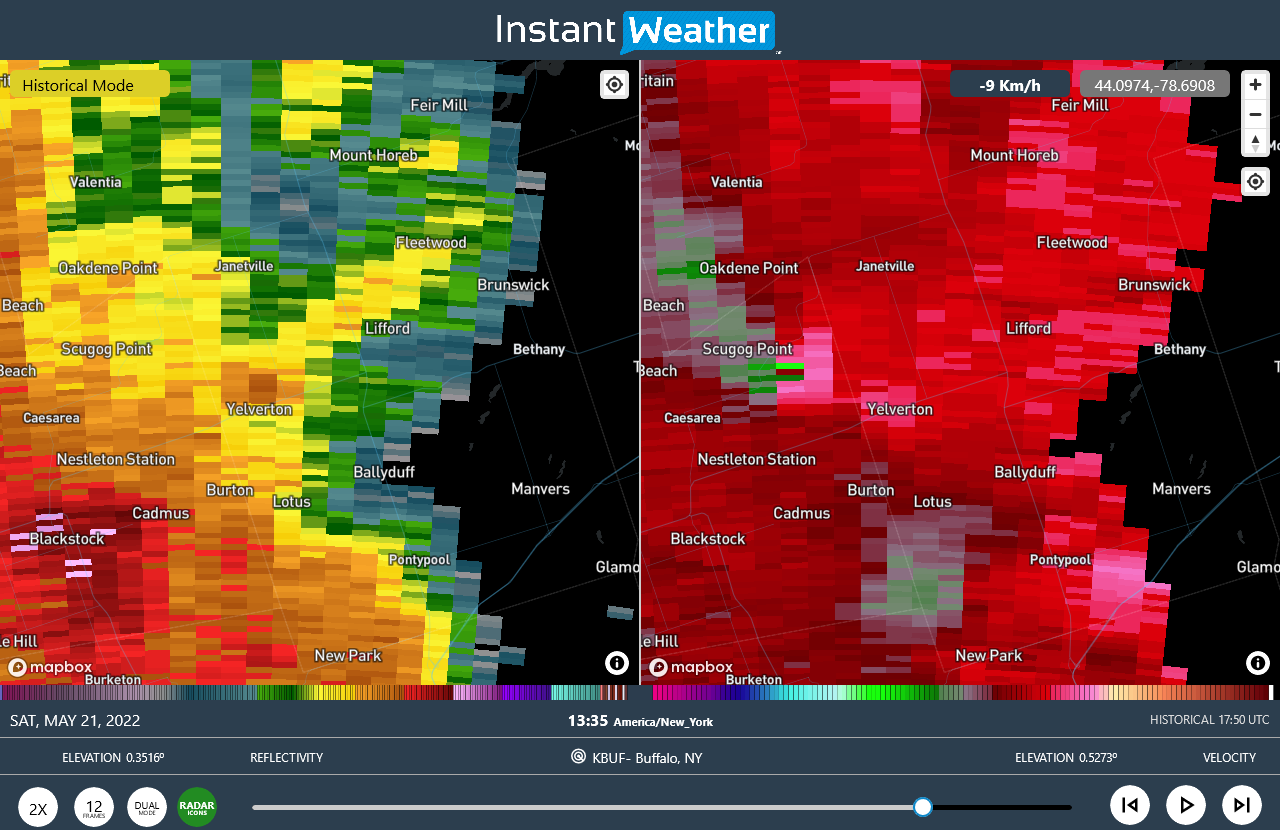
KBUF Doppler radar reflectivity (left) and radial velocity (right) showing a strong velocity couplet near St. Christopher (SE of Scugog Point) at 1:35 PM ET.
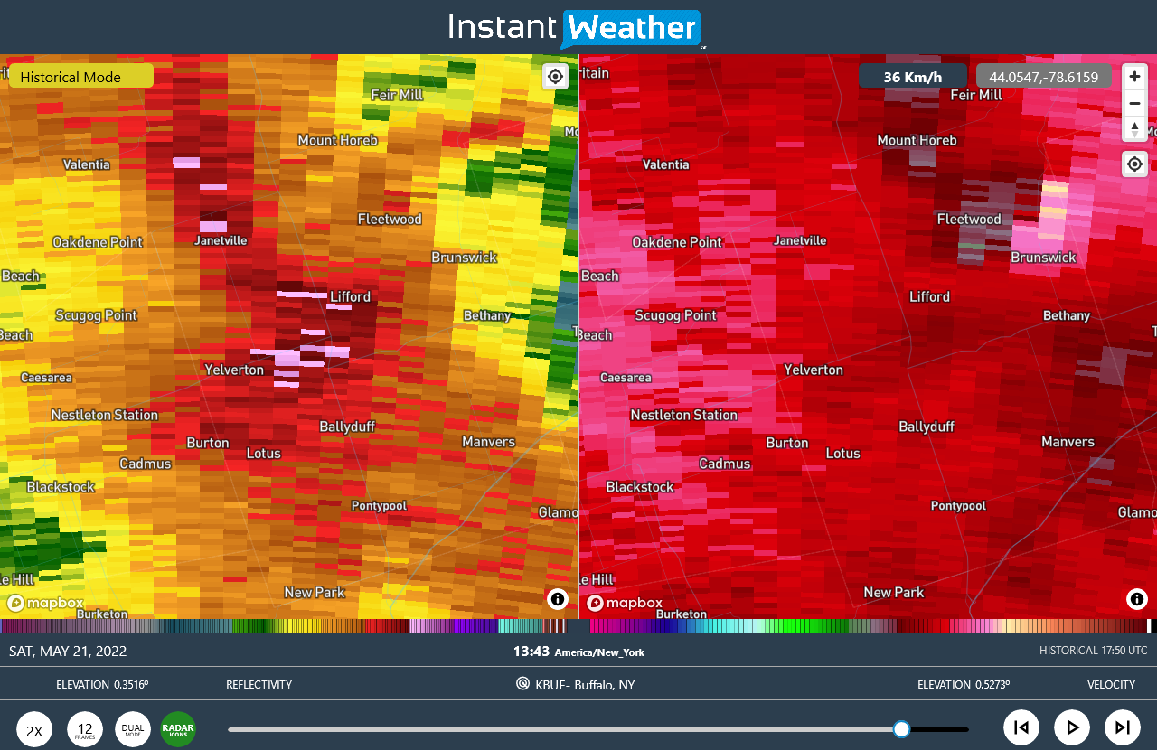
KBUF Doppler radar reflectivity (left) and radial velocity (right) showing a velocity couplet near Fleetwood at 1:43 PM ET. The storm was moving close to 120 km/h to the ENE at this point.