July 20th tornadoes in Ontario and Quebec
July 20th saw tornado watches and tornado warnings in southern Ontario, but the tornadoes that day ended up occurring in northeastern Ontario and western Quebec. One EF2 developed north of Sudbury, ON and at least four tornadoes with up to EF2 damage occurred in Quebec. Additional investigations by NTP may result in further tornado classifications.
Below are the summaries for the events as they have been investigated to date.
Event Name: Kalaco Lake (Sudbury), ON
Date: July 20, 2022
Start Time: 4:50 PM EDT (2050 UTC)
Final Classification: Tornado (Over Land)
Final EF-Scale Rating: EF2
EF-Scale Damage Indicator / Degree of Damage: C-T/DOD-6
Start of damage track: 47.1769N, 81.3872W
End of damage of track: 47.2933N, 81.3136W
Location of worst damage: 47.2317N, 81.3683W
Description: Tree damage was reported north of Sudbury and subsequent satellite imagery review revealed a tornado damage path through forested areas. Damage assessed as EF2 tornado, with an estimated max. wind speed of 190 km/h, track length of 14.4 km and max. path width of 410 m. Tornado motion was from the SSW (approx. 205 degrees). Start time is radar estimated.
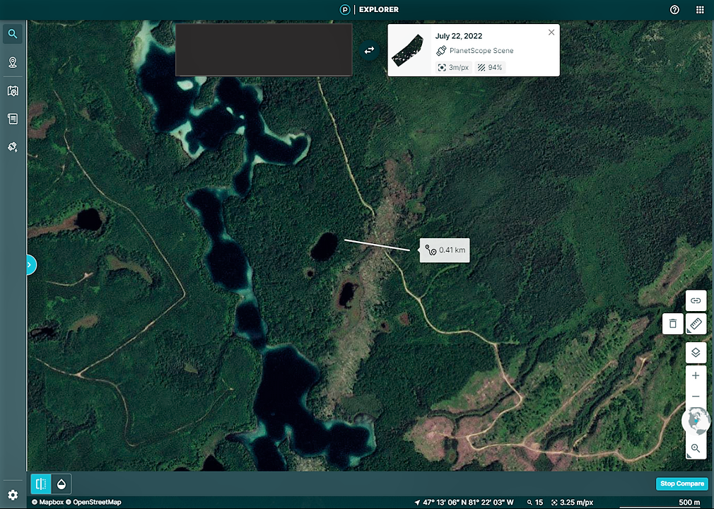
Planet.com satellite imagery showing a clear swath of downed trees that represents the worst and widest damage from the Kalaco Lake, ON EF2 tornado.
Event Name: Lac des Deux Iles (Temiscamingue), QC
Date: July 20, 2022
Start Time: 4:55 PM EDT (2055 UTC)
Final Classification: Tornado (Over Land)
Final EF-Scale Rating: EF1
EF-Scale Damage Indicator / Degree of Damage: C-T/DOD-5
Start of damage track: 46.8019N, 78.0175W
End of damage of track: 46.8586N, 77.9389W
Location of worst damage: 46.8339N, 77.9714W
Description: Satellite imagery review of a storm track revealed a tornado damage path through forested areas. Damage assessed as EF1 tornado, with an estimated max. wind speed of 145 km/h, track length of 8.79 km and max. path width of 140 m. Tornado motion was from the SW (approx. 225 degrees). Start time is radar estimated.
Event Name: Lac Plantin (Temiscamingue), QC
Date: July 20, 2022
Start Time: 6:40 PM EDT (2240 UTC)
Final Classification: Tornado (Over Land)
Final EF-Scale Rating: EF2
EF-Scale Damage Indicator / Degree of Damage: C-T/DOD-6
Start of damage track: 46.8725N, 78.2997W
End of damage of track: 46.9553N, 78.2536W
Location of worst damage: 46.9381N, 78.2681W
Description: Satellite imagery review of a storm track revealed a tornado damage path through forested areas. Damage assessed as EF2 tornado, with an estimated max. wind speed of 190 km/h, track length of 10.0 km and max. path width of 520 m. Tornado motion was from the SSW (approx. 200 degrees). Start time is radar estimated.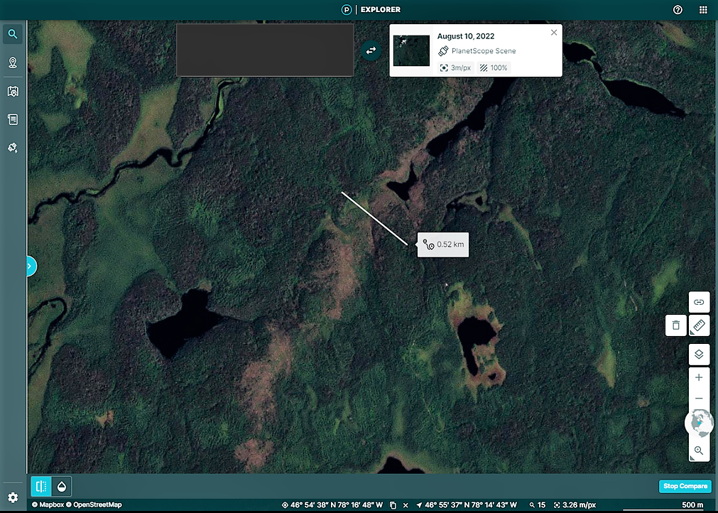
Planet.com satellite imagery showing a clear swath of downed trees that represents the worst and widest damage from the Lac Plantin, QC EF2 tornado.
Event Name: Lac Pedro (Pontiac), QC
Date: July 20, 2022
Start Time: 9:30 PM EDT (0130 UTC)
Final Classification: Tornado (Over Land)
Final EF-Scale Rating: EF2
EF-Scale Damage Indicator / Degree of Damage: C-T/DOD-6
Start of damage track: 47.2722N, 77.5194W
End of damage of track: 47.3558N, 77.4222W
Location of worst damage: 47.3192N, 77.4669W
Description: Satellite imagery review of a storm track revealed a tornado damage path through forested areas. Damage assessed as EF2 tornado, with an estimated max. wind speed of 190 km/h, track length of 12.1 km and max. path width of 370 m. Tornado motion was from the SSW (approx. 200 degrees). Additional visible damage beyond the end of the tornado will be assessed using high-resolution aerial imagery collected during a pending aircraft survey. Start time is radar estimated.
Event Name: Lac Landerneau (Vallee-de-l'Or), QC
Date: July 20, 2022
Start Time: 9:40 PM EDT (0140 UTC)
Final Classification: Tornado (Over Land)
Final EF-Scale Rating: EF1
EF-Scale Damage Indicator / Degree of Damage: C-T/DOD-5
Start of damage track: 47.2269N, 77.4089W
End of damage of track: 47.2369N, 77.3939W
Location of worst damage: 47.2292N, 77.4064W
Description: Satellite imagery review of a storm track revealed a short tornado damage path through forested areas. Damage assessed as EF1 tornado, with an estimated max. wind speed of 145 km/h, track length of 1.60 km and max. path width of 80 m. Tornado motion was from the SW (approx. 225 degrees). Start time is radar estimated.
Event Name: Lac Ombon (Temiscamingue), QC
Date: July 20, 2022
Start Time: 8:25 PM EDT (0025 UTC)
Preliminary Classification: Unclassified Wind Damage
Preliminary EF-Scale Rating: Pending
Damage area: 47.0925N, 77.8639W
Description: Satellite imagery review of a storm track revealed an area of tree damage near Lac Ombon, however evidence available at this time is insufficient to confirm event type and rating. Damage will be investigated further using high-resolution aerial imagery collected during a pending aircraft survey. Start time is radar estimated.