Northeast BC downbursts
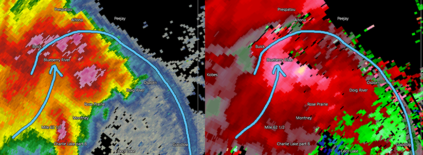
A powerful 'bow echo' storm moved through northeast BC on 30 Jun 2021, resulting in large areas of downburst damage. Embedded microbursts reached wind speeds up to 190 km/h, causing up to EF2 damage. In the image above, the left side is reflectivity from the CASSR radar and the right side is radial velocity, both valid at 10:24 PM MST. The blue line shows the leading edge of the bow while the blue arrow shows where the rear-inflow jet is resulting in a weak-echo notch. Detailed event summaries are provided below.
Event Name: Moberly Lake, BC
Date: June 30, 2021
Time: 8:45 PM MST (0345Z)
Final Classification: Downburst
Final EF-Scale Rating: EF1
EF-Scale Damage Indicator / Degree of Damage: C-T/DOD-5
Event location: 55.8263N, 121.5827W
Description: Tree damage was reported at Moberly Lake following a storm passing through. Satellite imagery review revealed visible tree damage in the area, and further east toward Bond and north along the Pine River. Damage assessed as EF1 downburst, with an estimated max. wind speed of 145 km/h.
Event Name: Red Creek Road (Montney), BC
Date: June 30, 2021
Time: 9:50 PM MST (0450Z)
Final Classification: Downburst
Final EF-Scale Rating: EF2
EF-Scale Damage Indicator / Degree of Damage: C-T/DOD-6
Event location: 56.3928N, 121.2518W
Description: Tree damage was reported along Red Creek Road and the Alaska Highway southwest of Montney following a storm passing through the area. Satellite imagery review revealed widespread tree damage in the region. High-resolution aerial imagery of the Red Creek Road area was collected on July 27, 2021. Imagery analysis confirmed a significant downburst event with evidence of embedded intense microbursts visible. Damage assessed at EF2 with an estimated max. wind speed of 190 km/h.
Event Name: Stoddart Creek (Montney), BC
Date: June 30, 2021
Time: 9:55 PM MST (0455Z)
Final Classification: Downburst
Final EF-Scale Rating: EF2
EF-Scale Damage Indicator / Degree of Damage: C-T/DOD-6
Event location: 56.5034N, 121.1171W
Description: Tree damage reported near Montney prompted satellite imagery review over the greater area. Widespread tree damage was observed in the region. High-resolution aerial imagery of the Stoddart Creek area was collected on July 27, 2021. Imagery analysis confirmed a significant downburst event with evidence of embedded intense microbursts visible. Damage assessed at EF2 with an estimated max. wind speed of 190 km/h.
Event Name: Lower Cache Road (Montney), BC
Date: June 30, 2021
Time: 10:00 PM MST (0500Z)
Final Classification: Downburst
Final EF-Scale Rating: EF1
EF-Scale Damage Indicator / Degree of Damage: C-T/DOD-5
Event location: 56.5794N, 121.2979W
Description: Tree damage reported near Montney prompted satellite imagery review over the greater area. Widespread tree damage was observed in the region. High-resolution aerial imagery of the Lower Cache Road area was collected on July 27, 2021. Imagery analysis confirmed a downburst event with evidence of embedded microbursts visible. Damage assessed at EF1 with an estimated max. wind speed of 170 km/h.
Event Name: Blueberry River First Nations, BC
Date: June 30, 2021
Time: 10:05 PM MST (0505Z)
Final Classification: Downburst
Final EF-Scale Rating: EF2
EF-Scale Damage Indicator / Degree of Damage: C-T/DOD-6
Event location: 56.6883N, 121.1291W
Description: Structural and tree damage was reported at Blueberry River First Nations southeast of Buick following a storm passing through the area. Satellite imagery review revealed widespread tree damage in the region. High-resolution aerial imagery was collected on July 27, 2021. Imagery analysis confirmed a significant downburst event with evidence of embedded intense microbursts visible. Damage assessed at EF2 with an estimated max. wind speed of 190 km/h.
Event Name: Altona, BC
Date: June 30, 2021
Time: 10:15 PM MST (0515Z)
Final Classification: Downburst
Final EF-Scale Rating: EF1
EF-Scale Damage Indicator / Degree of Damage: C-T/DOD-5
Event location: 56.8684N, 120.8912W
Description: Structural and tree damage was reported following a storm passing through the Altona area. Satellite imagery review revealed visible tree damage over a large area (including Altona, Prespatou and along the Beaton River). Damage assessed as EF1 downburst, with an estimated max. wind speed of 145 km/h.
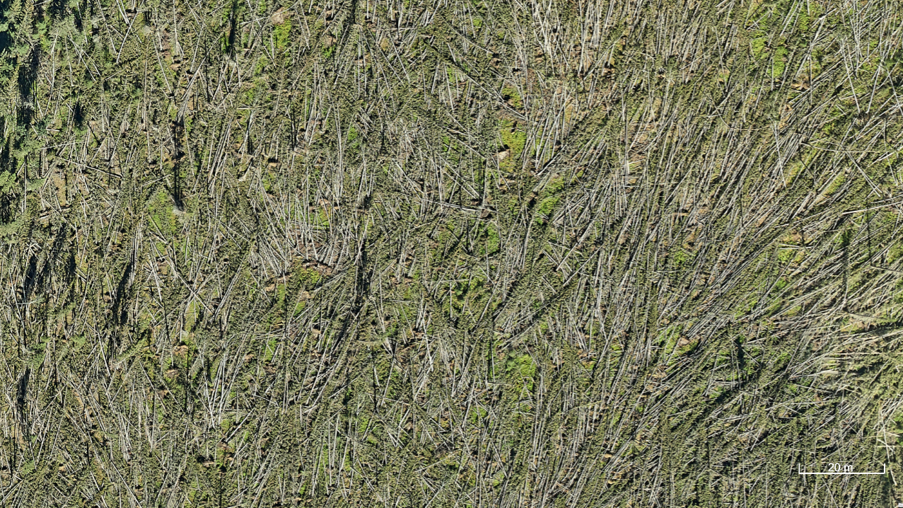
Aerial image at Red Creek Road (Montney), BC area showing virtually every tree uprooted or snapped by the downburst.