New ON tornadoes on May 25, Jun 11 and Jul 13
NTP has identified three new Ontario tornadoes - one at Gogama on May 25, a landspout tornado at Thorndale on Jun 11, and a new satellite tornado that accompanied the Beachburg tornado on Jul 13.
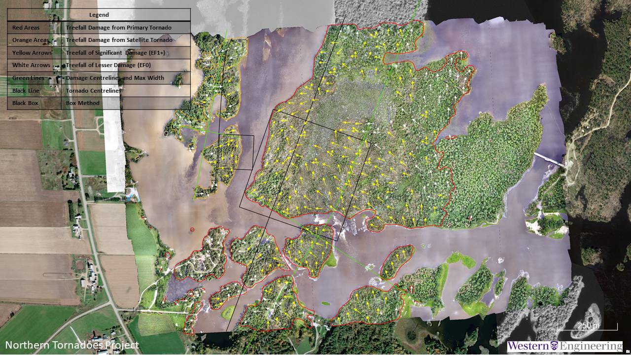
Careful and thorough analysis of drone aerial imagery was required to separate the tree damage from the Beachburg tornado and its concurrent satellite (see aerial image). The Beachburg tornado event details have been updated as well.
See details below.
- Event Name: Gogama, ON
- Date: May 25, 2021
- Time: 8:55 PM EDT (0055Z)
- Final Classification: Tornado (Over Land)
- Final EF-Scale Rating: EF1
- EF-Scale Damage Indicator / Degree of Damage: C-T/DOD-5
- Start of damage track: 47.6990N, 81.7334W
- End of damage of track: 47.7095N, 81.6646W
- Location of worst damage: 47.7035N, 81.6863W
- Description: Tree damage was reported north of Gogama following a storm passing through the area. Satellite imagery review revealed weak damage visible in the area of the report. Aerial imagery was collected June 15, 2021 and review revealed tornado damage track. Damage assessed as EF1 tornado, with an estimated max. wind speed of 145 km/h, track length of 5.44 km and max. path width of 180 m. Tornado motion was from the W (approx. 260 degrees).
- Event Name: Thorndale, ON
- Date: June 11, 2021
- Time: 5:15 PM EDT (2115Z)
- Final Classification: Tornado (Over Land)
- Final EF-Scale Rating: EF0 (def)
- Event location: 43.096N, 81.159W
- Description: Witness captured photos of a landspout tornado in Thorndale, where it persisted for more than 10 minutes in the yard of an industrial area. No damage was reported and satellite imagery review revealed no visible damage. Information available insufficient to accurately estimate track length, max. path width and tornado motion.
- Event Name: Beachburg, ON
- Date: July 13, 2021
- Time: 7:00 PM EDT (2300Z)
- Final Classification: Tornado (Over Land) - Primary
- Final EF-Scale Rating: EF2
- EF-Scale Damage Indicator / Degree of Damage: C-T/DOD-6
- Start of damage track: 45.7403N, 76.7903W
- End of damage of track: 45.7951N, 76.7615N
- Location of worst damage: 45.7527N, 76.7840W
- Description: Significant tree damage was reported near Beachburg after a storm passed through the area. Witnesses captured video of the storms and satellite imagery review revealed a track of visible tree damage. An NTP ground and drone survey was completed on July 15, 2021. Upon completion of tree fall analysis and review of witness accounts and video, two tornadoes developing from the same parent mesocyclone were confirmed. The primary tornado developed northeast of Beachburg, travelled northward over Sullivan Island and the Ottawa River and dissipated over L'Ile-de-Grand-Calumet, QC. A second (concurrent) satellite tornado developed on the northwest side of Sullivan Island, caused the tree damage at Butternut Island (west of the main track) and moved southward. Damage from the primary tornado was assessed as EF2, with an estimated max. wind speed of 190 km/h, track length of 6.94 km and max. path width of 930 m. Tornado motion of the primary tornado was from the SSW (approx. 200 degrees). The satellite tornado damage was assessed as EF1, with estimated max. wind speed of 145 km/h, track length of 1.44 km and max. path width of 310 m. Tornado motion of the satellite tornado was from the NNE (approx. 30 degrees).
- Event Name: Butternut Island (Beachburg), ON
- Date: July 13, 2021
- Time: 7:00 PM EDT (2300Z)
- Final Classification: Tornado (Over Land) - Secondary
- Final EF-Scale Rating: EF1
- EF-Scale Damage Indicator / Degree of Damage: C-T/DOD-5
- Start of damage track: 45.7625N, 76.7797W
- End of damage of track: 45.7536N, 76.7879W
- Location of worst damage: 45.752N, 76.7881W
- Description: Significant tree damage was reported near Beachburg after a storm passed through the area. Witnesses captured video of the storms and satellite imagery review revealed a track of visible tree damage. An NTP ground and drone survey was completed on July 15, 2021. Upon completion of tree fall analysis and review of witness accounts and video, two tornadoes developing from the same parent mesocyclone were confirmed. The primary tornado developed northeast of Beachburg, travelled northward over Sullivan Island and the Ottawa River and dissipated over L'Ile-de-Grand-Calumet, QC. A second (concurrent) satellite tornado developed on the northwest side of Sullivan Island, caused the tree damage at Butternut Island (west of the main track) and moved southward. The satellite tornado damage was assessed as EF1, with estimated max. wind speed of 145 km/h, track length of 1.44 km and max. path width of 310 m. Tornado motion of the satellite tornado was from the NNE (approx. 30 degrees). Damage from the primary tornado was assessed as EF2, with an estimated max. wind speed of 190 km/h, track length of 6.94 km and max. path width of 930 m. Tornado motion of the primary tornado was from the SSW (approx. 200 degrees).