Eden-Walsh, ON damage survey
At 9:30 PM on September 12, 2021, a large bow echo storm passed through parts of Southwestern Ontario, travelling from the shore of Lake Huron southeast through Lambton County, Middlesex County, Norfolk County, to the shore of Lake Erie. A bow echo storm is similar to a squall line but smaller in scale and is associated with a strong inflow at the back (rear) end of the system. During this bow echo stage, it is possible for tornadoes to develop on the gust front of the storm (which occurred in Parkhill, ON with this specific storm). As this rear inflow increases, the bow echo begins to push outwards, transitioning into a “comma echo” and then eventually dying out. Figure 1 shows a diagram from Ted Fujita’s “Manual of Downburst Identification for Project NIMROD” (Fujita, 1978) showing how a bow echo storm develops and then dissipates. Figure 2 shows a radar snapshot from the September 12th storm, while the storm was transitioning into a comma echo.
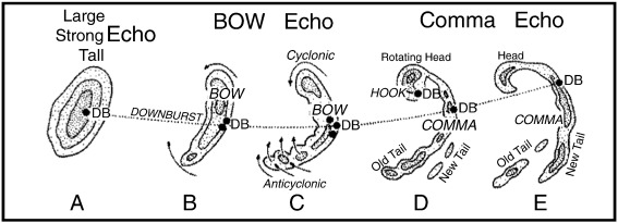
Figure 1: A typical progression of radar echoes associated with strong and extensive downbursts (Fujita, 1978).
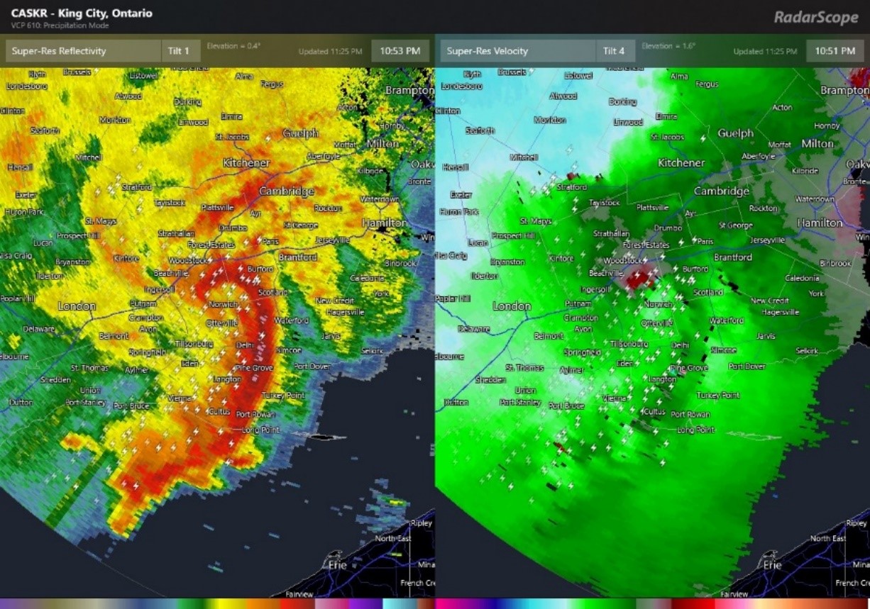
Figure 2: CASKR Radar showing Reflectivity - Tilt 1 and Velocity - Tilt 4 (RadarScope).
Originally, an NTP ground and drone survey was conducted on September 13, 2021 in Parkhill, ON and Ailsa Craig, ON resulting in classifications of an EF1 tornado and EF1 downburst respectively. However, after damage was reported by the public in Walsh, ON, a NTP team was sent to the area on September 16, 2021. The survey performed in the area documented tree, crop, and some structural damage extending over a distance of over 35 km through the communities of Mabee’s Corners, South Middleton, Wyecombe, Glenshee, Silver Hill, Pine Grove, Walsh and Vittoria. Figure 3 shows two drone photographs from the NTP survey detailing crop and tree damage.
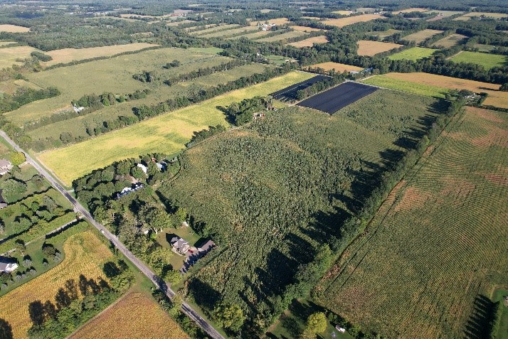
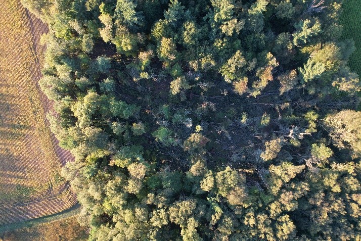
Figure 3: Drone photographs from the NTP survey on September 16, 2021 showing crop (left) and tree (right) damage in the Eden-Walsh area.
This event was complicated to classify for a few reasons. The ground and drone survey noted thin and long continuous paths of intense damage with surrounding minor damage, which would normally indicate a tornado that was imbedded in the gust front of a bow echo system. However, normally in a tornadic event, damage patterns in crops and trees will be convergent (i.e. they’ll point towards the centreline of the tornado), and chaotic. In this case, the damage in the crops and trees seemed to all point to the southeast. This led us to three possibilities:
* A downburst with particularly intense damage swaths / microbursts embedded within the larger downburst.
One of the services that NTP uses to classify wind events is daily satellite imagery from Planet Labs. In the end, consulting the satellite imagery helped us narrow down what type of event this was. From the satellite imagery, it was determined that the damage was much more widespread than what was noted on the ground and drone survey, with a maximum width of approximately 8 km. This eliminated the possibility of a tornado and a non-tornadic mesovortex as the damage was too widespread to have been caused by either type of event. Therefore, the event was rated as a downburst with notable intense burst swaths. Figure 4 demonstrates these different downburst scales and their associated damage patterns (Fujita & Wakimoto, 1981).
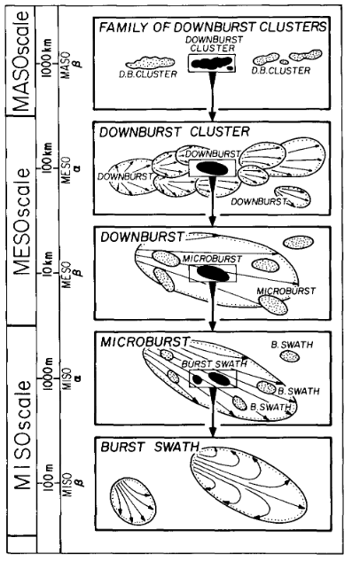
Figure 4: Five scales of downburst damage patterns (Fujita & Wakimoto, 1981).
In Fujita & Wakimoto, it specifically says: “A burst swath, particularly a long and narrow one, is characterized by damage typical of tornadoes”, which ended up being the case for the Eden-Walsh event. Overall, this event serves as a good example of the importance of thorough classification, and the usefulness of satellite imagery in capturing the entire extent of an event.
References
Fujita, T. T., 1978: Manual of downburst identification for project Nimrod. Satellite and Mesometeorology Research Paper, 156, 108 p.
Fujita, T. T., and R. M. Wakimoto, 1981: Five scales of airflow associated with a series of downbursts on 16 July 1980. Monthly Weather Review,109, 1438-1456.